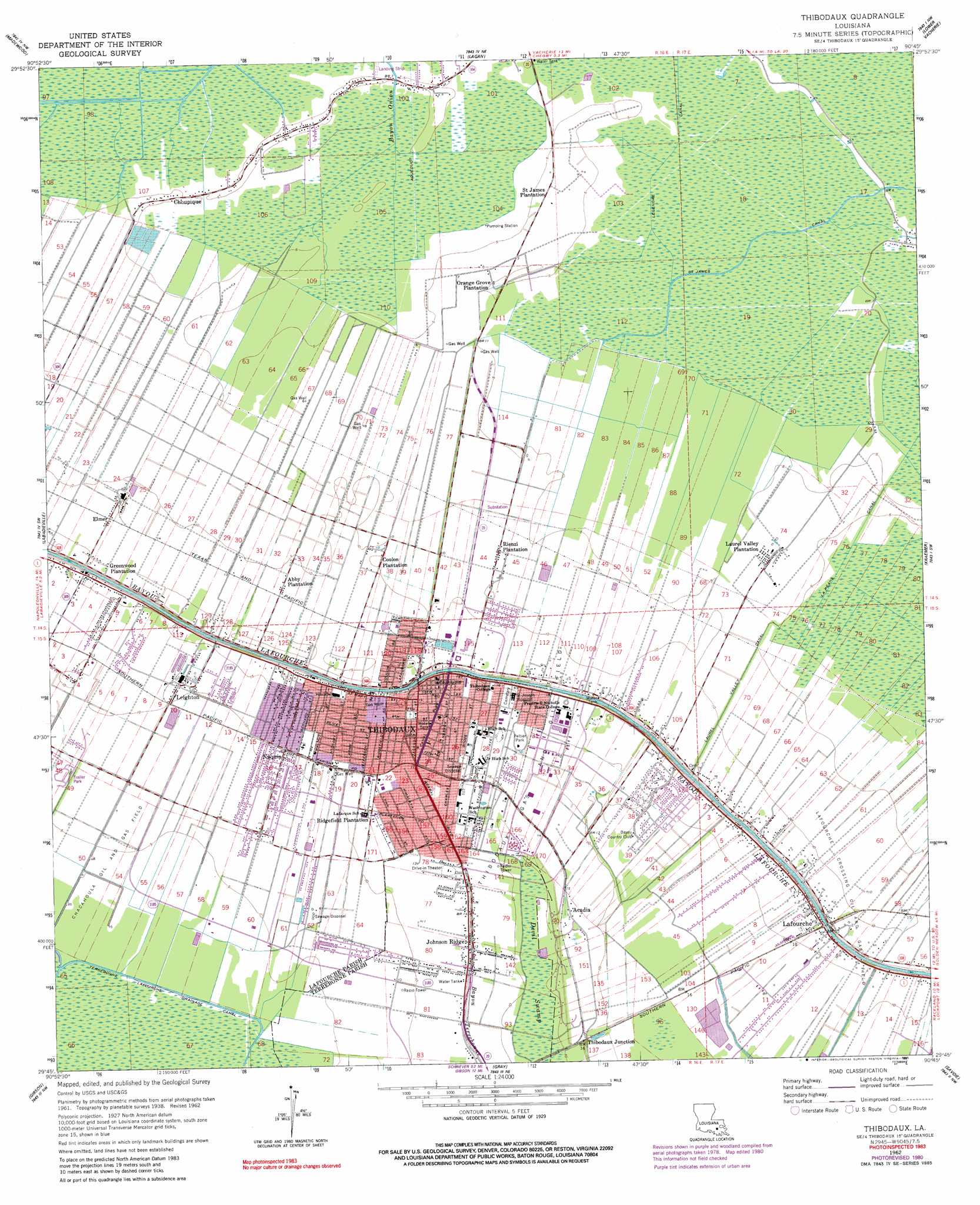
Thibodaux Topo Map Louisiana
To zoom in, hover over the map of Thibodaux
USGS Topo Quad 29090g7 - 1:24,000 scale
| Topo Map Name: | Thibodaux |
| USGS Topo Quad ID: | 29090g7 |
| Print Size: | ca. 21 1/4" wide x 27" high |
| Southeast Coordinates: | 29.75° N latitude / 90.75° W longitude |
| Map Center Coordinates: | 29.8125° N latitude / 90.8125° W longitude |
| U.S. State: | LA |
| Filename: | o29090g7.jpg |
| Download Map JPG Image: | Thibodaux topo map 1:24,000 scale |
| Map Type: | Topographic |
| Topo Series: | 7.5´ |
| Map Scale: | 1:24,000 |
| Source of Map Images: | United States Geological Survey (USGS) |
| Alternate Map Versions: |
Lafourche LA 1938 Download PDF Buy paper map Thibodaux LA 1962, updated 1963 Download PDF Buy paper map Thibodaux LA 1962, updated 1971 Download PDF Buy paper map Thibodaux LA 1962, updated 1981 Download PDF Buy paper map Thibodaux LA 1962, updated 1991 Download PDF Buy paper map Thibodaux LA 1998, updated 2000 Download PDF Buy paper map Thibodaux LA 2012 Download PDF Buy paper map Thibodaux LA 2015 Download PDF Buy paper map |
1:24,000 Topo Quads surrounding Thibodaux
Belle Rose |
Donaldsonville |
Convent |
Lutcher |
Reserve |
Napoleonville |
Madewood |
Lagan |
Lower Vacherie |
Lac Des Allemands |
Grassy Lake |
Labadieville |
Thibodaux |
Kraemer |
Bayou Boeuf |
Amelia |
Gibson |
Gray |
Savoie |
Lockport |
Morgan City Se |
Bayou Cocodrie |
Humphreys |
Houma |
Bourg |
> Back to 29090e1 at 1:100,000 scale
> Back to 29090a1 at 1:250,000 scale
> Back to U.S. Topo Maps home
Thibodaux topo map: Gazetteer
Thibodaux: Airports
Thibodaux Hospital and Health Center Heliport elevation 4m 13′Thibodaux: Canals
Legendre Canal elevation 0m 0′Thibodaux: Dams
Louisiana Noname Three Dam elevation 4m 13′Southdown Sugar Millwater Storage Dam elevation 4m 13′
Thibodaux: Oilfields
North Thibodaux Gas Field elevation 2m 6′South Chegby Gas Field elevation 0m 0′
Thibodaux Gas and Oil Field elevation 3m 9′
Thibodaux: Parks
Acadia Park elevation 3m 9′Didier Field elevation 3m 9′
Guidry Stadium elevation 3m 9′
Heros Park elevation 2m 6′
Memorial Fountain elevation 4m 13′
Peltier Park elevation 3m 9′
Thibodaux: Populated Places
Abby Plantation elevation 3m 9′Acadia elevation 4m 13′
Acadian Villa elevation 3m 9′
Beaujolais elevation 2m 6′
Brandywine elevation 2m 6′
Choupique elevation 2m 6′
Coulon Plantation elevation 3m 9′
Elmer elevation 4m 13′
Greenwood Acres elevation 4m 13′
Greewood Plantation elevation 4m 13′
Johnson Ridge elevation 4m 13′
Lafourche elevation 4m 13′
Laurel Valley Plantation elevation 3m 9′
Leighton elevation 3m 9′
Naquin elevation 3m 9′
Orange Grove Plantation elevation 2m 6′
Plantation Acres elevation 3m 9′
Rienzi Plantation elevation 2m 6′
Thibodaux elevation 4m 13′
Thibodaux Junction elevation 5m 16′
Twelve Cedars elevation 1m 3′
Waverly Mobile Home Park elevation 2m 6′
Thibodaux: Post Offices
Thibodaux Post Office elevation 4m 13′Thibodaux: Swamps
Devil Swamp elevation 1m 3′Thibodaux digital topo map on disk
Buy this Thibodaux topo map showing relief, roads, GPS coordinates and other geographical features, as a high-resolution digital map file on DVD: