Lac Des Allemands Topo Map Louisiana
To zoom in, hover over the map of Lac Des Allemands
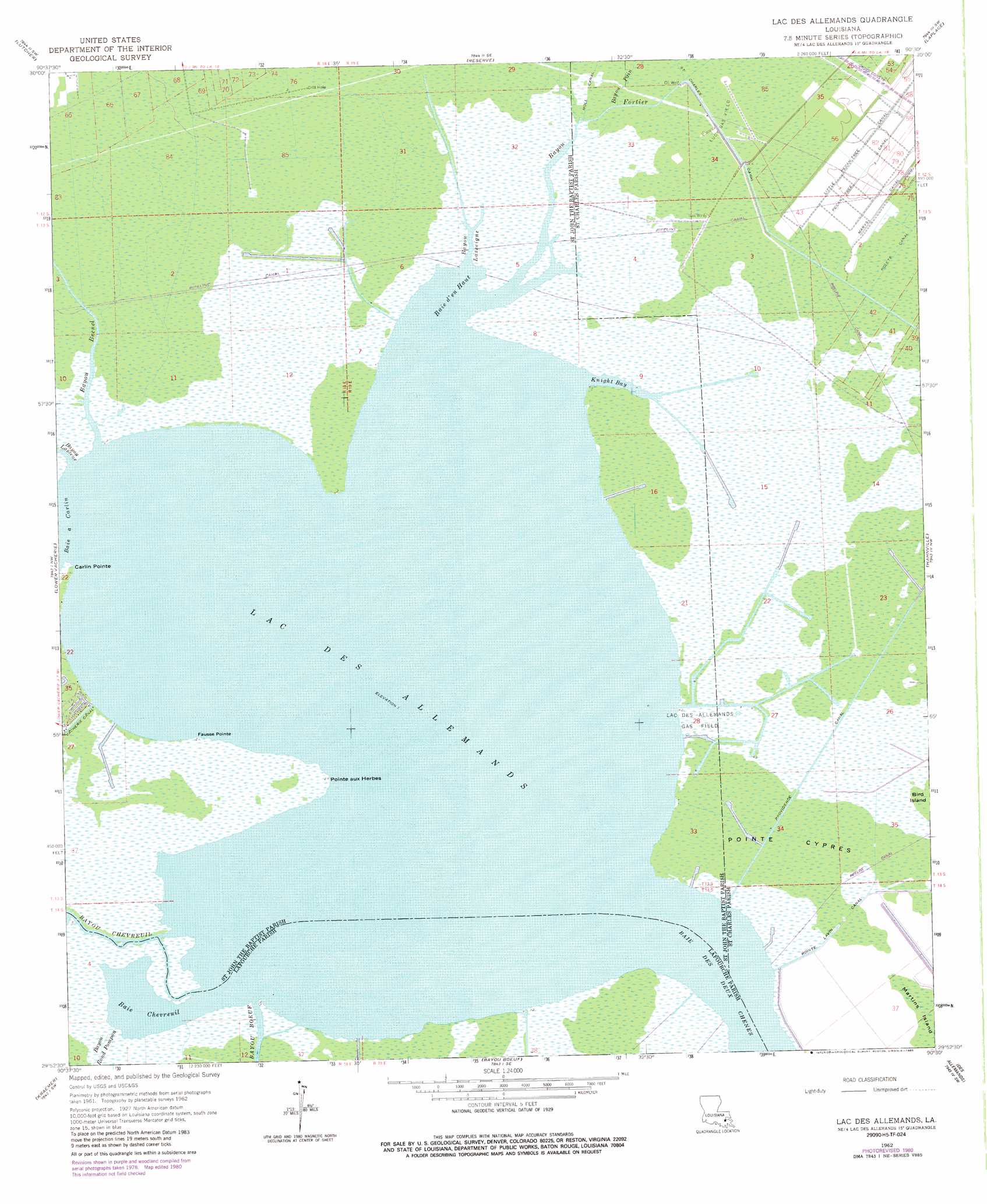
USGS Topo Quad 29090h5 - 1:24,000 scale
| Topo Map Name: | Lac Des Allemands |
| USGS Topo Quad ID: | 29090h5 |
| Print Size: | ca. 21 1/4" wide x 27" high |
| Southeast Coordinates: | 29.875° N latitude / 90.5° W longitude |
| Map Center Coordinates: | 29.9375° N latitude / 90.5625° W longitude |
| U.S. State: | LA |
| Filename: | o29090h5.jpg |
| Download Map JPG Image: | Lac Des Allemands topo map 1:24,000 scale |
| Map Type: | Topographic |
| Topo Series: | 7.5´ |
| Map Scale: | 1:24,000 |
| Source of Map Images: | United States Geological Survey (USGS) |
| Alternate Map Versions: |
Lac Des Allemands LA 1962, updated 1963 Download PDF Buy paper map Lac Des Allemands LA 1962, updated 1971 Download PDF Buy paper map Lac Des Allemands LA 1962, updated 1981 Download PDF Buy paper map Lac des Allemands LA 2012 Download PDF Buy paper map Lac des Allemands LA 2015 Download PDF Buy paper map |
1:24,000 Topo Quads surrounding Lac Des Allemands
Sorrento |
Mount Airy Nw |
Mount Airy Ne |
Ruddock |
Bonnett Carre Ne |
Convent |
Lutcher |
Reserve |
Laplace |
La Branche |
Lagan |
Lower Vacherie |
Lac Des Allemands |
Hahnville |
Luling |
Thibodaux |
Kraemer |
Bayou Boeuf |
Des Allemands |
Lake Cataouatche West |
Gray |
Savoie |
Lockport |
Gheens |
Catahoula Bay |
> Back to 29090e1 at 1:100,000 scale
> Back to 29090a1 at 1:250,000 scale
> Back to U.S. Topo Maps home
Lac Des Allemands topo map: Gazetteer
Lac Des Allemands: Bays
Baie a Carlin elevation 0m 0′Baie Chevreuil elevation 0m 0′
Baie d'en Haut elevation 0m 0′
Baie Des Deux Chenes elevation 0m 0′
Bayou Lasseigne elevation 0m 0′
Knight Bay elevation 0m 0′
Lac Des Allemands: Canals
Little Pecan Tree Canal elevation 1m 3′Pecan Tree Canal elevation 1m 3′
Pointe Lavin Canal elevation 0m 0′
Providence Canal elevation 0m 0′
Saint Charles Canal elevation 1m 3′
Lac Des Allemands: Capes
Carlin Pointe elevation 0m 0′Fausse Pointe elevation 0m 0′
Pointe aux Herbes elevation 0m 0′
Pointe Cypres elevation 0m 0′
Lac Des Allemands: Islands
Knights Bay Island elevation 1m 3′Lac Des Allemands: Lakes
Lac des Allemands elevation 0m 0′Lac Des Allemands: Oilfields
Lacs Des Atlemands Gas Field elevation 1m 3′Lake Lucy Gas Field elevation 0m 0′
Lucy Gas Field elevation 0m 0′
Lucy Gas Field elevation 0m 0′
Martin Island Gas Field elevation 0m 0′
Lac Des Allemands: Streams
Bayou Becnel elevation 0m 0′Bayou Boeuf elevation 0m 0′
Bayou Chevreuil elevation 0m 0′
Bayou Fortier elevation 0m 0′
Bayou Lassene elevation 0m 0′
Bayou Pain elevation 0m 0′
Bayou Rond Pompon elevation 0m 0′
Lac Des Allemands digital topo map on disk
Buy this Lac Des Allemands topo map showing relief, roads, GPS coordinates and other geographical features, as a high-resolution digital map file on DVD: