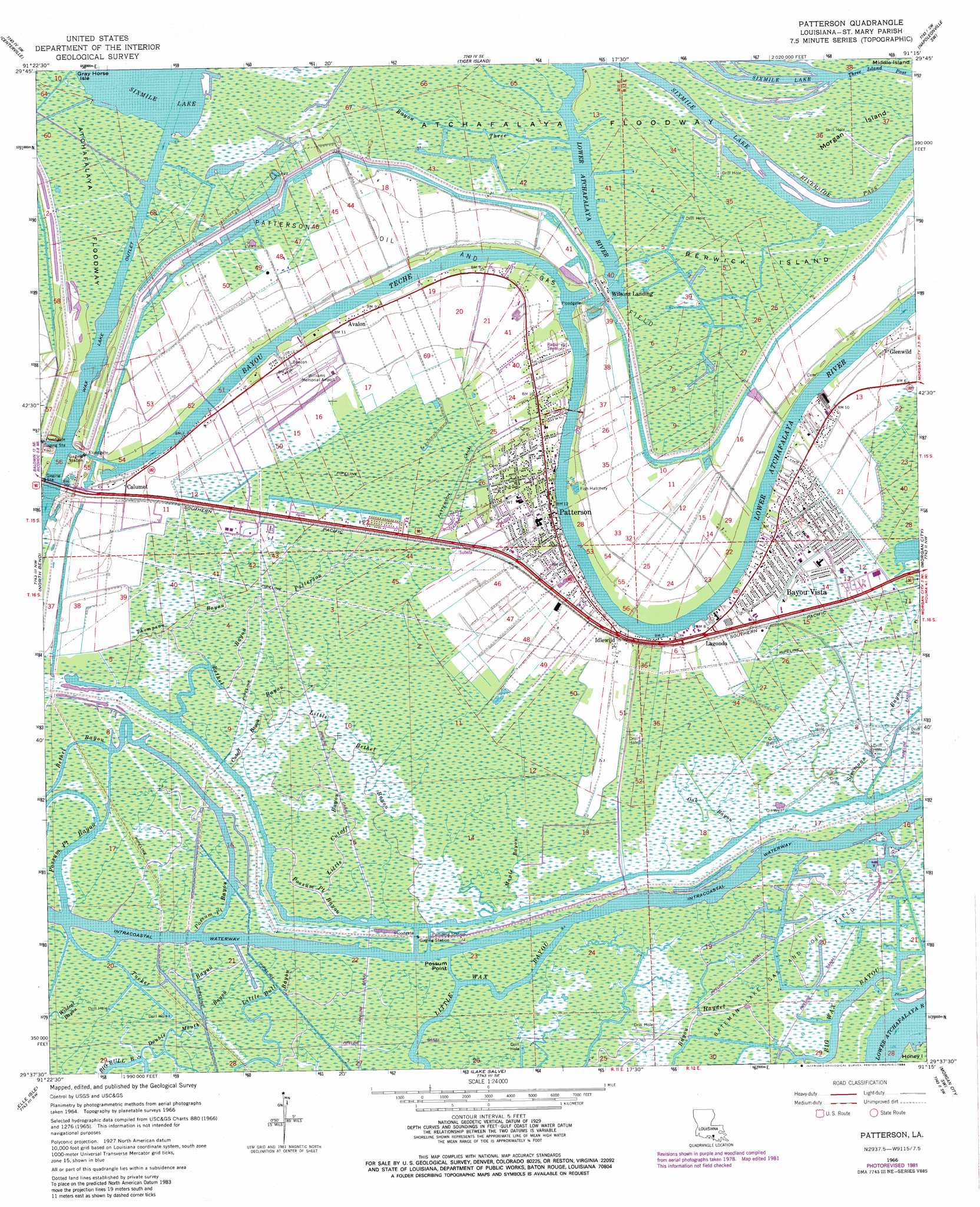
Patterson Topo Map Louisiana
To zoom in, hover over the map of Patterson
USGS Topo Quad 29091f3 - 1:24,000 scale
| Topo Map Name: | Patterson |
| USGS Topo Quad ID: | 29091f3 |
| Print Size: | ca. 21 1/4" wide x 27" high |
| Southeast Coordinates: | 29.625° N latitude / 91.25° W longitude |
| Map Center Coordinates: | 29.6875° N latitude / 91.3125° W longitude |
| U.S. State: | LA |
| Filename: | o29091f3.jpg |
| Download Map JPG Image: | Patterson topo map 1:24,000 scale |
| Map Type: | Topographic |
| Topo Series: | 7.5´ |
| Map Scale: | 1:24,000 |
| Source of Map Images: | United States Geological Survey (USGS) |
| Alternate Map Versions: |
Patterson LA 1966, updated 1967 Download PDF Buy paper map Patterson LA 1966, updated 1981 Download PDF Buy paper map Patterson LA 1966, updated 1984 Download PDF Buy paper map Patterson LA 1966, updated 1984 Download PDF Buy paper map Patterson LA 1994, updated 1998 Download PDF Buy paper map Patterson LA 2012 Download PDF Buy paper map Patterson LA 2015 Download PDF Buy paper map |
1:24,000 Topo Quads surrounding Patterson
Charenton |
Centerville Nw |
Centerville Ne |
Pierre Part |
Napoleonville |
Franklin |
Centerville |
Tiger Island |
Napoleonville Sw |
Grassy Lake |
Ellerslie |
North Bend |
Patterson |
Morgan City |
Amelia |
Point Chevreuil |
Belle Isle |
Lake Salve |
Morgan City Sw |
Morgan City Se |
Point Au Fer Ne |
Plumb Bayou |
Carencro Bayou |
> Back to 29091e1 at 1:100,000 scale
> Back to 29090a1 at 1:250,000 scale
> Back to U.S. Topo Maps home
Patterson topo map: Gazetteer
Patterson: Airports
Aquatic Aviation Seaplane Base elevation 2m 6′Harry P Williams Memorial Airport elevation 3m 9′
Williams Memorial Airport elevation 0m 0′
Patterson: Canals
Patterson Canal elevation 0m 0′Patterson: Capes
Possum Point elevation 0m 0′Patterson: Channels
Riverside Pass elevation 1m 3′Three Island Pass elevation 1m 3′
Patterson: Guts
Possum Point Bayou elevation 0m 0′Patterson: Islands
Berwick Island elevation 1m 3′Morgan Island elevation 1m 3′
Patterson: Oilfields
Patterson Oil and Gas Field elevation 2m 6′Patterson: Parks
Bayou Vista Park elevation 2m 6′Kemper Williams Park elevation 1m 3′
Victoria Park elevation 1m 3′
Patterson: Populated Places
Avalon elevation 3m 9′Bayou Vista elevation 2m 6′
Calumet elevation 2m 6′
Glenwild elevation 3m 9′
Idlewild elevation 3m 9′
Lagonda elevation 2m 6′
Patterson elevation 3m 9′
Wilsons Landing elevation 4m 13′
Patterson: Post Offices
Patterson Post Office elevation 2m 6′Patterson: Streams
Bayou Patterson elevation -1m -4′Bayou Teche elevation 1m 3′
Bayou Three elevation 1m 3′
Bethel Bayou elevation -1m -4′
Cutoff Bayou elevation -1m -4′
Double Mouth Bayou elevation 1m 3′
Little Bethel Bayou elevation 0m 0′
Little Cutoff Bayou elevation -1m -4′
Maple Bayou elevation 0m 0′
Oak Bayou elevation 0m 0′
Simmons Bayou elevation -1m -4′
Thompson Bayou elevation -1m -4′
Tucker Bayou elevation 0m 0′
Patterson digital topo map on disk
Buy this Patterson topo map showing relief, roads, GPS coordinates and other geographical features, as a high-resolution digital map file on DVD: