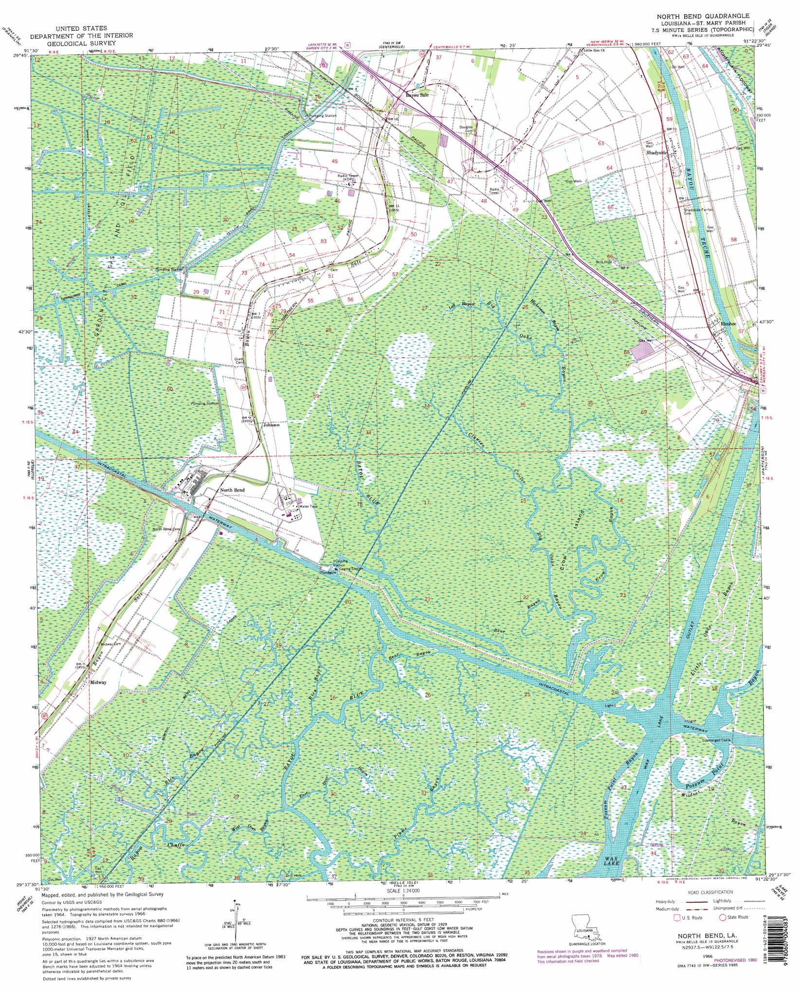
North Bend Topo Map Louisiana
To zoom in, hover over the map of North Bend
USGS Topo Quad 29091f4 - 1:24,000 scale
| Topo Map Name: | North Bend |
| USGS Topo Quad ID: | 29091f4 |
| Print Size: | ca. 21 1/4" wide x 27" high |
| Southeast Coordinates: | 29.625° N latitude / 91.375° W longitude |
| Map Center Coordinates: | 29.6875° N latitude / 91.4375° W longitude |
| U.S. State: | LA |
| Filename: | o29091f4.jpg |
| Download Map JPG Image: | North Bend topo map 1:24,000 scale |
| Map Type: | Topographic |
| Topo Series: | 7.5´ |
| Map Scale: | 1:24,000 |
| Source of Map Images: | United States Geological Survey (USGS) |
| Alternate Map Versions: |
North Bend LA 1966, updated 1967 Download PDF Buy paper map North Bend LA 1966, updated 1981 Download PDF Buy paper map North Bend LA 1966, updated 1981 Download PDF Buy paper map North Bend LA 1994, updated 1998 Download PDF Buy paper map North Bend LA 2012 Download PDF Buy paper map North Bend LA 2015 Download PDF Buy paper map |
1:24,000 Topo Quads surrounding North Bend
Jeanerette |
Charenton |
Centerville Nw |
Centerville Ne |
Pierre Part |
Kemper |
Franklin |
Centerville |
Tiger Island |
Napoleonville Sw |
Marone Point |
Ellerslie |
North Bend |
Patterson |
Morgan City |
Lake Point |
Point Chevreuil |
Belle Isle |
Lake Salve |
Morgan City Sw |
Point Au Fer Ne |
Plumb Bayou |
> Back to 29091e1 at 1:100,000 scale
> Back to 29090a1 at 1:250,000 scale
> Back to U.S. Topo Maps home
North Bend topo map: Gazetteer
North Bend: Canals
Lattery Canal elevation 0m 0′North Bend Canal elevation 0m 0′
Yellow Bayou Canal elevation 0m 0′
North Bend: Channels
Wax Lake Outlet elevation 0m 0′Wax North Channel elevation 0m 0′
Wax South Channel elevation 0m 0′
North Bend: Islands
Crow Island elevation -1m -4′North Bend: Oilfields
Garden City Gas and Oil Field elevation 1m 3′North Bend: Populated Places
Balco elevation 3m 9′Bayou Sale elevation 2m 6′
Cabot elevation 1m 3′
Clausen elevation 2m 6′
Fairfax elevation 3m 9′
Johnson elevation 2m 6′
Maria elevation 3m 9′
Maryland elevation 2m 6′
Midway elevation 1m 3′
North Bend elevation 2m 6′
Ricohoc elevation 3m 9′
Shadyside elevation 3m 9′
Todd elevation 2m 6′
North Bend: Streams
Bayou Blue elevation 0m 0′Bear Bayou elevation 0m 0′
Bear Bayou elevation 0m 0′
Bethel Bayou elevation 0m 0′
Big Oaks Bayou elevation -1m -4′
Clausen Coulee elevation 0m 0′
Crow Bayou elevation -1m -4′
East Over Bayou elevation 0m 0′
Hickerson Bayou elevation 0m 0′
Little Oaks Bayou elevation 0m 0′
Log Bayou elevation 0m 0′
Plume Bayou elevation 0m 0′
Rice Bayou elevation 0m 0′
Rice Bayou elevation 0m 0′
West Over Bayou elevation 1m 3′
Wildcat Bayou elevation 1m 3′
North Bend: Swamps
Berwick Pocket elevation 1m 3′North Bend digital topo map on disk
Buy this North Bend topo map showing relief, roads, GPS coordinates and other geographical features, as a high-resolution digital map file on DVD: