Napoleonville Topo Map Louisiana
To zoom in, hover over the map of Napoleonville
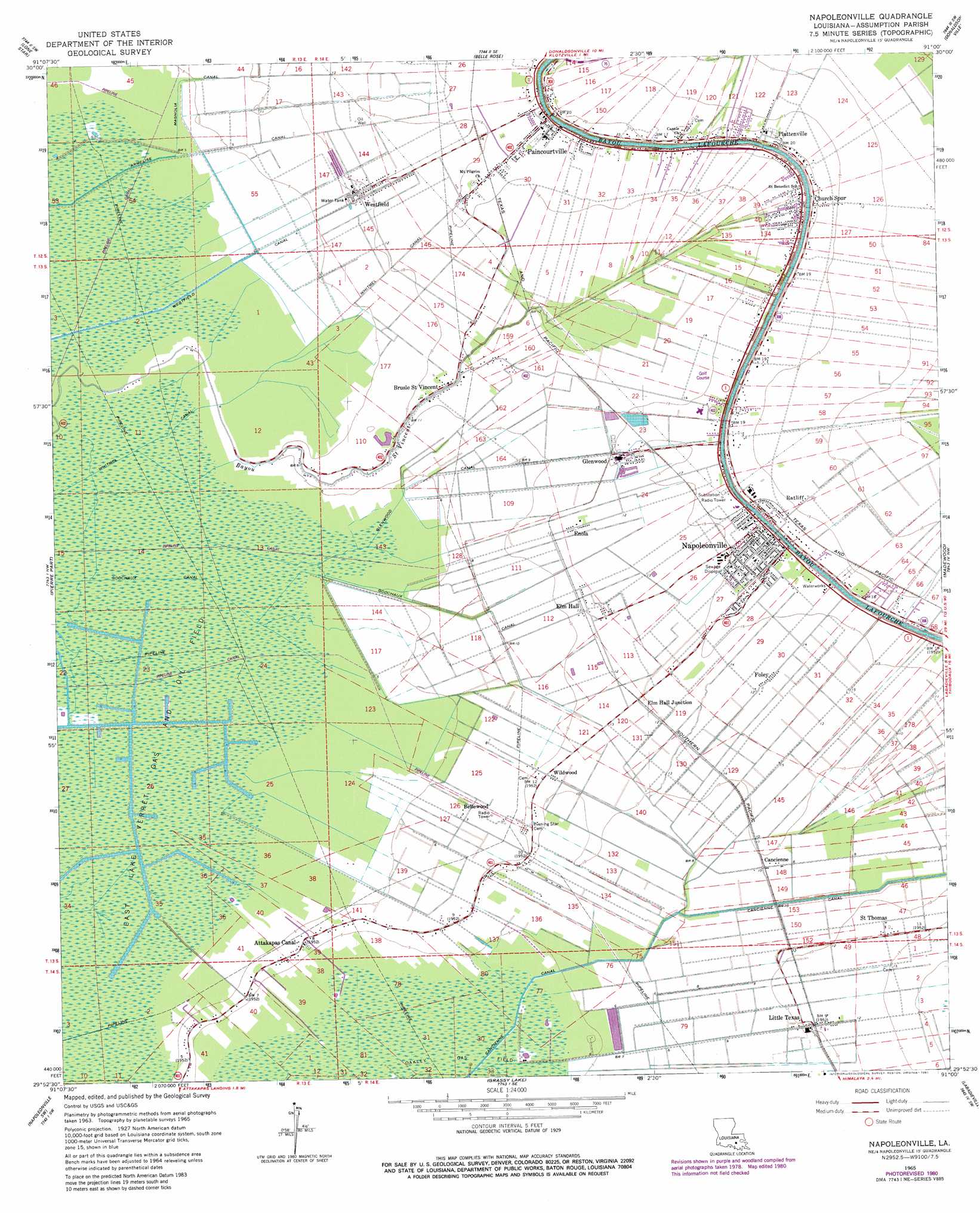
USGS Topo Quad 29091h1 - 1:24,000 scale
| Topo Map Name: | Napoleonville |
| USGS Topo Quad ID: | 29091h1 |
| Print Size: | ca. 21 1/4" wide x 27" high |
| Southeast Coordinates: | 29.875° N latitude / 91° W longitude |
| Map Center Coordinates: | 29.9375° N latitude / 91.0625° W longitude |
| U.S. State: | LA |
| Filename: | o29091h1.jpg |
| Download Map JPG Image: | Napoleonville topo map 1:24,000 scale |
| Map Type: | Topographic |
| Topo Series: | 7.5´ |
| Map Scale: | 1:24,000 |
| Source of Map Images: | United States Geological Survey (USGS) |
| Alternate Map Versions: |
Napoleonville LA 1965, updated 1967 Download PDF Buy paper map Napoleonville LA 1965, updated 1973 Download PDF Buy paper map Napoleonville LA 1965, updated 1981 Download PDF Buy paper map Napoleonville LA 2012 Download PDF Buy paper map Napoleonville LA 2015 Download PDF Buy paper map |
1:24,000 Topo Quads surrounding Napoleonville
Bayou Sorrel |
White Castle |
Carville |
Gonzales |
Sorrento |
Pigeon |
Lone Star |
Belle Rose |
Donaldsonville |
Convent |
Centerville Ne |
Pierre Part |
Napoleonville |
Madewood |
Lagan |
Tiger Island |
Napoleonville Sw |
Grassy Lake |
Labadieville |
Thibodaux |
Patterson |
Morgan City |
Amelia |
Gibson |
Gray |
> Back to 29091e1 at 1:100,000 scale
> Back to 29090a1 at 1:250,000 scale
> Back to U.S. Topo Maps home
Napoleonville topo map: Gazetteer
Napoleonville: Airports
Assumption General Heliport elevation 5m 16′Napoleonville: Canals
Armelise Canal elevation 1m 3′Cancienne Canal elevation 1m 3′
Glenwood Canal elevation 1m 3′
Godchaux Canal elevation 1m 3′
Magnolia Canal elevation 2m 6′
Westfield Canal elevation 1m 3′
Whitmel Canal elevation 0m 0′
Napoleonville: Oilfields
East Lake Verret Gas and Oil Field elevation 0m 0′Northwest Oakley Gas Field elevation 1m 3′
Ratcliff Oil and Gas Field elevation 3m 9′
Napoleonville: Populated Places
Attakapas Canal elevation 2m 6′Bellewood elevation 2m 6′
Brusle Saint Vincent elevation 4m 13′
Cancienne elevation 3m 9′
Church Spur elevation 6m 19′
Elm Hall elevation 3m 9′
Elm Hall Junction elevation 4m 13′
Enola elevation 4m 13′
Foley elevation 4m 13′
Glenwood elevation 5m 16′
Little Texas elevation 2m 6′
Munsons elevation 6m 19′
Napoleonville elevation 6m 19′
Paincourtville elevation 5m 16′
Plaincourtville elevation 4m 13′
Plattenville elevation 5m 16′
Ratliff elevation 6m 19′
Saint Thomas elevation 3m 9′
Westfield elevation 3m 9′
Wildwood elevation 3m 9′
Napoleonville: Post Offices
Paincourtville Post Office elevation 6m 19′Plattenville Post Office elevation 6m 19′
Napoleonville: Streams
Bayou Saint Vincent elevation 5m 16′Napoleonville digital topo map on disk
Buy this Napoleonville topo map showing relief, roads, GPS coordinates and other geographical features, as a high-resolution digital map file on DVD: