Centerville Nw Topo Map Louisiana
To zoom in, hover over the map of Centerville Nw
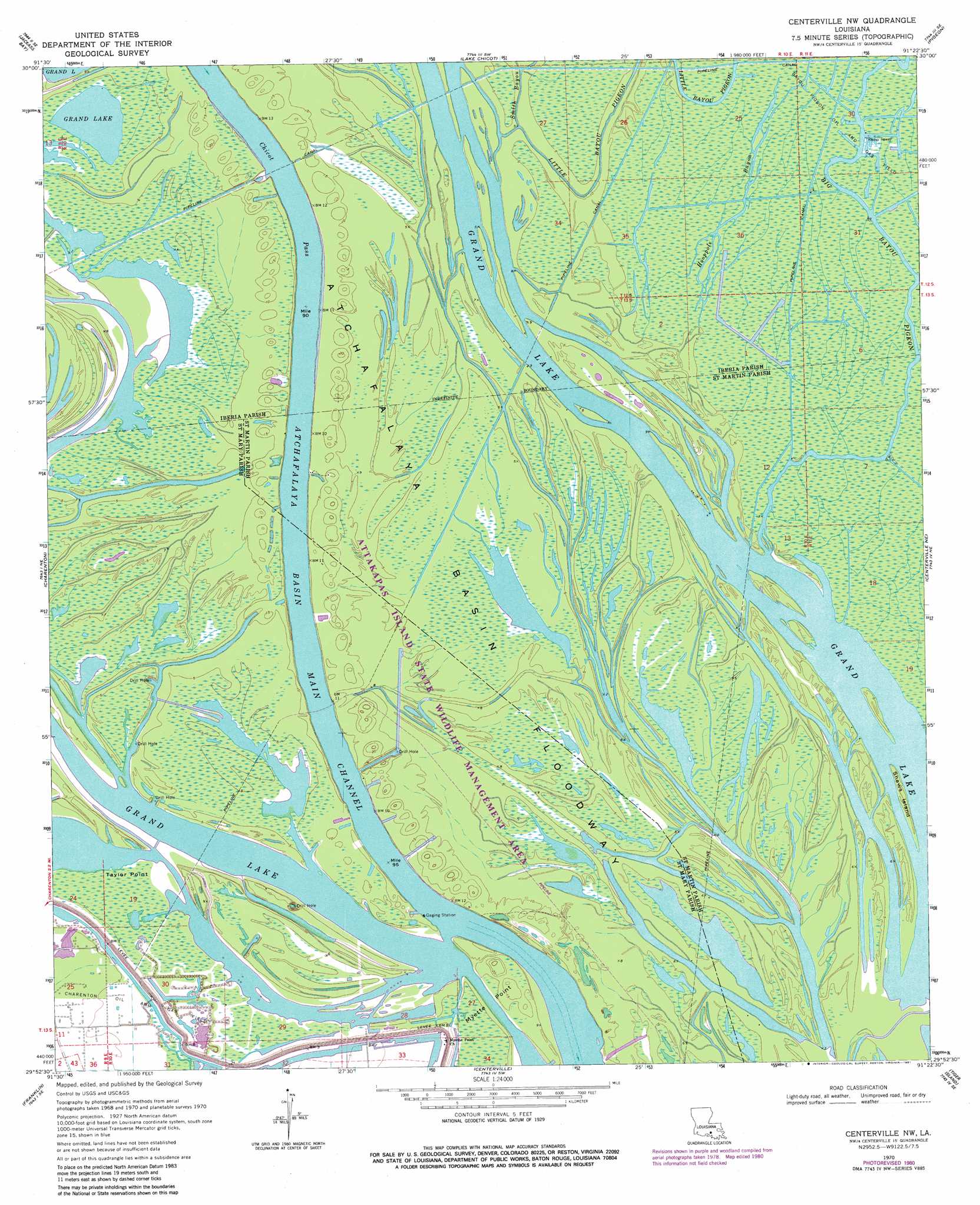
USGS Topo Quad 29091h4 - 1:24,000 scale
| Topo Map Name: | Centerville Nw |
| USGS Topo Quad ID: | 29091h4 |
| Print Size: | ca. 21 1/4" wide x 27" high |
| Southeast Coordinates: | 29.875° N latitude / 91.375° W longitude |
| Map Center Coordinates: | 29.9375° N latitude / 91.4375° W longitude |
| U.S. State: | LA |
| Filename: | o29091h4.jpg |
| Download Map JPG Image: | Centerville Nw topo map 1:24,000 scale |
| Map Type: | Topographic |
| Topo Series: | 7.5´ |
| Map Scale: | 1:24,000 |
| Source of Map Images: | United States Geological Survey (USGS) |
| Alternate Map Versions: |
Centerville NW LA 1970, updated 1971 Download PDF Buy paper map Centerville NW LA 1970, updated 1975 Download PDF Buy paper map Centerville NW LA 1970, updated 1981 Download PDF Buy paper map Centerville NW LA 2012 Download PDF Buy paper map Centerville NW LA 2015 Download PDF Buy paper map |
1:24,000 Topo Quads surrounding Centerville Nw
Catahoula |
Lake Mongoulois |
Grand River |
Bayou Sorrel |
White Castle |
Loreauville |
Jackass Bay |
Lake Chicot |
Pigeon |
Lone Star |
Jeanerette |
Charenton |
Centerville Nw |
Centerville Ne |
Pierre Part |
Kemper |
Franklin |
Centerville |
Tiger Island |
Napoleonville Sw |
Marone Point |
Ellerslie |
North Bend |
Patterson |
Morgan City |
> Back to 29091e1 at 1:100,000 scale
> Back to 29090a1 at 1:250,000 scale
> Back to U.S. Topo Maps home
Centerville Nw topo map: Gazetteer
Centerville Nw: Capes
Millet Point elevation 2m 6′Taylor Point elevation 2m 6′
Centerville Nw: Guts
Hooppole Bayou elevation 2m 6′Centerville Nw: Islands
Shaws Island elevation 1m 3′Centerville Nw: Lakes
Grand Lake elevation 1m 3′Centerville Nw: Oilfields
Charenton Oil and Gas Field elevation 1m 3′Myette Point Oil and Gas Field elevation 2m 6′
Centerville Nw: Parks
Attakapas Island State Wildlife Managment Area elevation 3m 9′Centerville Nw: Streams
Bayou Grue elevation 0m 0′Big Bayou Pigeon elevation 1m 3′
Little Bayou Pigeon elevation 1m 3′
Smith Bayou elevation 3m 9′
Centerville Nw digital topo map on disk
Buy this Centerville Nw topo map showing relief, roads, GPS coordinates and other geographical features, as a high-resolution digital map file on DVD: