Charenton Topo Map Louisiana
To zoom in, hover over the map of Charenton
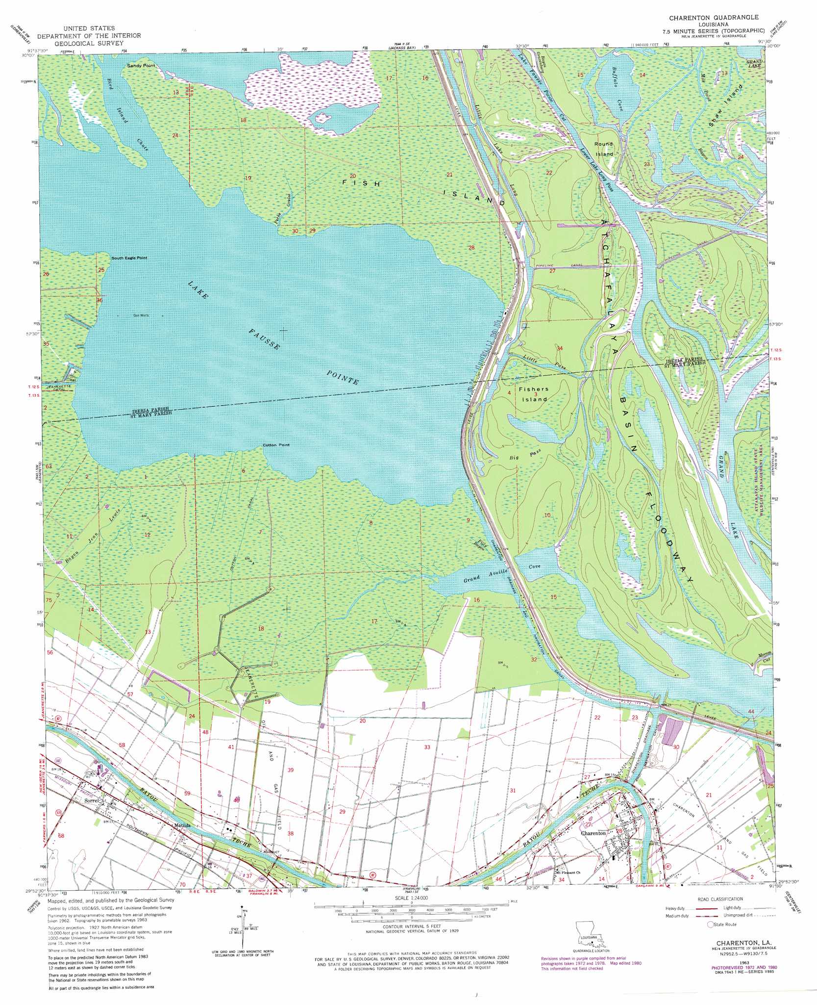
USGS Topo Quad 29091h5 - 1:24,000 scale
| Topo Map Name: | Charenton |
| USGS Topo Quad ID: | 29091h5 |
| Print Size: | ca. 21 1/4" wide x 27" high |
| Southeast Coordinates: | 29.875° N latitude / 91.5° W longitude |
| Map Center Coordinates: | 29.9375° N latitude / 91.5625° W longitude |
| U.S. State: | LA |
| Filename: | o29091h5.jpg |
| Download Map JPG Image: | Charenton topo map 1:24,000 scale |
| Map Type: | Topographic |
| Topo Series: | 7.5´ |
| Map Scale: | 1:24,000 |
| Source of Map Images: | United States Geological Survey (USGS) |
| Alternate Map Versions: |
Charenton LA 1963, updated 1964 Download PDF Buy paper map Charenton LA 1963, updated 1978 Download PDF Buy paper map Charenton LA 1963, updated 1981 Download PDF Buy paper map Charenton LA 1999, updated 2000 Download PDF Buy paper map Charenton LA 2012 Download PDF Buy paper map Charenton LA 2015 Download PDF Buy paper map |
1:24,000 Topo Quads surrounding Charenton
Parks |
Catahoula |
Lake Mongoulois |
Grand River |
Bayou Sorrel |
New Iberia North |
Loreauville |
Jackass Bay |
Lake Chicot |
Pigeon |
New Iberia South |
Jeanerette |
Charenton |
Centerville Nw |
Centerville Ne |
Weeks |
Kemper |
Franklin |
Centerville |
Tiger Island |
Hammock Lake |
Marone Point |
Ellerslie |
North Bend |
Patterson |
> Back to 29091e1 at 1:100,000 scale
> Back to 29090a1 at 1:250,000 scale
> Back to U.S. Topo Maps home
Charenton topo map: Gazetteer
Charenton: Bends
Indian Bend elevation 2m 6′Charenton: Canals
Charenton Drainage and Navigation Canal elevation 0m 0′Cotton Canal elevation 0m 0′
Charenton: Capes
Cotton Point elevation 0m 0′Sandy Point elevation 0m 0′
South Eagle Pointe elevation 0m 0′
Charenton: Channels
Big Pass elevation 2m 6′Bird Island Chute elevation 0m 0′
Little Pass elevation 2m 6′
Lower Lake Long Pass elevation 2m 6′
Mecom Cut elevation 2m 6′
West Fork Chicot Pass elevation 3m 9′
Charenton: Islands
Fish Island elevation 1m 3′Fishers Island elevation 2m 6′
Round Island elevation 2m 6′
Shaw Island elevation 2m 6′
Charenton: Lakes
Buffalo Cove elevation 3m 9′Grand Avoille Cove elevation 0m 0′
Lake Fausse Pointe elevation 0m 0′
Little Lake Long elevation 3m 9′
Charenton: Oilfields
Jeanerette Oil and Gas Field elevation 3m 9′Charenton: Populated Places
Charenton elevation 4m 13′Fish Island elevation 4m 13′
Matilda elevation 5m 16′
Netpinunsh (historical) elevation 5m 16′
Sorrel elevation 4m 13′
Charenton: Post Offices
Charenton Post Office elevation 3m 9′Cypremort Post Office elevation 4m 13′
Charenton: Streams
Bayou Gravenburg elevation 4m 13′Bayou Jean Lewis elevation 0m 0′
Filly Bayou elevation 0m 0′
Mile Point Bayou elevation 2m 6′
Peche Coulee elevation 0m 0′
Charenton digital topo map on disk
Buy this Charenton topo map showing relief, roads, GPS coordinates and other geographical features, as a high-resolution digital map file on DVD: