New Iberia South Topo Map Louisiana
To zoom in, hover over the map of New Iberia South
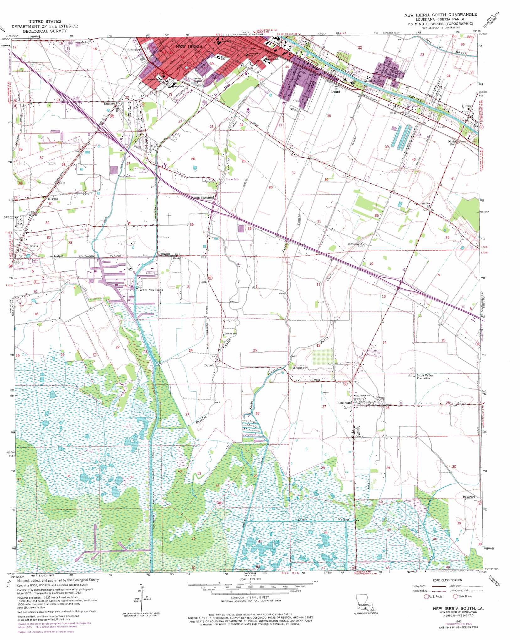
USGS Topo Quad 29091h7 - 1:24,000 scale
| Topo Map Name: | New Iberia South |
| USGS Topo Quad ID: | 29091h7 |
| Print Size: | ca. 21 1/4" wide x 27" high |
| Southeast Coordinates: | 29.875° N latitude / 91.75° W longitude |
| Map Center Coordinates: | 29.9375° N latitude / 91.8125° W longitude |
| U.S. State: | LA |
| Filename: | o29091h7.jpg |
| Download Map JPG Image: | New Iberia South topo map 1:24,000 scale |
| Map Type: | Topographic |
| Topo Series: | 7.5´ |
| Map Scale: | 1:24,000 |
| Source of Map Images: | United States Geological Survey (USGS) |
| Alternate Map Versions: |
New Iberia South LA 1963, updated 1964 Download PDF Buy paper map New Iberia South LA 1963, updated 1978 Download PDF Buy paper map New Iberia South LA 1994, updated 1998 Download PDF Buy paper map New Iberia South LA 2012 Download PDF Buy paper map New Iberia South LA 2015 Download PDF Buy paper map |
1:24,000 Topo Quads surrounding New Iberia South
Lafayette |
Broussard |
Parks |
Catahoula |
Lake Mongoulois |
Milton |
Youngsville |
New Iberia North |
Loreauville |
Jackass Bay |
Abbeville East |
Delcambre |
New Iberia South |
Jeanerette |
Charenton |
Hebert Lake |
Tigre Lagoon |
Weeks |
Kemper |
Franklin |
Redfish Point |
Cypremort Point |
Hammock Lake |
Marone Point |
Ellerslie |
> Back to 29091e1 at 1:100,000 scale
> Back to 29090a1 at 1:250,000 scale
> Back to U.S. Topo Maps home
New Iberia South topo map: Gazetteer
New Iberia South: Airports
Igh Heliport elevation 4m 13′Wilson Downhole Heliport elevation 3m 9′
New Iberia South: Areas
Prairie Au Large elevation 1m 3′New Iberia South: Canals
Armenco Branch Canal elevation 1m 3′Bayou Jack Canal elevation 1m 3′
Commercial Canal elevation 3m 9′
Nelson Canal elevation 4m 13′
New Iberia Southern Drainage Canal elevation 0m 0′
Pharr Canal elevation 4m 13′
Rodere Canal elevation 1m 3′
Weeks Canal elevation 1m 3′
New Iberia South: Oilfields
Southeast Avery Island Oil and Gas Field elevation 0m 0′New Iberia South: Populated Places
Berard elevation 6m 19′Boudreaux elevation 2m 6′
Brannon elevation 3m 9′
Davids elevation 1m 3′
Delaware elevation 2m 6′
Dennison elevation 2m 6′
Duboin elevation 2m 6′
Gajan elevation 6m 19′
Gall elevation 2m 6′
Greig elevation 2m 6′
Little Valley Plantation elevation 2m 6′
Ludger elevation 2m 6′
Lydia elevation 3m 9′
Migues elevation 2m 6′
Olivier elevation 6m 19′
Pesson elevation 1m 3′
Port of Iberia elevation 2m 6′
New Iberia South: Streams
Bodin Coulee elevation 1m 3′Jacks Coulee elevation 1m 3′
Little Valley Bayou elevation 0m 0′
Peebles Coulee elevation 2m 6′
New Iberia South digital topo map on disk
Buy this New Iberia South topo map showing relief, roads, GPS coordinates and other geographical features, as a high-resolution digital map file on DVD: