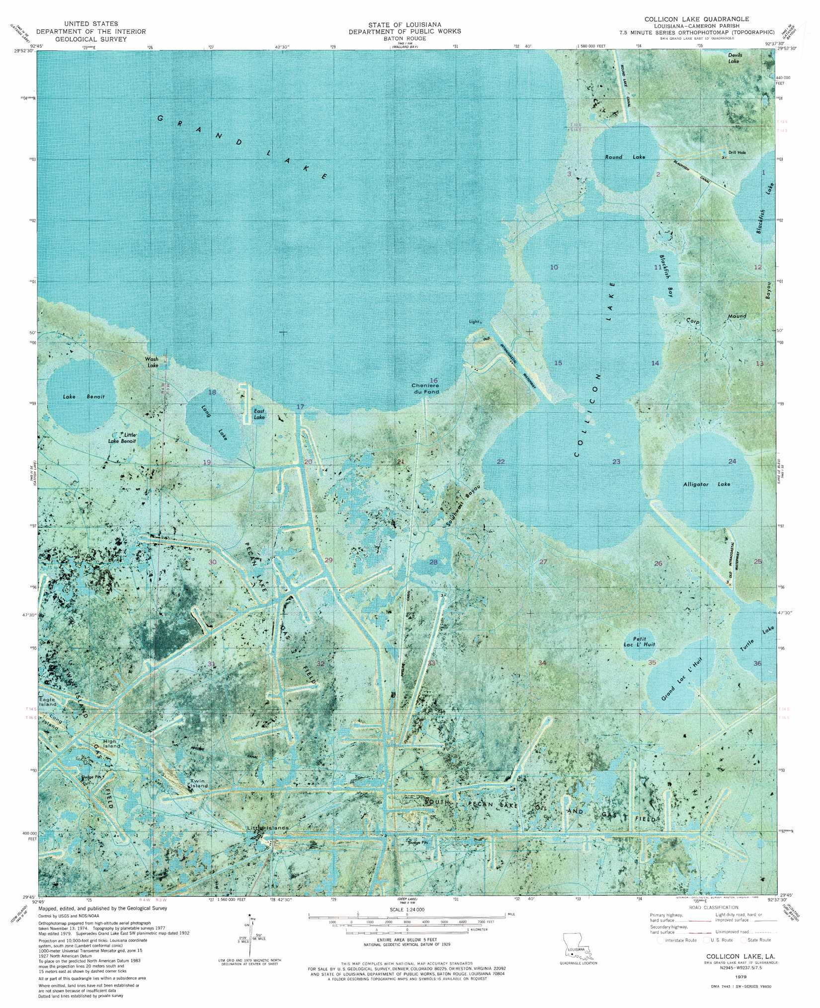
Collicon Lake Topo Map Louisiana
To zoom in, hover over the map of Collicon Lake
USGS Topo Quad 29092g6 - 1:24,000 scale
| Topo Map Name: | Collicon Lake |
| USGS Topo Quad ID: | 29092g6 |
| Print Size: | ca. 21 1/4" wide x 27" high |
| Southeast Coordinates: | 29.75° N latitude / 92.625° W longitude |
| Map Center Coordinates: | 29.8125° N latitude / 92.6875° W longitude |
| U.S. State: | LA |
| Filename: | p29092g6.jpg |
| Download Map JPG Image: | Collicon Lake topo map 1:24,000 scale |
| Map Type: | Orthophoto |
| Topo Series: | 7.5´ |
| Map Scale: | 1:24,000 |
| Source of Map Images: | United States Geological Survey (USGS) |
| Alternate Map Versions: |
Collicon Lake LA 1979, updated 1980 Download PDF Buy paper map Collicon Lake LA 2012 Download PDF Buy paper map Collicon Lake LA 2015 Download PDF Buy paper map |
1:24,000 Topo Quads surrounding Collicon Lake
Hayes |
Thornwell |
Lake Arthur |
Gueydan |
Wright |
Lake Misere |
Latania Lake |
Mallard Bay |
Latanier Bayou |
Forked Island Nw |
Grand Cheniere |
Catfish Lake |
Collicon Lake |
Lake Le Bleu |
Jacks Point Island |
Hog Bayou |
Cow Island |
Deep Lake |
Floating Turf Bayou |
Pecan Island |
Big Constance Lake |
Rollover Lake |
Mulberry Island West |
> Back to 29092e1 at 1:100,000 scale
> Back to 29092a1 at 1:250,000 scale
> Back to U.S. Topo Maps home
Collicon Lake topo map: Gazetteer
Collicon Lake: Bays
Blackfish Bay elevation -1m -4′Collicon Lake: Canals
Blackfish Canal elevation 0m 0′Round Lake Canal elevation 0m 0′
Collicon Lake: Islands
Cheniere du Fond elevation 0m 0′Eagle Island elevation 0m 0′
High Island elevation 0m 0′
Little Islands elevation 0m 0′
Twin Island elevation 0m 0′
Collicon Lake: Lakes
Alligator Lake elevation 0m 0′Collicon Lake elevation 0m 0′
East Lake elevation 0m 0′
Grand Lac L'Huit elevation -1m -4′
Lake Benoit elevation 0m 0′
Little Lake Benoit elevation 0m 0′
Long Lake elevation -2m -7′
Petit Lac L'Huit elevation -3m -10′
Round Lake elevation -1m -4′
Wash Lake elevation 0m 0′
Collicon Lake: Oilfields
Pecan Lake Gas Field elevation 0m 0′South Pecan Lake Oil and Gas Field elevation 0m 0′
Twin Island Oil Field elevation 0m 0′
Collicon Lake: Streams
Corp Mound Bayou elevation 0m 0′Southwest Bayou elevation -1m -4′
Collicon Lake digital topo map on disk
Buy this Collicon Lake topo map showing relief, roads, GPS coordinates and other geographical features, as a high-resolution digital map file on DVD: