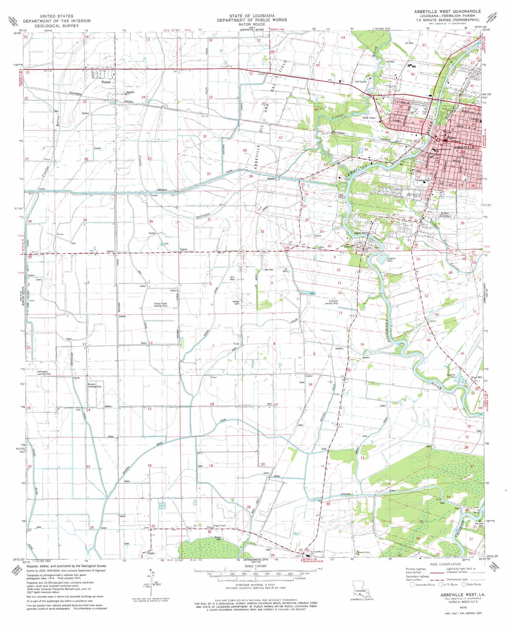
Abbeville West Topo Map Louisiana
To zoom in, hover over the map of Abbeville West
USGS Topo Quad 29092h2 - 1:24,000 scale
| Topo Map Name: | Abbeville West |
| USGS Topo Quad ID: | 29092h2 |
| Print Size: | ca. 21 1/4" wide x 27" high |
| Southeast Coordinates: | 29.875° N latitude / 92.125° W longitude |
| Map Center Coordinates: | 29.9375° N latitude / 92.1875° W longitude |
| U.S. State: | LA |
| Filename: | o29092h2.jpg |
| Download Map JPG Image: | Abbeville West topo map 1:24,000 scale |
| Map Type: | Topographic |
| Topo Series: | 7.5´ |
| Map Scale: | 1:24,000 |
| Source of Map Images: | United States Geological Survey (USGS) |
| Alternate Map Versions: |
Abbeville West LA 1975, updated 1978 Download PDF Buy paper map Abbeville West LA 1994, updated 1998 Download PDF Buy paper map Abbeville West LA 2012 Download PDF Buy paper map Abbeville West LA 2015 Download PDF Buy paper map |
1:24,000 Topo Quads surrounding Abbeville West
Crowley West |
Crowley East |
Duson |
Lafayette |
Broussard |
Wright |
Kaplan North |
Leroy |
Milton |
Youngsville |
Forked Island Nw |
Kaplan South |
Abbeville West |
Abbeville East |
Delcambre |
Jacks Point Island |
Forked Island |
Intracoastal City |
Hebert Lake |
Tigre Lagoon |
Pecan Island |
Pumpkin Islands |
Fearman Lake |
Redfish Point |
Cypremort Point |
> Back to 29092e1 at 1:100,000 scale
> Back to 29092a1 at 1:250,000 scale
> Back to U.S. Topo Maps home
Abbeville West topo map: Gazetteer
Abbeville West: Airports
Harrington Flying Service Airport elevation 3m 9′Ken Guidry Number 1 Airport elevation 2m 6′
Mouton Landing Strip elevation 1m 3′
Schriefer Airstrip elevation 2m 6′
Victory Flyers Landing Strip elevation 2m 6′
Abbeville West: Bridges
Perry Bridge elevation 1m 3′Abbeville West: Canals
Abbeville Canal elevation 3m 9′Bancker Canal elevation 1m 3′
Bill Canal elevation 1m 3′
Broussard Canal elevation 2m 6′
Bull Hole Canal elevation 1m 3′
Cow Island Number Two Canal elevation 2m 6′
Faulk Canal elevation 4m 13′
Gastinel Canal elevation 3m 9′
Hebert Canal elevation 2m 6′
Holmes Canal elevation 2m 6′
Le Boeuf Canal elevation 3m 9′
Mouton Canal elevation 2m 6′
Noel Canal elevation 2m 6′
Sorbet Canal elevation 1m 3′
Williams Canal elevation 2m 6′
Abbeville West: Crossings
Bancker Ferry elevation 1m 3′Abbeville West: Oilfields
Abbeville Oil and Gas Field elevation 3m 9′Perry Gas Field elevation 4m 13′
Abbeville West: Parks
Abbeville Commercial Historic District elevation 5m 16′Abbeville Residential Historic District elevation 3m 9′
Comeaux Park elevation 4m 13′
Magdalen Square elevation 4m 13′
Abbeville West: Populated Places
Abbeville elevation 5m 16′Mouton Cove elevation 2m 6′
Nunez elevation 3m 9′
Perry elevation 2m 6′
Rose Hill elevation 1m 3′
Theall elevation 1m 3′
Abbeville West: Post Offices
Abbeville Post Office elevation 5m 16′Abbeville West: Streams
Coulee Baton elevation 3m 9′Coulee Galleque elevation 2m 6′
Coulee Kenny elevation 1m 3′
Valcourt Coulee elevation 1m 3′
Abbeville West digital topo map on disk
Buy this Abbeville West topo map showing relief, roads, GPS coordinates and other geographical features, as a high-resolution digital map file on DVD: