Latania Lake Topo Map Louisiana
To zoom in, hover over the map of Latania Lake
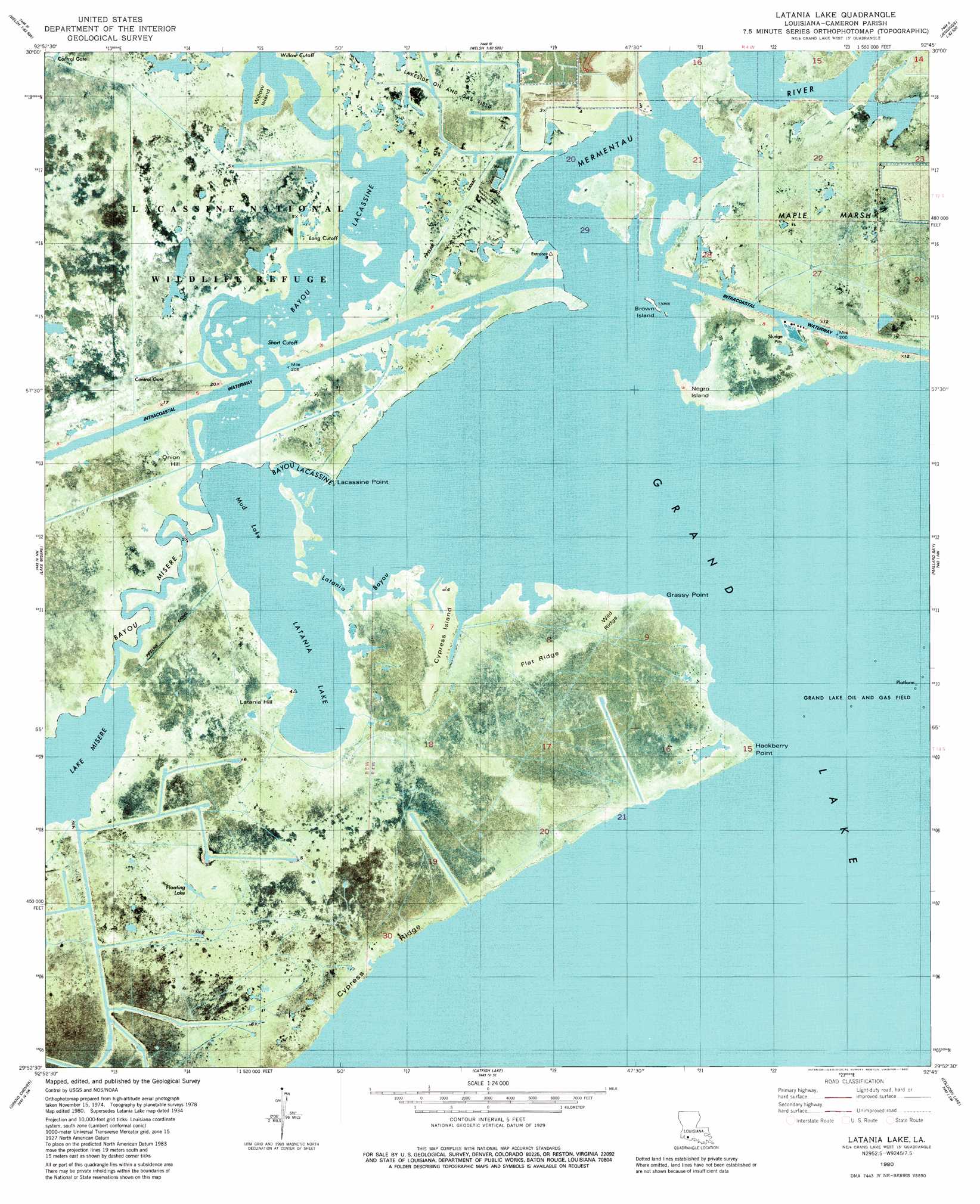
USGS Topo Quad 29092h7 - 1:24,000 scale
| Topo Map Name: | Latania Lake |
| USGS Topo Quad ID: | 29092h7 |
| Print Size: | ca. 21 1/4" wide x 27" high |
| Southeast Coordinates: | 29.875° N latitude / 92.75° W longitude |
| Map Center Coordinates: | 29.9375° N latitude / 92.8125° W longitude |
| U.S. State: | LA |
| Filename: | p29092h7.jpg |
| Download Map JPG Image: | Latania Lake topo map 1:24,000 scale |
| Map Type: | Orthophoto |
| Topo Series: | 7.5´ |
| Map Scale: | 1:24,000 |
| Source of Map Images: | United States Geological Survey (USGS) |
| Alternate Map Versions: |
Latania Lake LA 1934, updated 1961 Download PDF Buy paper map Latania Lake LA 1980, updated 1980 Download PDF Buy paper map Latania Lake LA 1980, updated 1980 Download PDF Buy paper map Latania Lake LA 2012 Download PDF Buy paper map Latania Lake LA 2015 Download PDF Buy paper map |
1:24,000 Topo Quads surrounding Latania Lake
Iowa |
Lacassine |
Welsh South |
Jennings |
Mermentau |
Lake Charles Se |
Hayes |
Thornwell |
Lake Arthur |
Gueydan |
Boudreaux Lake |
Lake Misere |
Latania Lake |
Mallard Bay |
Latanier Bayou |
Creole |
Grand Cheniere |
Catfish Lake |
Collicon Lake |
Lake Le Bleu |
Hackberry Beach |
Hog Bayou |
Cow Island |
Deep Lake |
Floating Turf Bayou |
> Back to 29092e1 at 1:100,000 scale
> Back to 29092a1 at 1:250,000 scale
> Back to U.S. Topo Maps home
Latania Lake topo map: Gazetteer
Latania Lake: Capes
Grassy Point elevation 0m 0′Hackberry Point elevation 0m 0′
Lacassine Point elevation 0m 0′
Latania Lake: Channels
Long Cutoff elevation 0m 0′Short Cutoff elevation 1m 3′
Willow Cutoff elevation 0m 0′
Latania Lake: Islands
Brown Island elevation 0m 0′Cypress Island elevation 0m 0′
Negro Island elevation 0m 0′
Willow Island elevation 1m 3′
Latania Lake: Lakes
Floating Lake elevation 1m 3′Latania Lake elevation 0m 0′
Mermentau Lake elevation 0m 0′
Mud Lake elevation 0m 0′
Latania Lake: Oilfields
Lakeside Oil and Gas Field elevation 1m 3′Perreau Island Oil Field elevation 1m 3′
South Grand Lake Gas Field elevation 0m 0′
Latania Lake: Parks
Lacassine National Wildlife Refuge elevation 0m 0′Latania Lake: Ridges
Cypress Ridge elevation 1m 3′Flat Ridge elevation 0m 0′
Wild Ridge elevation 0m 0′
Latania Lake: Streams
Bayou Lacassine elevation 0m 0′Bayou Misere elevation 0m 0′
Latania Bayou elevation 0m 0′
Latania Lake: Summits
Latania Hill elevation 0m 0′Onion Hill elevation 0m 0′
Latania Lake: Trails
Pirogue Trail elevation 0m 0′Latania Lake digital topo map on disk
Buy this Latania Lake topo map showing relief, roads, GPS coordinates and other geographical features, as a high-resolution digital map file on DVD: