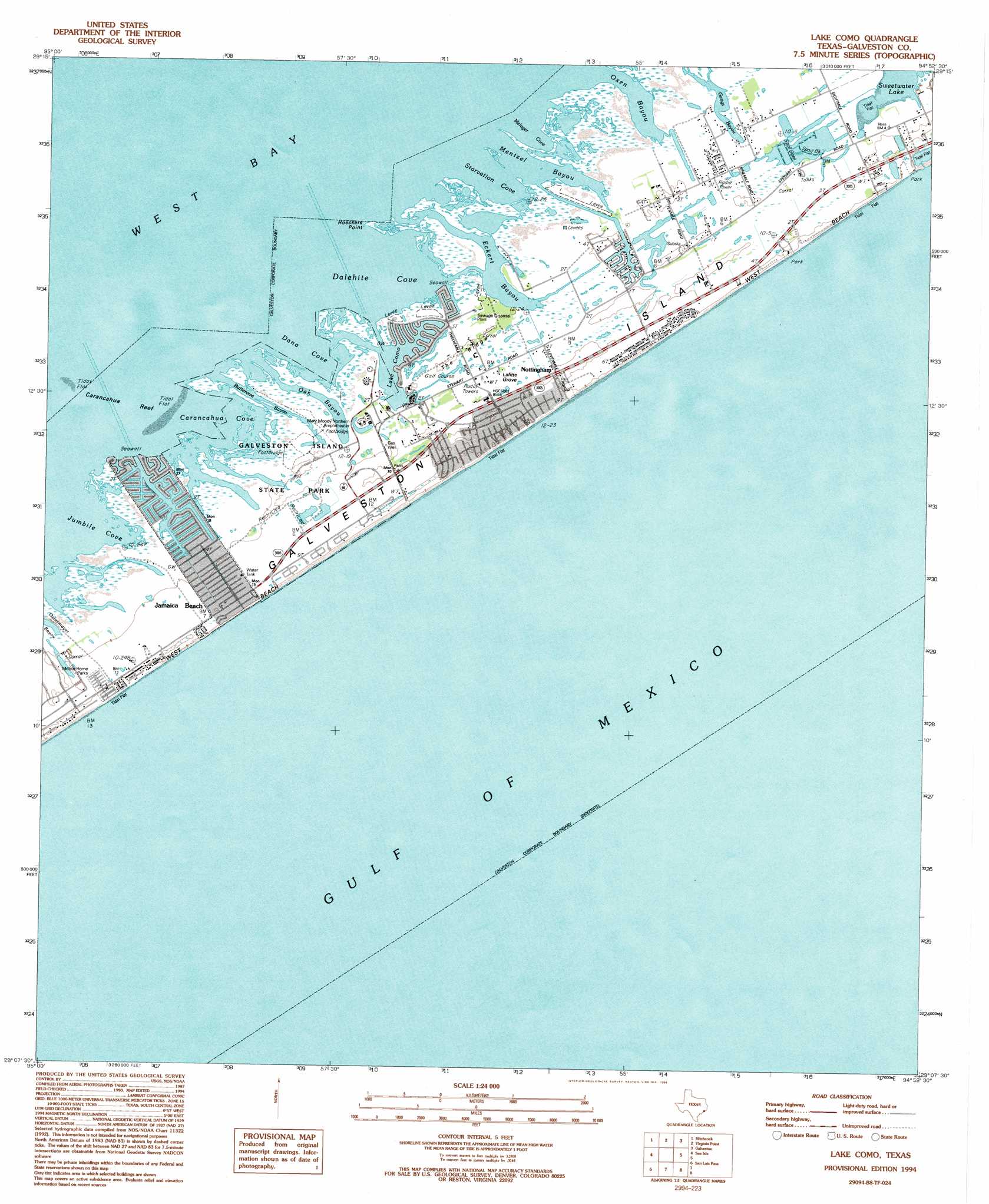
Lake Como Topo Map Texas
To zoom in, hover over the map of Lake Como
USGS Topo Quad 29094b8 - 1:24,000 scale
| Topo Map Name: | Lake Como |
| USGS Topo Quad ID: | 29094b8 |
| Print Size: | ca. 21 1/4" wide x 27" high |
| Southeast Coordinates: | 29.125° N latitude / 94.875° W longitude |
| Map Center Coordinates: | 29.1875° N latitude / 94.9375° W longitude |
| U.S. State: | TX |
| Filename: | o29094b8.jpg |
| Download Map JPG Image: | Lake Como topo map 1:24,000 scale |
| Map Type: | Topographic |
| Topo Series: | 7.5´ |
| Map Scale: | 1:24,000 |
| Source of Map Images: | United States Geological Survey (USGS) |
| Alternate Map Versions: |
Lake Como TX 1931 Download PDF Buy paper map Lake Como TX 1943, updated 1952 Download PDF Buy paper map Lake Como TX 1954, updated 1958 Download PDF Buy paper map Lake Como TX 1954, updated 1965 Download PDF Buy paper map Lake Como TX 1954, updated 1970 Download PDF Buy paper map Lake Como TX 1954, updated 1977 Download PDF Buy paper map Lake Como TX 1994, updated 1994 Download PDF Buy paper map Lake Como TX 2010 Download PDF Buy paper map Lake Como TX 2013 Download PDF Buy paper map Lake Como TX 2016 Download PDF Buy paper map |
1:24,000 Topo Quads surrounding Lake Como
Algoa |
Dickinson |
Texas City |
Port Bolivar |
Flake |
Mustang Bayou |
Hitchcock |
Virginia Point |
Galveston |
The Jetties |
Hoskins Mound |
Sea Isle |
Lake Como |
||
Christmas Point |
San Luis Pass |
|||
> Back to 29094a1 at 1:100,000 scale
> Back to 29094a1 at 1:250,000 scale
> Back to U.S. Topo Maps home
Lake Como topo map: Gazetteer
Lake Como: Areas
Nottingham elevation 3m 9′Lake Como: Bars
Carancahua Reef elevation 0m 0′Lake Como: Basins
Mary Moody Northern Amphitheater elevation 2m 6′Lake Como: Bays
Carancahua Cove elevation 0m 0′Dalehite Cove elevation 0m 0′
Dana Cove elevation 0m 0′
Pirates Cove elevation 0m 0′
Pirates Cove elevation 0m 0′
Lake Como: Beaches
Bermuda Beach elevation 2m 6′Bermuda Beach elevation 1m 3′
Jamaica Beach elevation 2m 6′
Palm Beach elevation 2m 6′
Pirates Beach elevation 2m 6′
Pirates Beach elevation 1m 3′
West Beach elevation 0m 0′
Lake Como: Capes
Hoeckers Point elevation 0m 0′Lake Como: Guts
Butterowe Bayou elevation 0m 0′Eckert Bayou elevation 0m 0′
Ganas Bayou elevation 1m 3′
Gangs Bayou elevation 0m 0′
Gangs Bayou elevation 1m 3′
Jumbile Cove elevation 0m 0′
Melager Cove elevation 0m 0′
Mentzel Bayou elevation 0m 0′
Oak Bayou elevation 0m 0′
Oxen Bayou elevation 0m 0′
Starvation Cove elevation 0m 0′
Lake Como: Islands
Galveston Island elevation 2m 6′Lake Como: Lakes
Lake Como elevation 0m 0′Lake Como: Parks
Galveston Island State Park elevation 2m 6′Sand Castle Beach Pocket Park 2 elevation 2m 6′
Sea Gull Shores Beach Pocket Park 1 elevation 2m 6′
Sea Shell Beach Pocket Park 3 elevation 0m 0′
Lake Como: Populated Places
Jamaica Beach elevation 2m 6′Lake Como: Ridges
The Ridge elevation 3m 9′Lake Como: Trails
Galveston Island State Park Trail elevation 2m 6′Lake Como: Woods
Lafitte Grove elevation 2m 6′Lake Como digital topo map on disk
Buy this Lake Como topo map showing relief, roads, GPS coordinates and other geographical features, as a high-resolution digital map file on DVD: