Big Hill Bayou Topo Map Texas
To zoom in, hover over the map of Big Hill Bayou
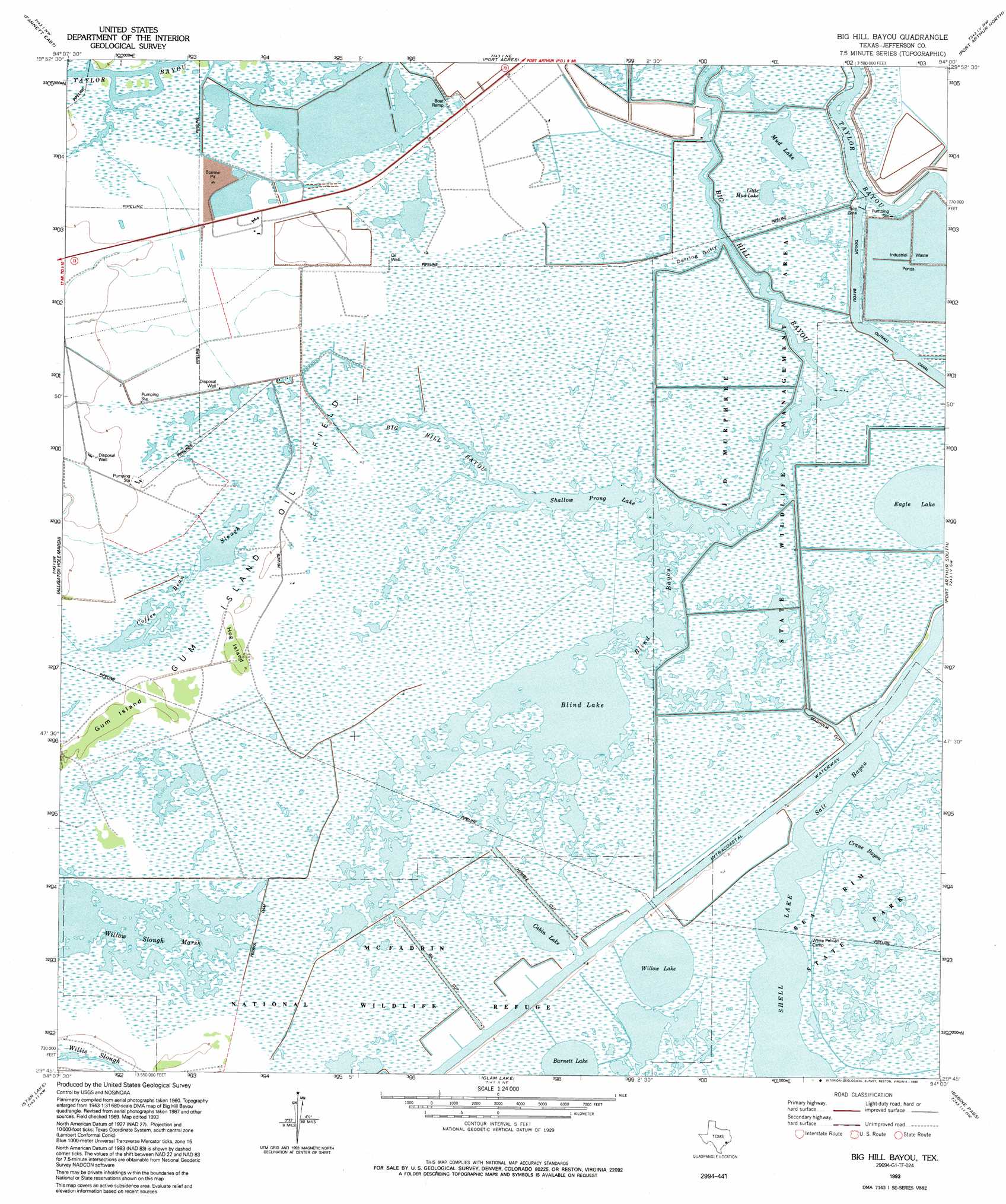
USGS Topo Quad 29094g1 - 1:24,000 scale
| Topo Map Name: | Big Hill Bayou |
| USGS Topo Quad ID: | 29094g1 |
| Print Size: | ca. 21 1/4" wide x 27" high |
| Southeast Coordinates: | 29.75° N latitude / 94° W longitude |
| Map Center Coordinates: | 29.8125° N latitude / 94.0625° W longitude |
| U.S. State: | TX |
| Filename: | o29094g1.jpg |
| Download Map JPG Image: | Big Hill Bayou topo map 1:24,000 scale |
| Map Type: | Topographic |
| Topo Series: | 7.5´ |
| Map Scale: | 1:24,000 |
| Source of Map Images: | United States Geological Survey (USGS) |
| Alternate Map Versions: |
Big Hill Bayou TX 1962, updated 1964 Download PDF Buy paper map Big Hill Bayou TX 1962, updated 1971 Download PDF Buy paper map Big Hill Bayou TX 1962, updated 1979 Download PDF Buy paper map Big Hill Bayou TX 1993, updated 1994 Download PDF Buy paper map Big Hill Bayou TX 2010 Download PDF Buy paper map Big Hill Bayou TX 2013 Download PDF Buy paper map Big Hill Bayou TX 2016 Download PDF Buy paper map |
1:24,000 Topo Quads surrounding Big Hill Bayou
China |
Beaumont West |
Beaumont East |
Terry |
Orangefield |
Fannett West |
Fannett East |
Port Acres |
Port Arthur North |
West Of Greens Bayou |
Hamshire |
Alligator Hole Marsh |
Big Hill Bayou |
Port Arthur South |
West Of Johnsons Bayou |
Whites Ranch |
Star Lake |
Clam Lake |
Sabine Pass |
Texas Point |
Mud Lake |
South Of Star Lake |
> Back to 29094e1 at 1:100,000 scale
> Back to 29094a1 at 1:250,000 scale
> Back to U.S. Topo Maps home
Big Hill Bayou topo map: Gazetteer
Big Hill Bayou: Bays
Blind Bayou elevation 2m 6′Crane Bayou elevation -1m -4′
Derring Gully elevation 2m 6′
Salt Bayou elevation 0m 0′
Big Hill Bayou: Guts
Big Hill Bayou elevation 1m 3′Big Hill Bayou: Islands
Gum Island elevation 2m 6′Hog Island elevation 2m 6′
Big Hill Bayou: Lakes
Barnett Lake elevation 1m 3′Blind Lake elevation 2m 6′
Cabin Lake elevation 1m 3′
Coffee Bean Slough elevation 2m 6′
Shallow Prong Lake elevation 2m 6′
Shell Lake elevation 0m 0′
Willow Lake elevation 1m 3′
Big Hill Bayou: Parks
Big Hill Bayou Wildlife Management Area elevation 2m 6′J D Murphee State Wildlife Management Area elevation 1m 3′
Big Hill Bayou: Reservoirs
Big Hill Reservoir elevation 2m 6′Big Hill Bayou: Swamps
Willow Slough Marsh elevation 1m 3′Big Hill Bayou digital topo map on disk
Buy this Big Hill Bayou topo map showing relief, roads, GPS coordinates and other geographical features, as a high-resolution digital map file on DVD: