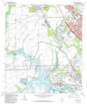
Port Acres Topo Map Texas
To zoom in, hover over the map of Port Acres
USGS Topo Quad 29094h1 - 1:24,000 scale
| Topo Map Name: | Port Acres |
| USGS Topo Quad ID: | 29094h1 |
| Print Size: | ca. 21 1/4" wide x 27" high |
| Southeast Coordinates: | 29.875° N latitude / 94° W longitude |
| Map Center Coordinates: | 29.9375° N latitude / 94.0625° W longitude |
| U.S. State: | TX |
| Filename: | o29094h1.jpg |
| Download Map JPG Image: | Port Acres topo map 1:24,000 scale |
| Map Type: | Topographic |
| Topo Series: | 7.5´ |
| Map Scale: | 1:24,000 |
| Source of Map Images: | United States Geological Survey (USGS) |
| Alternate Map Versions: |
Port Acres TX 1962, updated 1964 Download PDF Buy paper map Port Acres TX 1962, updated 1971 Download PDF Buy paper map Port Acres TX 1962, updated 1979 Download PDF Buy paper map Port Acres TX 1962, updated 1986 Download PDF Buy paper map Port Acres TX 1993, updated 1994 Download PDF Buy paper map Port Acres TX 2010 Download PDF Buy paper map Port Acres TX 2013 Download PDF Buy paper map Port Acres TX 2016 Download PDF Buy paper map |
1:24,000 Topo Quads surrounding Port Acres
> Back to 29094e1 at 1:100,000 scale
> Back to 29094a1 at 1:250,000 scale
> Back to U.S. Topo Maps home
Port Acres topo map: Gazetteer
Port Acres: Airports
Jefferson County Airport elevation 4m 13′Port Acres: Canals
Drummon Canal elevation 2m 6′Garner Canal elevation 3m 9′
Port Arthur Canal elevation 4m 13′
Port Acres: Cliffs
Smith Bluff elevation 4m 13′Port Acres: Guts
Fish Box Gully elevation 1m 3′Snake Bayou elevation 1m 3′
Tiger Bayou elevation 1m 3′
Port Acres: Islands
French Island elevation 2m 6′Port Acres: Parks
Eagles Park elevation 2m 6′Live Oak Memorial Park elevation 4m 13′
Port Acres: Populated Places
Beauxart Gardens elevation 4m 13′Central Gardens elevation 5m 16′
Hebert elevation 6m 19′
Hillebrandt elevation 2m 6′
Lucas elevation 6m 19′
Port Acres elevation 2m 6′
Viterbo elevation 5m 16′
Port Acres: Reservoirs
Viterbo Reservoir elevation 1m 3′Port Acres: Streams
Hillebrandt Bayou elevation 1m 3′Port Acres: Valleys
Johns Gully elevation 1m 3′Rhodair Gully elevation 1m 3′
Port Acres digital topo map on disk
Buy this Port Acres topo map showing relief, roads, GPS coordinates and other geographical features, as a high-resolution digital map file on DVD:


