Danbury Topo Map Texas
To zoom in, hover over the map of Danbury
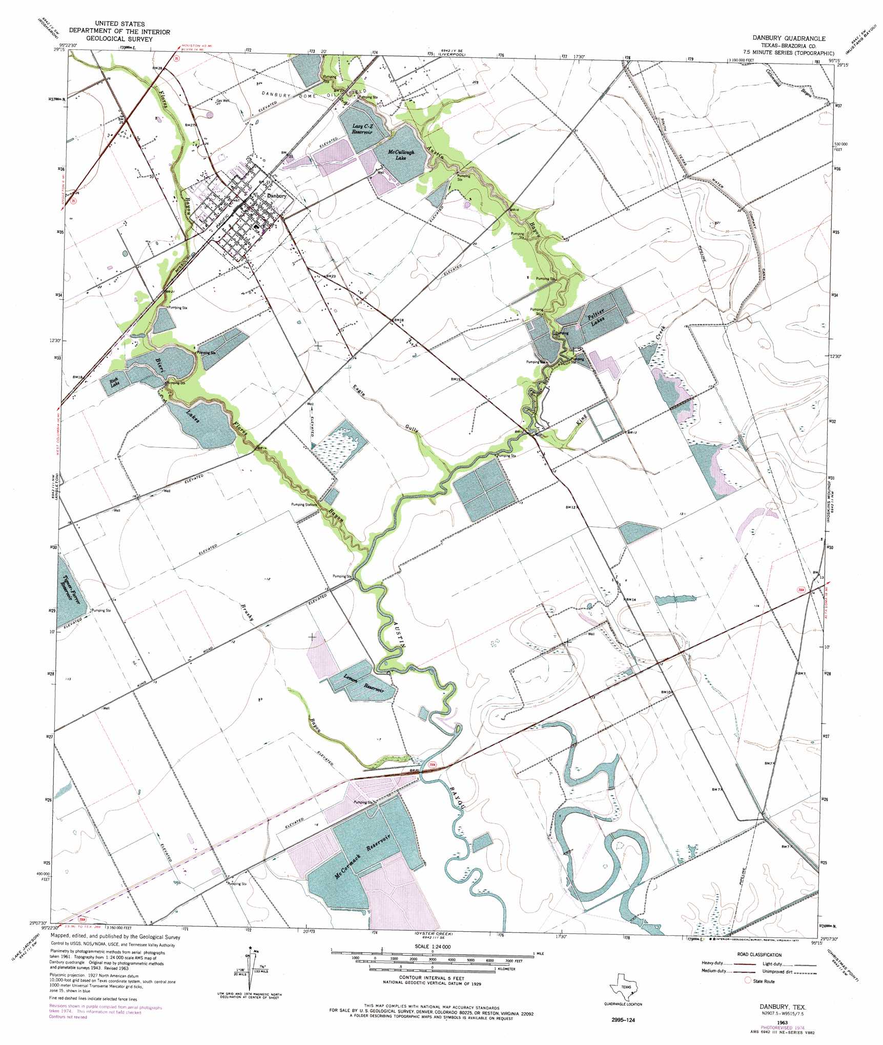
USGS Topo Quad 29095b3 - 1:24,000 scale
| Topo Map Name: | Danbury |
| USGS Topo Quad ID: | 29095b3 |
| Print Size: | ca. 21 1/4" wide x 27" high |
| Southeast Coordinates: | 29.125° N latitude / 95.25° W longitude |
| Map Center Coordinates: | 29.1875° N latitude / 95.3125° W longitude |
| U.S. State: | TX |
| Filename: | o29095b3.jpg |
| Download Map JPG Image: | Danbury topo map 1:24,000 scale |
| Map Type: | Topographic |
| Topo Series: | 7.5´ |
| Map Scale: | 1:24,000 |
| Source of Map Images: | United States Geological Survey (USGS) |
| Alternate Map Versions: |
Danbury TX 1943, updated 1959 Download PDF Buy paper map Danbury TX 1963, updated 1966 Download PDF Buy paper map Danbury TX 1963, updated 1977 Download PDF Buy paper map Danbury TX 2010 Download PDF Buy paper map Danbury TX 2013 Download PDF Buy paper map Danbury TX 2016 Download PDF Buy paper map |
1:24,000 Topo Quads surrounding Danbury
Thompsons |
Juliff |
Manvel |
Algoa |
Dickinson |
Otey |
Rosharon |
Liverpool |
Mustang Bayou |
Hitchcock |
East Columbia |
Angleton |
Danbury |
Hoskins Mound |
Sea Isle |
Brazoria |
Lake Jackson |
Oyster Creek |
Christmas Point |
San Luis Pass |
Cedar Lane Ne |
Jones Creek |
Freeport |
> Back to 29095a1 at 1:100,000 scale
> Back to 29094a1 at 1:250,000 scale
> Back to U.S. Topo Maps home
Danbury topo map: Gazetteer
Danbury: Airports
Salaika Aviation Airport elevation 7m 22′Danbury: Dams
Bieri Lake Number 1 Levee elevation 3m 9′Bieri Lake Number 2 Levee elevation 5m 16′
Bieri Lake Number 3 Levee elevation 4m 13′
Bieri Lake Number 4 Levee elevation 3m 9′
Brown Dam elevation 5m 16′
Lazy C-Z Reservoir Levee elevation 5m 16′
Lostak Lake Number 1 Levee elevation 4m 13′
McCormack Reservoir Number 1 Levee elevation 2m 6′
McCormack Reservoir Number 2 Levee elevation 2m 6′
McCormack Reservoir Number Dam elevation 2m 6′
McCullough Lake Levee elevation 5m 16′
Reservoir Number 10 Levee/Complex Number 2 Dam elevation 5m 16′
Reservoir Number 17 Levee/McCullough Reservoir Complex Dam elevation 5m 16′
Reservoir Number 18 Levee/McCullough Reservoir Complex Dam elevation 5m 16′
Reservoir Number 8 Levee/Complex Number 2 Dam elevation 6m 19′
Reservoir Number 9 Levee/Complex Number 2 Dam elevation 6m 19′
Danbury: Lakes
Bieri Lakes elevation 4m 13′McCullough Lake elevation 5m 16′
Peltier Lakes elevation 4m 13′
Rich Lake elevation 5m 16′
Danbury: Oilfields
Danbury Dome Oil Field elevation 7m 22′Danbury: Populated Places
Danbury elevation 7m 22′Danbury: Reservoirs
Bieri Lake Number 1 elevation 3m 9′Bieri Lake Number 2 elevation 5m 16′
Bieri Lake Number 3 elevation 4m 13′
Bieri Lake Number 4 elevation 3m 9′
Brown Lake elevation 5m 16′
Lazy C-Z Reservoir elevation 5m 16′
Lemon Reservoir elevation 2m 6′
Lostak Lake Number 1 elevation 4m 13′
McCormack Reservoir elevation 3m 9′
McCormack Reservoir Number 1 elevation 2m 6′
McCormack Reservoir Number 2 elevation 2m 6′
McCormack Reservoir Number 3 elevation 2m 6′
Reservoir Number 10 elevation 5m 16′
Reservoir Number 17 elevation 5m 16′
Reservoir Number 18 elevation 5m 16′
Reservoir Number 23 elevation 5m 16′
Reservoir Number 8 elevation 6m 19′
Reservoir Number 9 elevation 6m 19′
Tigner-Farrer Reservoir elevation 5m 16′
Danbury: Streams
Brushy Bayou elevation 2m 6′Flores Bayou elevation 1m 3′
King Creek elevation 2m 6′
Danbury: Valleys
Eagle Gully elevation 1m 3′Danbury digital topo map on disk
Buy this Danbury topo map showing relief, roads, GPS coordinates and other geographical features, as a high-resolution digital map file on DVD: