Mustang Bayou Topo Map Texas
To zoom in, hover over the map of Mustang Bayou
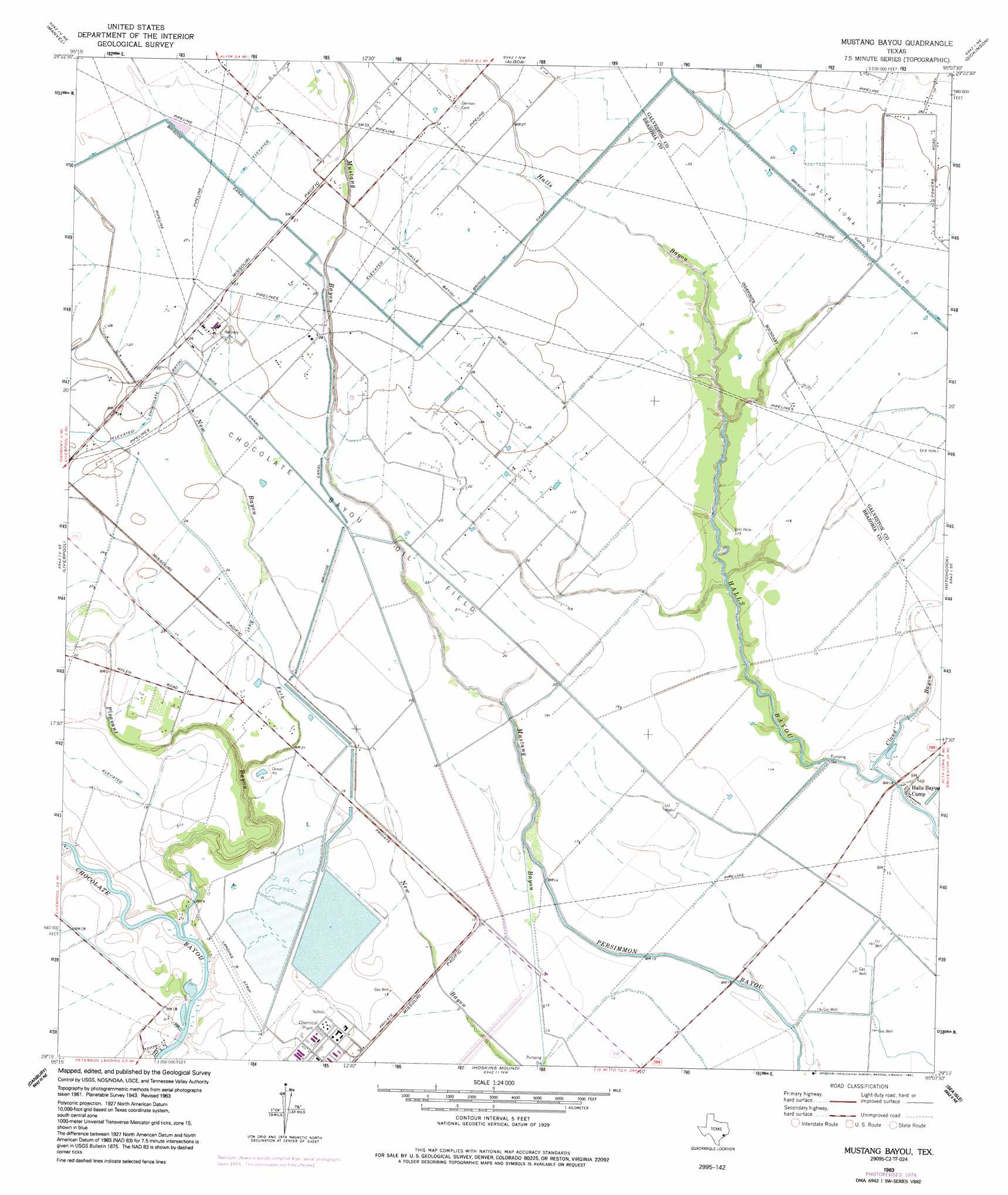
USGS Topo Quad 29095c2 - 1:24,000 scale
| Topo Map Name: | Mustang Bayou |
| USGS Topo Quad ID: | 29095c2 |
| Print Size: | ca. 21 1/4" wide x 27" high |
| Southeast Coordinates: | 29.25° N latitude / 95.125° W longitude |
| Map Center Coordinates: | 29.3125° N latitude / 95.1875° W longitude |
| U.S. State: | TX |
| Filename: | o29095c2.jpg |
| Download Map JPG Image: | Mustang Bayou topo map 1:24,000 scale |
| Map Type: | Topographic |
| Topo Series: | 7.5´ |
| Map Scale: | 1:24,000 |
| Source of Map Images: | United States Geological Survey (USGS) |
| Alternate Map Versions: |
Mustang Bayou TX 1929 Download PDF Buy paper map Mustang Bayou TX 1943, updated 1959 Download PDF Buy paper map Mustang Bayou TX 1963, updated 1966 Download PDF Buy paper map Mustang Bayou TX 1963, updated 1977 Download PDF Buy paper map Mustang Bayou TX 1963, updated 1991 Download PDF Buy paper map Mustang Bayou TX 2010 Download PDF Buy paper map Mustang Bayou TX 2013 Download PDF Buy paper map Mustang Bayou TX 2016 Download PDF Buy paper map |
1:24,000 Topo Quads surrounding Mustang Bayou
Almeda |
Pearland |
Friendswood |
League City |
Bacliff |
Juliff |
Manvel |
Algoa |
Dickinson |
Texas City |
Rosharon |
Liverpool |
Mustang Bayou |
Hitchcock |
Virginia Point |
Angleton |
Danbury |
Hoskins Mound |
Sea Isle |
Lake Como |
Lake Jackson |
Oyster Creek |
Christmas Point |
San Luis Pass |
> Back to 29095a1 at 1:100,000 scale
> Back to 29094a1 at 1:250,000 scale
> Back to U.S. Topo Maps home
Mustang Bayou topo map: Gazetteer
Mustang Bayou: Canals
Chocolate Bayou Rice Canal elevation 8m 26′Mustang Bayou: Dams
Duck Lake Dam elevation 5m 16′Monsanto Reservoir Levee elevation 5m 16′
Mustang Lake East Dam elevation 6m 19′
Mustang Lake West Dam elevation 5m 16′
Mustang Bayou: Guts
Persimmon Bayou elevation 0m 0′Mustang Bayou: Oilfields
Chocolate Bayou Oil Field elevation 6m 19′Mustang Bayou: Reservoirs
Duck Lake elevation 5m 16′Monsanto Reservoir elevation 5m 16′
Mustang Lake East elevation 6m 19′
Mustang Lake West elevation 5m 16′
Mustang Bayou: Streams
Cloud Bayou elevation 1m 3′East Fork Pleasant Bayou elevation 1m 3′
Pleasant Bayou elevation 1m 3′
Mustang Bayou digital topo map on disk
Buy this Mustang Bayou topo map showing relief, roads, GPS coordinates and other geographical features, as a high-resolution digital map file on DVD: