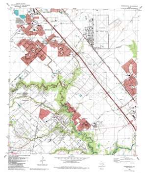
Friendswood Topo Map Texas
To zoom in, hover over the map of Friendswood
USGS Topo Quad 29095e2 - 1:24,000 scale
| Topo Map Name: | Friendswood |
| USGS Topo Quad ID: | 29095e2 |
| Print Size: | ca. 21 1/4" wide x 27" high |
| Southeast Coordinates: | 29.5° N latitude / 95.125° W longitude |
| Map Center Coordinates: | 29.5625° N latitude / 95.1875° W longitude |
| U.S. State: | TX |
| Filename: | o29095e2.jpg |
| Download Map JPG Image: | Friendswood topo map 1:24,000 scale |
| Map Type: | Topographic |
| Topo Series: | 7.5´ |
| Map Scale: | 1:24,000 |
| Source of Map Images: | United States Geological Survey (USGS) |
| Alternate Map Versions: |
Genoa TX 1916 Download PDF Buy paper map Genoa TX 1916 Download PDF Buy paper map Genoa TX 1929 Download PDF Buy paper map Friendswood TX 1955, updated 1957 Download PDF Buy paper map Friendswood TX 1955, updated 1968 Download PDF Buy paper map Friendswood TX 1955, updated 1970 Download PDF Buy paper map Freindswood TX 1982, updated 1983 Download PDF Buy paper map Friendswood TX 1982, updated 1983 Download PDF Buy paper map Friendswood TX 1995, updated 1999 Download PDF Buy paper map Friendswood TX 2010 Download PDF Buy paper map Friendswood TX 2013 Download PDF Buy paper map Friendswood TX 2016 Download PDF Buy paper map |
1:24,000 Topo Quads surrounding Friendswood
> Back to 29095e1 at 1:100,000 scale
> Back to 29094a1 at 1:250,000 scale
> Back to U.S. Topo Maps home
Friendswood topo map: Gazetteer
Friendswood: Airports
Clover Field elevation 13m 42′Club House Number 1 Heliport elevation 13m 42′
Ellington Field elevation 10m 32′
Polly Ranch Airport elevation 8m 26′
Friendswood: Crossings
Interchange 25 elevation 10m 32′Interchange 26 elevation 9m 29′
Interchange 27 elevation 10m 32′
Interchange 29 elevation 11m 36′
Interchange 30 elevation 12m 39′
Interchange 32 elevation 11m 36′
Interchange 33 elevation 16m 52′
Friendswood: Oilfields
Friendswood Oil Field elevation 10m 32′Friendswood: Parks
1776 Park elevation 7m 22′Beverly Hills Park elevation 14m 45′
Challenger 7 Memorial Park elevation 5m 16′
Friendswood City Park elevation 8m 26′
Friendswood High School Baseball Field elevation 10m 32′
Friendswood High School Softball Field elevation 10m 32′
Gulf Palms Park elevation 12m 39′
Henry Winston Stadium elevation 10m 32′
Heritage Park elevation 9m 29′
Randolph Park elevation 8m 26′
Renwick Park elevation 10m 32′
Sagemeadow Park elevation 11m 36′
San Jacinto College South Baseball Field elevation 11m 36′
Sterling Knoll Park elevation 10m 32′
Stevenson Park elevation 8m 26′
Friendswood: Populated Places
Analea White Hall elevation 10m 32′Baker Editions elevation 6m 19′
Bay Glen elevation 7m 22′
Bay Knoll elevation 8m 26′
Bay Point elevation 6m 19′
Baybrook Village elevation 9m 29′
Bradley Meadows elevation 9m 29′
Briarwood States elevation 11m 36′
Brook Meadows elevation 8m 26′
Brown Acres elevation 9m 29′
Camino South elevation 8m 26′
Clear Lake elevation 8m 26′
Clover Acres elevation 10m 32′
Dixie Hollow elevation 11m 36′
Eagles Point elevation 8m 26′
Enchanted Woods elevation 8m 26′
Fieldcrest Forest elevation 7m 22′
Forest Green elevation 8m 26′
Forestwood elevation 8m 26′
Fox Meadows elevation 7m 22′
Frenchmans Creek elevation 6m 19′
Friendswood elevation 10m 32′
Friendswood Crossing elevation 8m 26′
Friendswood Estates elevation 11m 36′
Friendswood Gardens elevation 9m 29′
Genoa elevation 13m 42′
Glenshannon elevation 10m 32′
Goldman Acres elevation 10m 32′
Green Tree Terrace elevation 12m 39′
Greenbriar elevation 9m 29′
Heritage Estates elevation 9m 29′
Highland Meadows elevation 11m 36′
Humble Camp elevation 11m 36′
Imperial Estates elevation 8m 26′
Imperial Gardens elevation 8m 26′
Keystone Meadows elevation 8m 26′
Kirkwood elevation 12m 39′
Laurelfield elevation 8m 26′
Liberty Estates elevation 7m 22′
Longwood Park elevation 11m 36′
Lori Woods elevation 9m 29′
Marys Creek Estates elevation 9m 29′
Melody Estates elevation 10m 32′
Melody Wood elevation 10m 32′
Mustang Meadows elevation 11m 36′
Nasawood elevation 11m 36′
North Fork elevation 6m 19′
Oak Brook West elevation 6m 19′
Olcott elevation 8m 26′
Orchard elevation 9m 29′
Park Place elevation 8m 26′
Parkwood Village elevation 8m 26′
Perry Grove elevation 9m 29′
Pineshadows elevation 13m 42′
Pipers Meadow elevation 10m 32′
Polly Oaks elevation 7m 22′
Polly Ranch Estates elevation 7m 22′
Poole elevation 9m 29′
Quaker Landing elevation 6m 19′
Quaker Village elevation 9m 29′
Reese Estates elevation 8m 26′
Regal Oaks elevation 13m 42′
Regency Estates elevation 8m 26′
Riverwalk elevation 10m 32′
Rustic Oaks elevation 14m 45′
Sageglen elevation 11m 36′
Sagemeadow elevation 12m 39′
Sagemont elevation 11m 36′
Sagemont Park elevation 12m 39′
Scarsdale elevation 11m 36′
Sheeran Estates elevation 9m 29′
Sleepy Hollow elevation 11m 36′
South Bend elevation 10m 32′
Sterling Knoll elevation 10m 32′
Sterling Wood elevation 7m 22′
Sunpark elevation 8m 26′
Sunset Meadows elevation 10m 32′
Sunwood elevation 8m 26′
The Forest elevation 9m 29′
Village Green elevation 10m 32′
Wilderness Trails elevation 10m 32′
Winding Way Estates elevation 8m 26′
Woodcreek elevation 12m 39′
Woodmeadow elevation 10m 32′
Friendswood: Streams
Chigger Creek elevation 1m 3′Cowart Creek elevation 2m 6′
Marys Creek elevation 3m 9′
Turkey Creek elevation 2m 6′
Friendswood: Valleys
Cedar Gully elevation 3m 9′Friendswood digital topo map on disk
Buy this Friendswood topo map showing relief, roads, GPS coordinates and other geographical features, as a high-resolution digital map file on DVD:


