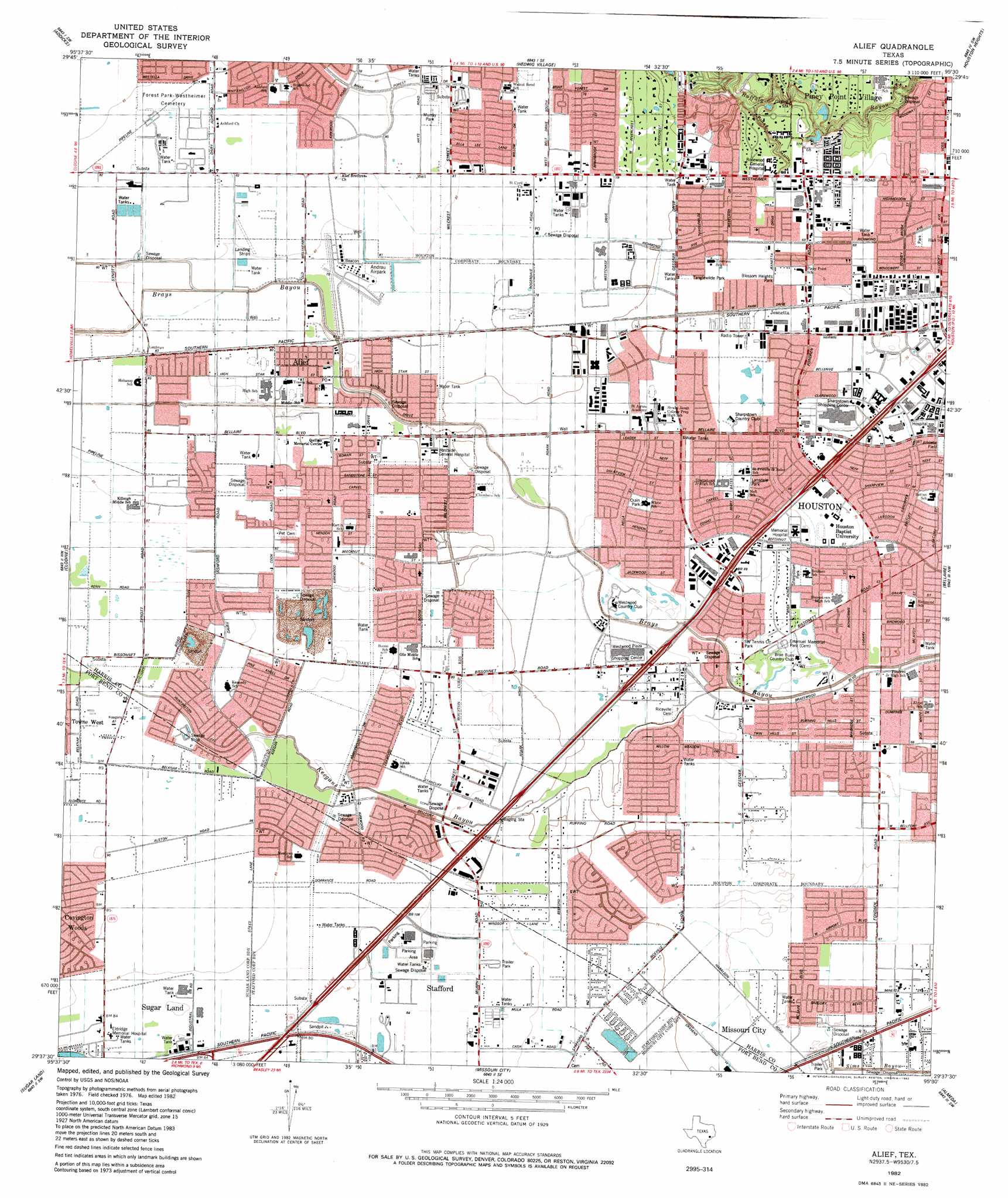
Alief Topo Map Texas
To zoom in, hover over the map of Alief
USGS Topo Quad 29095f5 - 1:24,000 scale
| Topo Map Name: | Alief |
| USGS Topo Quad ID: | 29095f5 |
| Print Size: | ca. 21 1/4" wide x 27" high |
| Southeast Coordinates: | 29.625° N latitude / 95.5° W longitude |
| Map Center Coordinates: | 29.6875° N latitude / 95.5625° W longitude |
| U.S. State: | TX |
| Filename: | o29095f5.jpg |
| Download Map JPG Image: | Alief topo map 1:24,000 scale |
| Map Type: | Topographic |
| Topo Series: | 7.5´ |
| Map Scale: | 1:24,000 |
| Source of Map Images: | United States Geological Survey (USGS) |
| Alternate Map Versions: |
Alief TX 1915 Download PDF Buy paper map Alief TX 1915 Download PDF Buy paper map Alief TX 1915, updated 1961 Download PDF Buy paper map Alief TX 1970, updated 1973 Download PDF Buy paper map Alief TX 1982, updated 1982 Download PDF Buy paper map Alief TX 1982, updated 1982 Download PDF Buy paper map Alief TX 1995, updated 1998 Download PDF Buy paper map Alief TX 2010 Download PDF Buy paper map Alief TX 2013 Download PDF Buy paper map Alief TX 2016 Download PDF Buy paper map |
1:24,000 Topo Quads surrounding Alief
Warren Lake |
Cypress |
Satsuma |
Aldine |
Humble |
Katy |
Addicks |
Hedwig Village |
Houston Heights |
Settegast |
Richmond Ne |
Clodine |
Alief |
Bellaire |
Park Place |
Richmond |
Sugar Land |
Missouri City |
Almeda |
Pearland |
Needville |
Smithers Lake |
Thompsons |
Juliff |
Manvel |
> Back to 29095e1 at 1:100,000 scale
> Back to 29094a1 at 1:250,000 scale
> Back to U.S. Topo Maps home
Alief topo map: Gazetteer
Alief: Airports
Andrau Airpark (historical) elevation 23m 75′AVSI-Sugar Land Heliport elevation 26m 85′
B and S Warehouse Heliport elevation 22m 72′
Ball Park Heliport elevation 26m 85′
Channel Two Heliport elevation 23m 75′
First Bank Plaza Garage Heliport elevation 20m 65′
G H Hart Number 2 Heliport elevation 24m 78′
Sugar Grove Heliport elevation 26m 85′
West Houston Medical Center Heliport elevation 24m 78′
Westchase Heliport elevation 23m 75′
You Asked for It-You Got It Heliport elevation 23m 75′
Alief: Parks
Blossom Heights Park elevation 22m 72′Braeburn Glen Park elevation 20m 65′
Briar Meadow Park elevation 21m 68′
Crain Park elevation 22m 72′
Crump Stadium elevation 24m 78′
Crusader Baseball Stadium elevation 22m 72′
Elsik High School Baseball Field elevation 24m 78′
Fondren Park elevation 21m 68′
Hastings High School Baseball Field elevation 24m 78′
Hastings High School Football Stadium elevation 24m 78′
Lansdale Park elevation 21m 68′
Murray Park elevation 24m 78′
Ron Slockett Park elevation 27m 88′
Sharpstown High School Baseball Field elevation 20m 65′
Sharpstown Park elevation 21m 68′
Southwest Indoor Soccer Center elevation 25m 82′
Strake Jesuit Stadium elevation 22m 72′
Tanglewilde Park elevation 23m 75′
The Kincaid School Baseball Field elevation 19m 62′
The Kincaid School Football and Track Field elevation 20m 65′
Alief: Populated Places
Alief elevation 24m 78′Ashford Park elevation 25m 82′
Ashford Village elevation 25m 82′
Beechnut Crossing elevation 26m 85′
Bellaire West elevation 23m 75′
Braeburn Glen elevation 21m 68′
Brays Village East elevation 23m 75′
Catalina Village elevation 26m 85′
Commerce Park elevation 21m 68′
Covington West elevation 27m 88′
Fondren Center elevation 20m 65′
Fondren Grove elevation 23m 75′
Fondren Southwest elevation 20m 65′
Gessport elevation 22m 72′
Glenshannon elevation 23m 75′
Greenbrier Southwest elevation 25m 82′
Grove West elevation 25m 82′
Jeanetta elevation 22m 72′
Leewood West elevation 25m 82′
Main Street Gardens elevation 21m 68′
Meadows Place elevation 26m 85′
Missouri City Estates elevation 24m 78′
Northbrook elevation 20m 65′
Northfield elevation 20m 65′
Oak Harbor elevation 25m 82′
Park Glen West elevation 25m 82′
Pheasant Run elevation 26m 85′
Rivercrest elevation 23m 75′
Rodeo Square elevation 24m 78′
Sharpstown elevation 20m 65′
Southwood Place elevation 20m 65′
The Oaks of Woodlake elevation 23m 75′
Townpark elevation 23m 75′
Two Worlds elevation 25m 82′
Vacarro Manor elevation 23m 75′
West Crest elevation 24m 78′
Westhampton Place elevation 23m 75′
Westpark Village elevation 25m 82′
Alief: Streams
Keegans Bayou elevation 14m 45′Alief: Trails
Ashford Elementary SPARK Park Trail elevation 24m 78′Collins Elementary SPARK Park Trail elevation 23m 75′
Crain Park Trail elevation 22m 72′
Emerson Elementary SPARK Park Trail elevation 22m 72′
McNamara Elementary SPARK Park Trail elevation 19m 62′
Milne Elementary SPARK Park Trail elevation 20m 65′
Piney Point Elementary SPARK Park Trail elevation 21m 68′
Sharpstown High School SPARK Park Trail elevation 20m 65′
Sharpstown Middle School SPARK Park Trail elevation 22m 72′
Sugar Grove Elementary SPARK Park Trail elevation 20m 65′
Sutton Elementary SPARK Park Trail elevation 20m 65′
Tinsley Elementary SPARK Park Trail elevation 20m 65′
White Elementary SPARK Park Trail elevation 22m 72′
Alief: Valleys
Piney Point Gully elevation 13m 42′Alief digital topo map on disk
Buy this Alief topo map showing relief, roads, GPS coordinates and other geographical features, as a high-resolution digital map file on DVD: