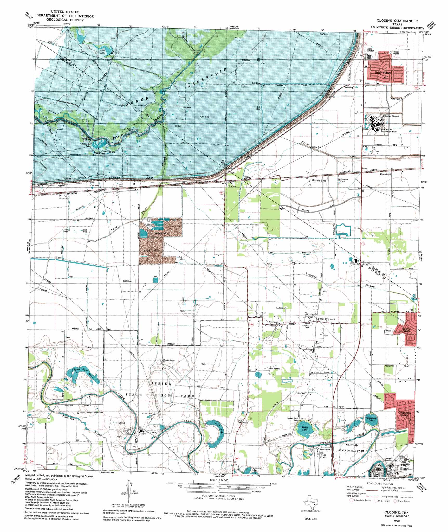
Clodine Topo Map Texas
To zoom in, hover over the map of Clodine
USGS Topo Quad 29095f6 - 1:24,000 scale
| Topo Map Name: | Clodine |
| USGS Topo Quad ID: | 29095f6 |
| Print Size: | ca. 21 1/4" wide x 27" high |
| Southeast Coordinates: | 29.625° N latitude / 95.625° W longitude |
| Map Center Coordinates: | 29.6875° N latitude / 95.6875° W longitude |
| U.S. State: | TX |
| Filename: | o29095f6.jpg |
| Download Map JPG Image: | Clodine topo map 1:24,000 scale |
| Map Type: | Topographic |
| Topo Series: | 7.5´ |
| Map Scale: | 1:24,000 |
| Source of Map Images: | United States Geological Survey (USGS) |
| Alternate Map Versions: |
Clodine TX 1915 Download PDF Buy paper map Clodine TX 1915 Download PDF Buy paper map Clodine TX 1915, updated 1961 Download PDF Buy paper map Clodine TX 1970, updated 1973 Download PDF Buy paper map Clodine TX 1982, updated 1982 Download PDF Buy paper map Clodine TX 1995, updated 1999 Download PDF Buy paper map Clodine TX 2010 Download PDF Buy paper map Clodine TX 2013 Download PDF Buy paper map Clodine TX 2016 Download PDF Buy paper map |
1:24,000 Topo Quads surrounding Clodine
Hockley Mound |
Warren Lake |
Cypress |
Satsuma |
Aldine |
Brookshire |
Katy |
Addicks |
Hedwig Village |
Houston Heights |
Fulshear |
Richmond Ne |
Clodine |
Alief |
Bellaire |
Orchard |
Richmond |
Sugar Land |
Missouri City |
Almeda |
Kendleton |
Needville |
Smithers Lake |
Thompsons |
Juliff |
> Back to 29095e1 at 1:100,000 scale
> Back to 29094a1 at 1:250,000 scale
> Back to U.S. Topo Maps home
Clodine topo map: Gazetteer
Clodine: Dams
Fort Bend Company WCID 1 Harlem Prison Dam elevation 22m 72′Clodine: Lakes
Figure Four Lake elevation 26m 85′Fish Lake elevation 24m 78′
Gannoway Lake elevation 23m 75′
White Lake elevation 24m 78′
Clodine: Parks
Austin High School Baseball Field elevation 25m 82′Austin High School Football Field and Track elevation 25m 82′
Austin High School Softball Field elevation 25m 82′
Kempner High School Baseball Field elevation 26m 85′
Kempner Stadium elevation 26m 85′
Sardar Patel Stadium elevation 28m 91′
Sugar Mill Park elevation 25m 82′
Clodine: Populated Places
Chelsea at Mission Bend elevation 29m 95′Clayton Park elevation 27m 88′
Clodine elevation 29m 95′
Dover elevation 27m 88′
Forest Wood elevation 28m 91′
Four Corners elevation 28m 91′
Hidden Lake Estates elevation 25m 82′
Kings Landing elevation 27m 88′
Mission Bend elevation 27m 88′
Mission Bend elevation 29m 95′
Mission Bend South elevation 28m 91′
Mission Glen elevation 28m 91′
Mission Green North elevation 29m 95′
Mission West elevation 29m 95′
Oak Park Trails elevation 34m 111′
Park Ridge elevation 30m 98′
Parkhollow Place elevation 25m 82′
Pecan Grove elevation 25m 82′
Pheasant Creek elevation 26m 85′
Providence elevation 27m 88′
Ragus Lake Estates elevation 26m 85′
San Miguel elevation 29m 95′
Shiloh Lake Estates elevation 25m 82′
Stratford Park elevation 25m 82′
Summerfield elevation 25m 82′
Town West elevation 27m 88′
Village of Oak Lakes elevation 25m 82′
Waterford elevation 28m 91′
West Hollow Park elevation 25m 82′
West Oaks Village elevation 29m 95′
West Wind elevation 25m 82′
Clodine: Streams
Mason Creek elevation 26m 85′Clodine: Valleys
Red Gully elevation 24m 78′Clodine digital topo map on disk
Buy this Clodine topo map showing relief, roads, GPS coordinates and other geographical features, as a high-resolution digital map file on DVD: