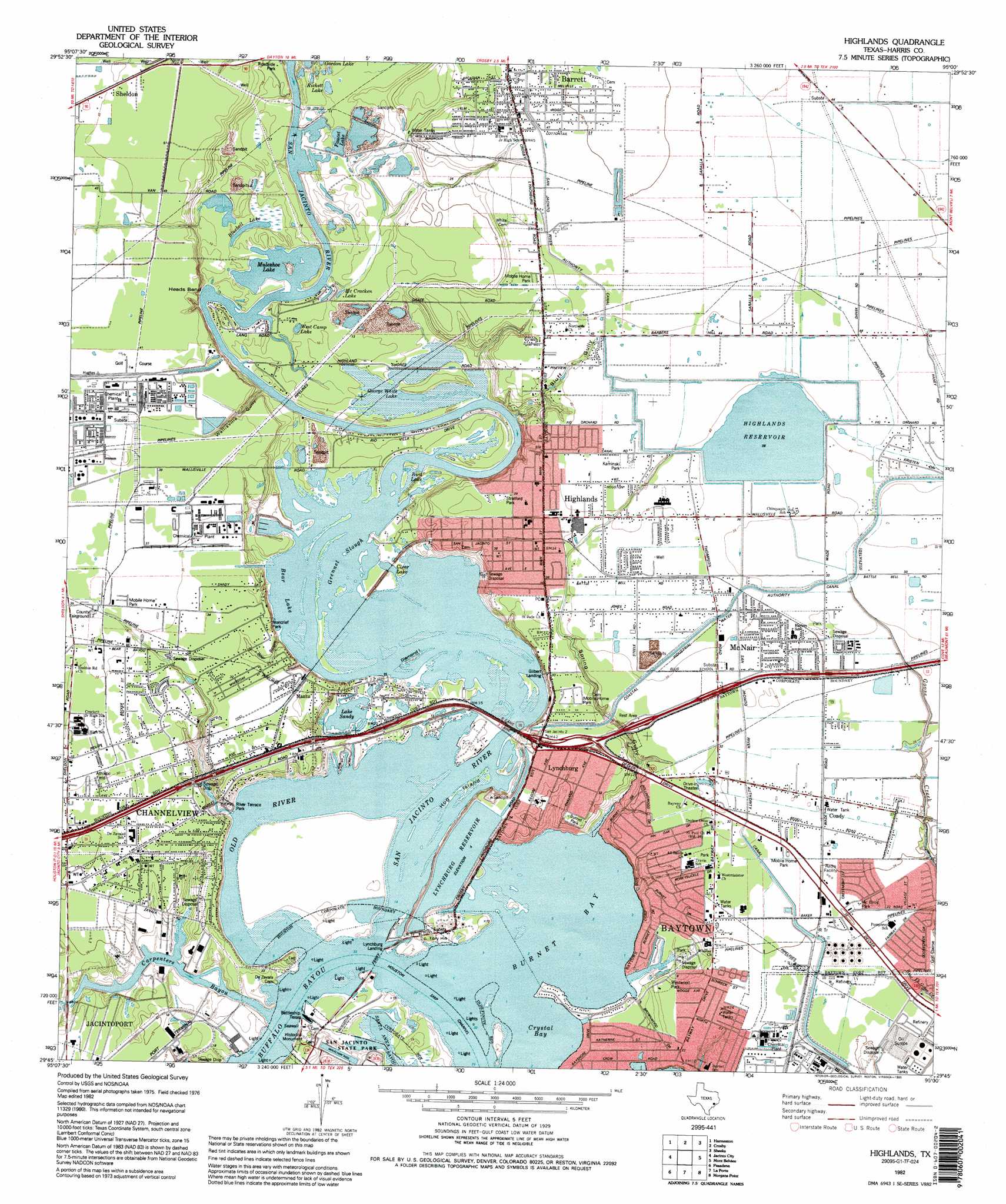
Highlands Topo Map Texas
To zoom in, hover over the map of Highlands
USGS Topo Quad 29095g1 - 1:24,000 scale
| Topo Map Name: | Highlands |
| USGS Topo Quad ID: | 29095g1 |
| Print Size: | ca. 21 1/4" wide x 27" high |
| Southeast Coordinates: | 29.75° N latitude / 95° W longitude |
| Map Center Coordinates: | 29.8125° N latitude / 95.0625° W longitude |
| U.S. State: | TX |
| Filename: | o29095g1.jpg |
| Download Map JPG Image: | Highlands topo map 1:24,000 scale |
| Map Type: | Topographic |
| Topo Series: | 7.5´ |
| Map Scale: | 1:24,000 |
| Source of Map Images: | United States Geological Survey (USGS) |
| Alternate Map Versions: |
Burnett Bay TX 1916 Download PDF Buy paper map Highlands TX 1955, updated 1956 Download PDF Buy paper map Highlands TX 1967, updated 1969 Download PDF Buy paper map Highlands TX 1982, updated 1983 Download PDF Buy paper map Highlands TX 1982, updated 1995 Download PDF Buy paper map Highlands TX 1995, updated 1998 Download PDF Buy paper map Highlands TX 2010 Download PDF Buy paper map Highlands TX 2013 Download PDF Buy paper map Highlands TX 2016 Download PDF Buy paper map |
1:24,000 Topo Quads surrounding Highlands
Maedan |
Moonshine Hill |
Huffman |
Dayton |
Liberty |
Humble |
Harmaston |
Crosby |
Sheeks |
Moss Bluff |
Settegast |
Jacinto City |
Highlands |
Mont Belvieu |
Cove |
Park Place |
Pasadena |
La Porte |
Morgan Point |
Umbrella Point |
Pearland |
Friendswood |
League City |
Bacliff |
Smith Point |
> Back to 29095e1 at 1:100,000 scale
> Back to 29094a1 at 1:250,000 scale
> Back to U.S. Topo Maps home
Highlands topo map: Gazetteer
Highlands: Airports
Jacintoport Heliport elevation 8m 26′LPC Heliport elevation 13m 42′
Red Barn Heliport elevation 9m 29′
Highlands: Bays
Burnet Bay elevation 1m 3′Crystal Bay elevation 2m 6′
Highlands: Bends
Heads Bend elevation 1m 3′Highlands: Channels
Old River elevation 1m 3′Highlands: Crossings
Interchange 783 elevation 10m 32′Interchange 784 elevation 7m 22′
Interchange 785 elevation 6m 19′
Interchange 786 elevation 5m 16′
Interchange 787 elevation 7m 22′
Interchange 788 elevation 11m 36′
Interchange 789 elevation 10m 32′
Interchange 790 elevation 8m 26′
Highlands: Dams
Highlands Reservoir Dam elevation 11m 36′Lynchburg Reservoir Dam elevation 5m 16′
Highlands: Guts
Grennel Slough elevation 1m 3′Highlands: Islands
Diamond Island elevation 1m 3′Hog Island elevation 1m 3′
Highlands: Lakes
Bear Lake elevation 1m 3′Bird Lake elevation 2m 6′
Bluebell Lake elevation 1m 3′
Clear Lake elevation 2m 6′
Faucet Lake elevation 3m 9′
George White Lake elevation 1m 3′
Gordon Lake elevation 4m 13′
Lake Sandy elevation 2m 6′
Lost Lake elevation 1m 3′
McCracken Lake elevation 2m 6′
Muleshoe Lake elevation 2m 6′
Rickett Lake elevation 3m 9′
West Camp Lake elevation 2m 6′
Whites Lake elevation 1m 3′
Highlands: Parks
Battleground Speedway elevation 8m 26′Battleship Texas elevation 2m 6′
Burnett Park elevation 10m 32′
Channelview Stadium elevation 10m 32′
Kaminski Park elevation 13m 42′
McElroy Park elevation 7m 22′
Meadowbrook Park elevation 2m 6′
Monterief Park elevation 9m 29′
River Terrace Park elevation 9m 29′
Stratford Park elevation 11m 36′
U S S Texas Battleship elevation 2m 6′
Westwood Park elevation 7m 22′
Highlands: Populated Places
Channelview elevation 9m 29′Coady elevation 9m 29′
Decker Terrace elevation 8m 26′
Four Corners elevation 10m 32′
Gilbert Landing elevation 10m 32′
Highlands elevation 11m 36′
Lake View Homes elevation 8m 26′
Lakeside Park Estates elevation 8m 26′
Lynchburg elevation 10m 32′
Lynchburg Landing elevation 2m 6′
Mantu elevation 11m 36′
McNair elevation 9m 29′
New Washington (historical) elevation 3m 9′
Wooster elevation 8m 26′
Highlands: Reservoirs
Highlands Reservoir elevation 12m 39′Lynchburg Reservoir elevation 5m 16′
Highlands: Streams
Buffalo Bayou elevation 1m 3′Carpenters Bayou elevation 2m 6′
Highlands: Valleys
Bluff Gully elevation 2m 6′Highlands digital topo map on disk
Buy this Highlands topo map showing relief, roads, GPS coordinates and other geographical features, as a high-resolution digital map file on DVD: