Houston Heights Topo Map Texas
To zoom in, hover over the map of Houston Heights
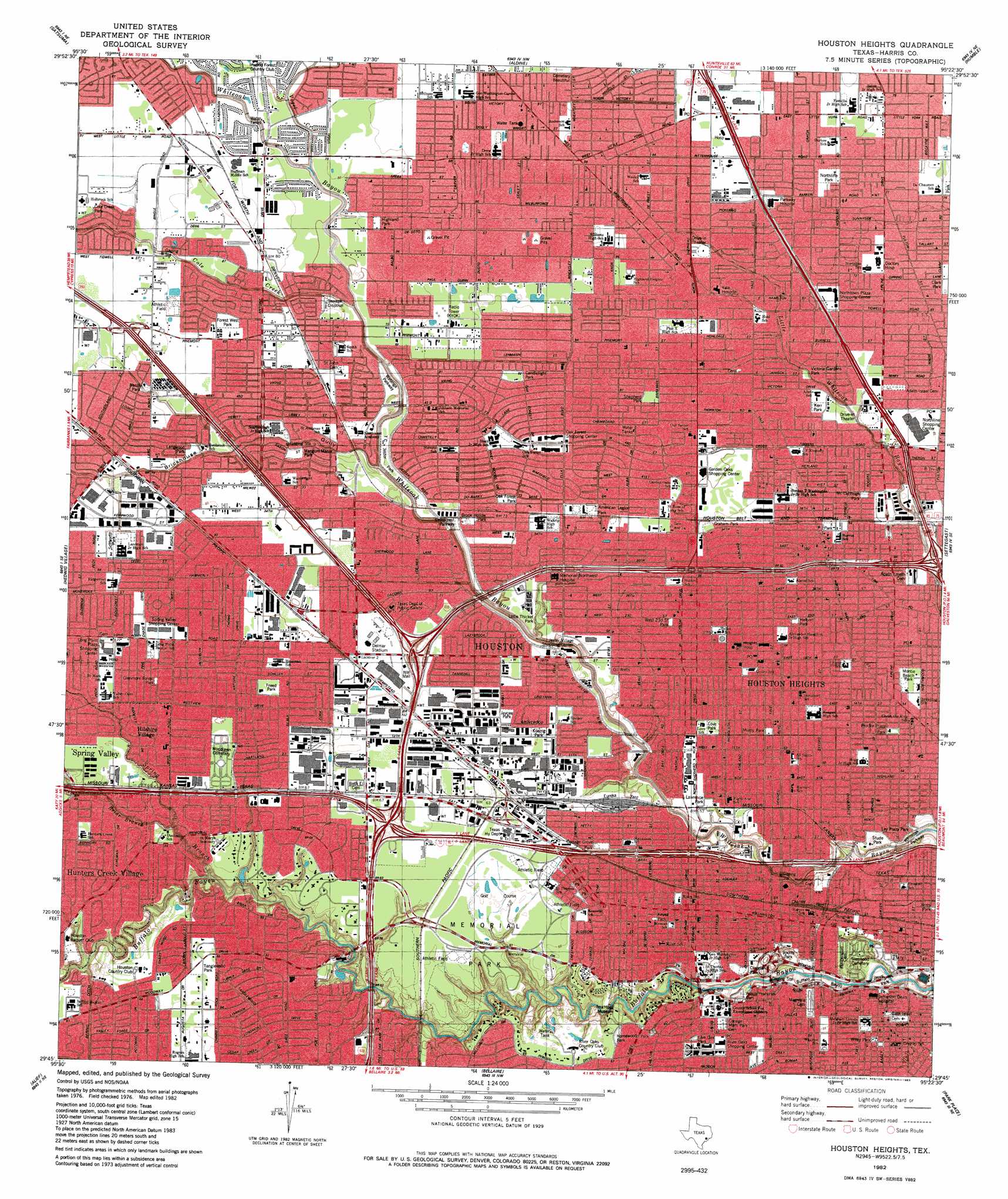
USGS Topo Quad 29095g4 - 1:24,000 scale
| Topo Map Name: | Houston Heights |
| USGS Topo Quad ID: | 29095g4 |
| Print Size: | ca. 21 1/4" wide x 27" high |
| Southeast Coordinates: | 29.75° N latitude / 95.375° W longitude |
| Map Center Coordinates: | 29.8125° N latitude / 95.4375° W longitude |
| U.S. State: | TX |
| Filename: | o29095g4.jpg |
| Download Map JPG Image: | Houston Heights topo map 1:24,000 scale |
| Map Type: | Topographic |
| Topo Series: | 7.5´ |
| Map Scale: | 1:24,000 |
| Source of Map Images: | United States Geological Survey (USGS) |
| Alternate Map Versions: |
Houston Heights TX 1915 Download PDF Buy paper map Houston Heights TX 1915 Download PDF Buy paper map Houston Heights TX 1955, updated 1957 Download PDF Buy paper map Houston Heights TX 1967, updated 1970 Download PDF Buy paper map Houston Heights TX 1982, updated 1983 Download PDF Buy paper map Houston Heights TX 1995, updated 1998 Download PDF Buy paper map Houston Heights TX 2010 Download PDF Buy paper map Houston Heights TX 2013 Download PDF Buy paper map Houston Heights TX 2016 Download PDF Buy paper map |
1:24,000 Topo Quads surrounding Houston Heights
Rose Hill |
Tomball |
Spring |
Maedan |
Moonshine Hill |
Cypress |
Satsuma |
Aldine |
Humble |
Harmaston |
Addicks |
Hedwig Village |
Houston Heights |
Settegast |
Jacinto City |
Clodine |
Alief |
Bellaire |
Park Place |
Pasadena |
Sugar Land |
Missouri City |
Almeda |
Pearland |
Friendswood |
> Back to 29095e1 at 1:100,000 scale
> Back to 29094a1 at 1:250,000 scale
> Back to U.S. Topo Maps home
Houston Heights topo map: Gazetteer
Houston Heights: Airports
Delta Mechanical Incorporated Heliport elevation 23m 75′KHOU-TV Heliport elevation 14m 45′
Parkview Center Hospital Heliport elevation 28m 91′
Porta-Kamp 12th Street Heliport elevation 21m 68′
Star Houston Heliport elevation 20m 65′
Tex-Star Heliport elevation 18m 59′
The America Tower Heliport elevation 14m 45′
Houston Heights: Crossings
Interchange 10 elevation 19m 62′Interchange 11A elevation 25m 82′
Interchange 11B elevation 20m 65′
Interchange 12 elevation 29m 95′
Interchange 13 elevation 21m 68′
Interchange 13C elevation 19m 62′
Interchange 14 elevation 19m 62′
Interchange 15 elevation 20m 65′
Interchange 16B elevation 20m 65′
Interchange 17B elevation 18m 59′
Interchange 52A elevation 18m 59′
Interchange 52B elevation 21m 68′
Interchange 53 elevation 22m 72′
Interchange 54 elevation 22m 72′
Interchange 55A elevation 27m 88′
Interchange 55B elevation 29m 95′
Interchange 760 elevation 20m 65′
Interchange 761A elevation 21m 68′
Interchange 761B elevation 21m 68′
Interchange 764 elevation 14m 45′
Interchange 765A elevation 10m 32′
Interchange 765B elevation 11m 36′
Interchange 766 elevation 16m 52′
Interchange 767B elevation 12m 39′
Interchange 9B elevation 15m 49′
Houston Heights: Parks
American Legion Park elevation 23m 75′Brook Hollow Park elevation 20m 65′
Candlelight Park elevation 25m 82′
Carver Park elevation 27m 88′
Cleveland Park elevation 14m 45′
Cole Creek Park elevation 26m 85′
Cooper Park elevation 23m 75′
Cottage Grove Park elevation 17m 55′
Delmar Stadium elevation 22m 72′
Dyer Stadium elevation 22m 72′
Evers Park elevation 21m 68′
Forest West Park elevation 26m 85′
Freed Park elevation 22m 72′
Glenmore Forest Park elevation 23m 75′
Graham Park elevation 21m 68′
Granger Stadium elevation 15m 49′
Halbert Park elevation 20m 65′
Helberg Park elevation 17m 55′
Helberg Park elevation 20m 65′
Highland Park elevation 25m 82′
Homewood Park elevation 18m 59′
Independence Park elevation 18m 59′
Jaycee Park elevation 20m 65′
Kerr Park elevation 20m 65′
Langwood Park elevation 23m 75′
Lawrence Park elevation 17m 55′
Live Oak Park elevation 17m 55′
Love Park elevation 20m 65′
Malibu Park elevation 24m 78′
Mangum Manor Park elevation 22m 72′
Memorial Park elevation 18m 59′
Milroy Park elevation 18m 59′
Monte Beach Park elevation 16m 52′
Montie Beach Park elevation 16m 52′
Northline Park elevation 25m 82′
Oak Forest Park elevation 23m 75′
Oak Forest Parkway elevation 20m 65′
Panther Stadium elevation 24m 78′
Rosslyn Park elevation 26m 85′
Sabine Park elevation 18m 59′
Saint Thomas High School Baseball Field elevation 16m 52′
Scarborough High School Baseball Field elevation 21m 68′
Schwartz Park elevation 25m 82′
Spotts Park elevation 17m 55′
Stude Park elevation 12m 39′
T C Jester Park elevation 19m 62′
Tanglewood Park elevation 20m 65′
Waltrip High School Baseball Field elevation 23m 75′
Watongo Parkway Park elevation 20m 65′
White Oak Park elevation 14m 45′
Houston Heights: Populated Places
Antoine Forest Estates elevation 24m 78′Arbor Oaks elevation 25m 82′
Bayou Bend elevation 25m 82′
Brook Smith elevation 15m 49′
Brookhollow elevation 22m 72′
Candlelight elevation 22m 72′
Candlelight Forest West elevation 26m 85′
Candlelight Oaks Village elevation 24m 78′
Central Park Northwest elevation 22m 72′
Chateau Forest elevation 26m 85′
Eureka Acres elevation 22m 72′
Fairway Park elevation 22m 72′
Forest Pine elevation 25m 82′
Forest West Shopping Center elevation 26m 85′
Garden Oaks elevation 24m 78′
Glenburnie elevation 20m 65′
Graceland Terrace elevation 21m 68′
Highland Acres Homes elevation 27m 88′
Highland Heights elevation 27m 88′
Hilshire Village elevation 21m 68′
Holly Park elevation 21m 68′
Houston Heights elevation 18m 59′
Hunters Creek Village elevation 20m 65′
Inwood Pines elevation 26m 85′
Magnum Manor elevation 23m 75′
Melrose Gardens elevation 25m 82′
Monarch Oaks elevation 23m 75′
Oak Forest elevation 20m 65′
Oaks of Inwood elevation 25m 82′
Pine Terrace elevation 22m 72′
Pinemont Plaza elevation 24m 78′
Ridgecrest elevation 25m 82′
Rosslyn elevation 25m 82′
Shady Acres elevation 16m 52′
Sheraton Oaks elevation 24m 78′
Spring Oaks elevation 23m 75′
Springdale elevation 25m 82′
Stone Heights elevation 19m 62′
Stude elevation 18m 59′
Timber Grove Manor elevation 20m 65′
Westview Terrace elevation 21m 68′
Woodland Heights elevation 15m 49′
Houston Heights: Post Offices
Houston Heights Post Office elevation 19m 62′Spring Valley Post Office elevation 23m 75′
Houston Heights: Reservoirs
Houston Heights Waterworks Reservoir elevation 20m 65′Houston Heights: Springs
Beauchamps Springs elevation 16m 52′Houston Heights: Streams
Briar Branch elevation 8m 26′Cole Creek elevation 15m 49′
Spring Branch elevation 11m 36′
Vogel Creek elevation 17m 55′
Houston Heights: Trails
B T Washington High School SPARK Park Trail elevation 20m 65′Briargrove Elementary SPARK Park Trail elevation 20m 65′
Browning Elementary SPARK Park Trail elevation 16m 52′
Cleveland Park Trail elevation 14m 45′
Crockett Elementary SPARK Park Trail elevation 17m 55′
De Chaumes Elementary SPARK Park Trail elevation 23m 75′
Durkee Elementary SPARK Park Trail elevation 25m 82′
Field Elementary SPARK Park Trail elevation 18m 59′
Garden Oaks Elementary SPARK Park Trail elevation 23m 75′
Gregory - Lincoln Education Center SPARK Park Trail elevation 17m 55′
Harvard Elementary SPARK Park Trail elevation 18m 59′
Helms Elementary SPARK Park Trail elevation 20m 65′
Highland Heights Elementary SPARK Park Trail elevation 26m 85′
Hohl Elementary SPARK Park Trail elevation 23m 75′
Holden Elementary SPARK Park Trail elevation 21m 68′
Houston Arboretum and Nature Center Trail elevation 18m 59′
K Smith Elementary SPARK Park Trail elevation 24m 78′
Kennedy Elementary SPARK Park Trail elevation 21m 68′
Langwood Park Trail elevation 23m 75′
Mangum Manor Park Trail elevation 22m 72′
Memorial Elementary SPARK Park Trail elevation 18m 59′
Memorial Park Jogging Trail elevation 18m 59′
Northline Elementary SPARK Park Trail elevation 22m 72′
Oak Forest Elementary SPARK Park Trail elevation 24m 78′
Reagan High School SPARK Park Trail elevation 18m 59′
Rogers Elementary SPARK Park Trail elevation 20m 65′
Sinclair Elementary SPARK Park Trail elevation 18m 59′
Stevenson Elementary SPARK Park Trail elevation 17m 55′
Wainwright Elementary SPARK Park Trail elevation 23m 75′
Wharton Elementary SPARK Park Trail elevation 17m 55′
Houston Heights: Valleys
Brickhouse Gully elevation 15m 49′Houston Heights digital topo map on disk
Buy this Houston Heights topo map showing relief, roads, GPS coordinates and other geographical features, as a high-resolution digital map file on DVD: