Katy Topo Map Texas
To zoom in, hover over the map of Katy
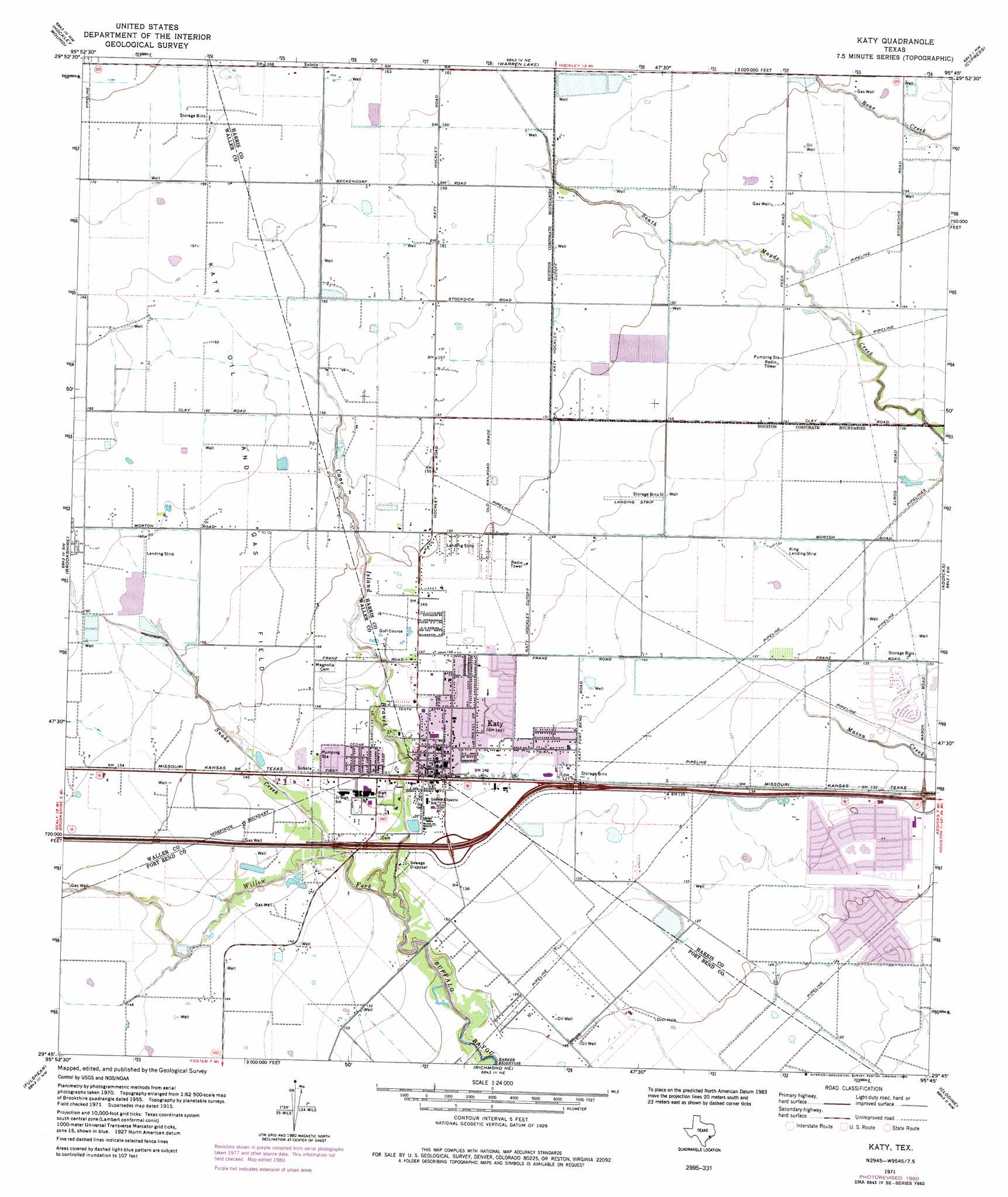
USGS Topo Quad 29095g7 - 1:24,000 scale
| Topo Map Name: | Katy |
| USGS Topo Quad ID: | 29095g7 |
| Print Size: | ca. 21 1/4" wide x 27" high |
| Southeast Coordinates: | 29.75° N latitude / 95.75° W longitude |
| Map Center Coordinates: | 29.8125° N latitude / 95.8125° W longitude |
| U.S. State: | TX |
| Filename: | o29095g7.jpg |
| Download Map JPG Image: | Katy topo map 1:24,000 scale |
| Map Type: | Topographic |
| Topo Series: | 7.5´ |
| Map Scale: | 1:24,000 |
| Source of Map Images: | United States Geological Survey (USGS) |
| Alternate Map Versions: |
Katy TX 1915 Download PDF Buy paper map Katy TX 1915 Download PDF Buy paper map Katy TX 1915, updated 1961 Download PDF Buy paper map Katy TX 1971, updated 1974 Download PDF Buy paper map Katy TX 1971, updated 1980 Download PDF Buy paper map Katy TX 1971, updated 1980 Download PDF Buy paper map Katy TX 2010 Download PDF Buy paper map Katy TX 2013 Download PDF Buy paper map Katy TX 2016 Download PDF Buy paper map |
1:24,000 Topo Quads surrounding Katy
Hempstead |
Waller |
Hockley |
Rose Hill |
Tomball |
Sunny Side |
Hockley Mound |
Warren Lake |
Cypress |
Satsuma |
San Felipe |
Brookshire |
Katy |
Addicks |
Hedwig Village |
Wallis |
Fulshear |
Richmond Ne |
Clodine |
Alief |
East Bernard |
Orchard |
Richmond |
Sugar Land |
Missouri City |
> Back to 29095e1 at 1:100,000 scale
> Back to 29094a1 at 1:250,000 scale
> Back to U.S. Topo Maps home
Katy topo map: Gazetteer
Katy: Airports
Darmar Medical Emergency Heliport elevation 42m 137′Freeman Property Airport elevation 45m 147′
Hoffpauir Airport elevation 40m 131′
Horn-Katy Hawk International Airport elevation 41m 134′
King Air Airport elevation 42m 137′
Katy: Crossings
Interchange 743 elevation 41m 134′Interchange 745 elevation 40m 131′
Katy: Dams
Tucker Lake Dam elevation 39m 127′Katy: Parks
Jack Rhodes Memorial Stadium elevation 43m 141′Katy City Park elevation 45m 147′
Katy High School Baseball Field elevation 42m 137′
Katy High School Football Stadium elevation 42m 137′
Katy Park elevation 44m 144′
Katy: Populated Places
Cimarron elevation 38m 124′Cimmaron South elevation 37m 121′
Falcon Point elevation 40m 131′
Fawn Lake elevation 43m 141′
Governor Place elevation 40m 131′
Heritage Meadows elevation 43m 141′
Katy elevation 43m 141′
Katy Estates elevation 44m 144′
Katyland elevation 44m 144′
Phillipe elevation 45m 147′
Pin Oak Village elevation 40m 131′
Pine Forest elevation 45m 147′
Pineview Terrace elevation 45m 147′
Whispering Lakes elevation 44m 144′
Williams Chase elevation 41m 134′
Williamsburg Colony elevation 41m 134′
Williamsburg Hamlet elevation 41m 134′
Williamsburg Parish elevation 42m 137′
Williamsburg Parish II elevation 42m 137′
Williamsburg Settlement elevation 40m 131′
Katy: Reservoirs
Tucker Lake elevation 39m 127′Katy: Streams
Cane Island Branch elevation 36m 118′Snake Creek elevation 39m 127′
Willow Fork elevation 36m 118′
Katy digital topo map on disk
Buy this Katy topo map showing relief, roads, GPS coordinates and other geographical features, as a high-resolution digital map file on DVD: