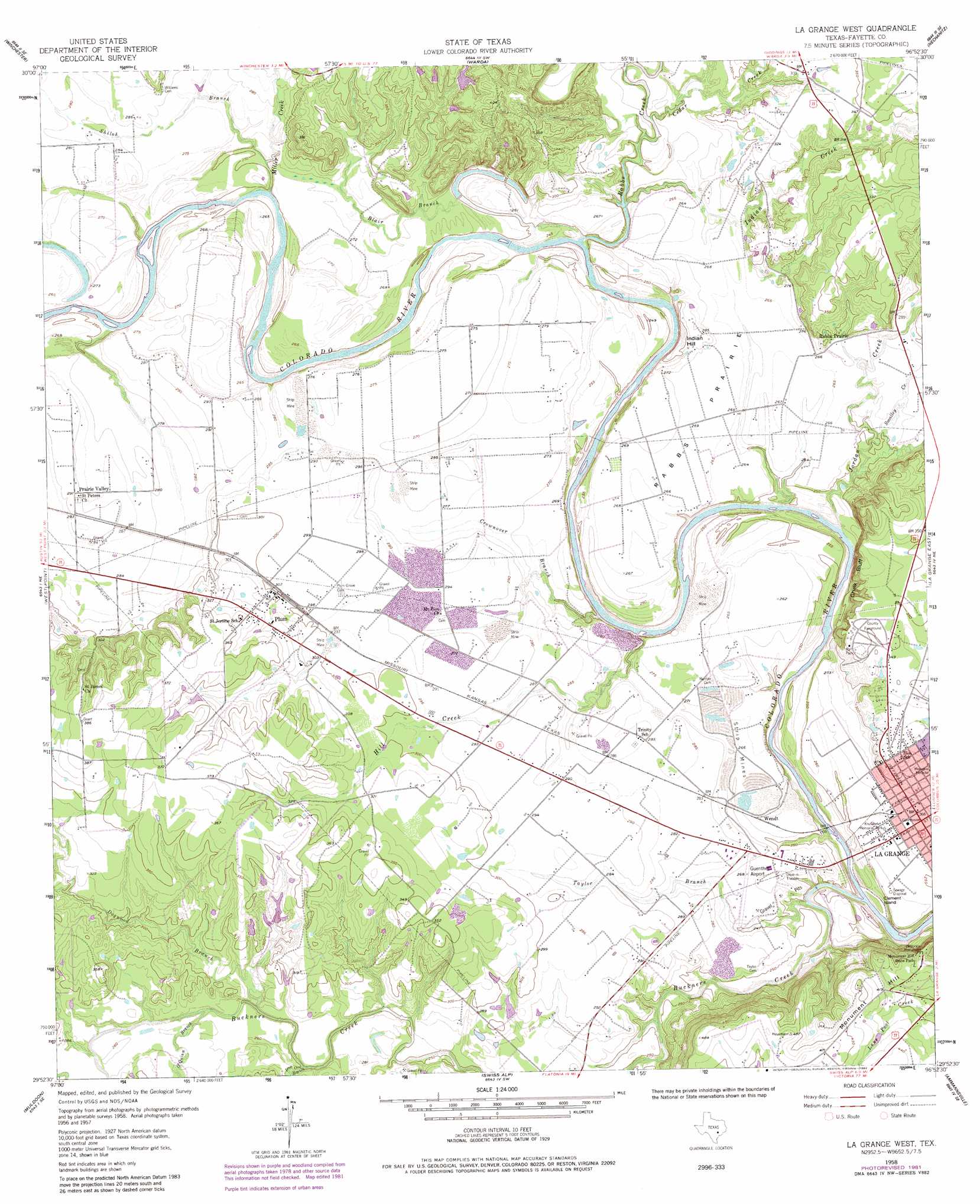
La Grange West Topo Map Texas
To zoom in, hover over the map of La Grange West
USGS Topo Quad 29096h8 - 1:24,000 scale
| Topo Map Name: | La Grange West |
| USGS Topo Quad ID: | 29096h8 |
| Print Size: | ca. 21 1/4" wide x 27" high |
| Southeast Coordinates: | 29.875° N latitude / 96.875° W longitude |
| Map Center Coordinates: | 29.9375° N latitude / 96.9375° W longitude |
| U.S. State: | TX |
| Filename: | o29096h8.jpg |
| Download Map JPG Image: | La Grange West topo map 1:24,000 scale |
| Map Type: | Topographic |
| Topo Series: | 7.5´ |
| Map Scale: | 1:24,000 |
| Source of Map Images: | United States Geological Survey (USGS) |
| Alternate Map Versions: |
La Grange West TX 1958, updated 1958 Download PDF Buy paper map La Grange West TX 1958, updated 1974 Download PDF Buy paper map La Grange West TX 1958, updated 1982 Download PDF Buy paper map La Grange West TX 2010 Download PDF Buy paper map La Grange West TX 2013 Download PDF Buy paper map La Grange West TX 2016 Download PDF Buy paper map |
1:24,000 Topo Quads surrounding La Grange West
Smithville Nw |
Paige |
Giddings |
Ledbetter |
Carmine |
Smithville |
Winchester |
Warda |
Nechanitz |
Round Top |
Togo |
West Point |
La Grange West |
La Grange East |
Fayetteville |
Cistern |
Muldoon |
Swiss Alp |
Ammannsville |
Ellinger |
Flatonia Nw |
Flatonia |
Schulenburg |
Weimar |
Borden |
> Back to 29096e1 at 1:100,000 scale
> Back to 29096a1 at 1:250,000 scale
> Back to U.S. Topo Maps home
La Grange West topo map: Gazetteer
La Grange West: Airports
Fayette Regional Air Center elevation 96m 314′Guenther Field/La Grange Municipal Airport elevation 81m 265′
La Grange West: Bridges
State Highway 71 Bridge elevation 79m 259′La Grange West: Cliffs
Chalk Bluff elevation 83m 272′La Grange West: Dams
Clear Lake Pines Dam 1 elevation 107m 351′Clear Lake Pines Dam 3 elevation 103m 337′
Clear Lake Pines Dam 4 elevation 103m 337′
La Grange West: Flats
Rabbs Prairie elevation 82m 269′La Grange West: Islands
Clement Island elevation 69m 226′La Grange West: Parks
Jaycee Park elevation 73m 239′Kruschel Memorial Park elevation 79m 259′
Kruschel Park elevation 79m 259′
Monument Hill State Park elevation 136m 446′
La Grange West: Populated Places
La Grange elevation 81m 265′Plum elevation 91m 298′
Prairie Valley elevation 89m 291′
Rabbs Prairie elevation 81m 265′
Wendt elevation 82m 269′
La Grange West: Reservoirs
Clear Lake Pines 1 elevation 107m 351′Clear Lake Pines 3 elevation 103m 337′
Clear Lake Pines 4 elevation 103m 337′
La Grange West: Springs
Mount Maria Spring elevation 77m 252′La Grange West: Streams
Blair Branch elevation 70m 229′Buckners Creek elevation 65m 213′
Cedar Creek elevation 74m 242′
Crownover Branch elevation 68m 223′
Dogwood Branch elevation 82m 269′
Hill Creek elevation 68m 223′
Indian Creek elevation 72m 236′
Iron Ore Branch elevation 80m 262′
Jordan Creek elevation 67m 219′
Miller Creek elevation 75m 246′
O'Quinn Branch elevation 82m 269′
Rabbs Creek elevation 70m 229′
Shiloh Branch elevation 78m 255′
Smalley Creek elevation 73m 239′
Taylor Branch elevation 64m 209′
La Grange West: Summits
Indian Hill elevation 101m 331′Monument Hill elevation 138m 452′
La Grange West: Trails
Monument Hill and Kreische Brewery - Brewery Trail elevation 129m 423′Monument Hill and Kreische Brewery History Trail elevation 132m 433′
Monument Hill and Kreische Brewery Nature Trail elevation 132m 433′
La Grange West digital topo map on disk
Buy this La Grange West topo map showing relief, roads, GPS coordinates and other geographical features, as a high-resolution digital map file on DVD: