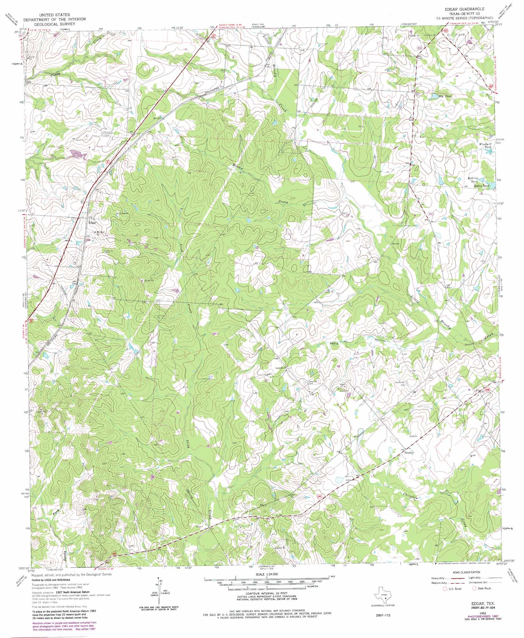
Edgar Topo Map Texas
To zoom in, hover over the map of Edgar
USGS Topo Quad 29097b2 - 1:24,000 scale
| Topo Map Name: | Edgar |
| USGS Topo Quad ID: | 29097b2 |
| Print Size: | ca. 21 1/4" wide x 27" high |
| Southeast Coordinates: | 29.125° N latitude / 97.125° W longitude |
| Map Center Coordinates: | 29.1875° N latitude / 97.1875° W longitude |
| U.S. State: | TX |
| Filename: | o29097b2.jpg |
| Download Map JPG Image: | Edgar topo map 1:24,000 scale |
| Map Type: | Topographic |
| Topo Series: | 7.5´ |
| Map Scale: | 1:24,000 |
| Source of Map Images: | United States Geological Survey (USGS) |
| Alternate Map Versions: |
Edgar TX 1962, updated 1964 Download PDF Buy paper map Edgar TX 1962, updated 1983 Download PDF Buy paper map Edgar TX 1962, updated 1987 Download PDF Buy paper map Edgar TX 2010 Download PDF Buy paper map Edgar TX 2013 Download PDF Buy paper map Edgar TX 2016 Download PDF Buy paper map |
1:24,000 Topo Quads surrounding Edgar
Gonzales South |
Hamon |
Shiner |
Wied |
Hallettsville |
Cheapside |
Hochheim |
Yoakum |
Sweet Home |
Ezzell |
Westhoff |
Concrete |
Edgar |
Terryville |
Hope |
Blackwell Lake |
Cuero |
Verhelle |
Fordtran |
Peck Branch |
Yorktown East |
Meyersville |
Mission Valley |
Nursery |
Inez Nw |
> Back to 29097a1 at 1:100,000 scale
> Back to 29096a1 at 1:250,000 scale
> Back to U.S. Topo Maps home
Edgar topo map: Gazetteer
Edgar: Dams
Flying F Ranch Lake Dam elevation 81m 265′Morrow Dam elevation 81m 265′
Edgar: Populated Places
Edgar elevation 99m 324′Stratton elevation 87m 285′
Edgar: Reservoirs
Bathing Tank elevation 82m 269′Big Tank elevation 85m 278′
Flying F Ranch Lake elevation 81m 265′
Kelly Tank elevation 80m 262′
Morrow Lake elevation 81m 265′
Windmill Tank elevation 79m 259′
Edgar: Streams
Willow Prong elevation 72m 236′Edgar: Valleys
Petty Hollow elevation 65m 213′Edgar digital topo map on disk
Buy this Edgar topo map showing relief, roads, GPS coordinates and other geographical features, as a high-resolution digital map file on DVD: