Darst Creek Topo Map Texas
To zoom in, hover over the map of Darst Creek
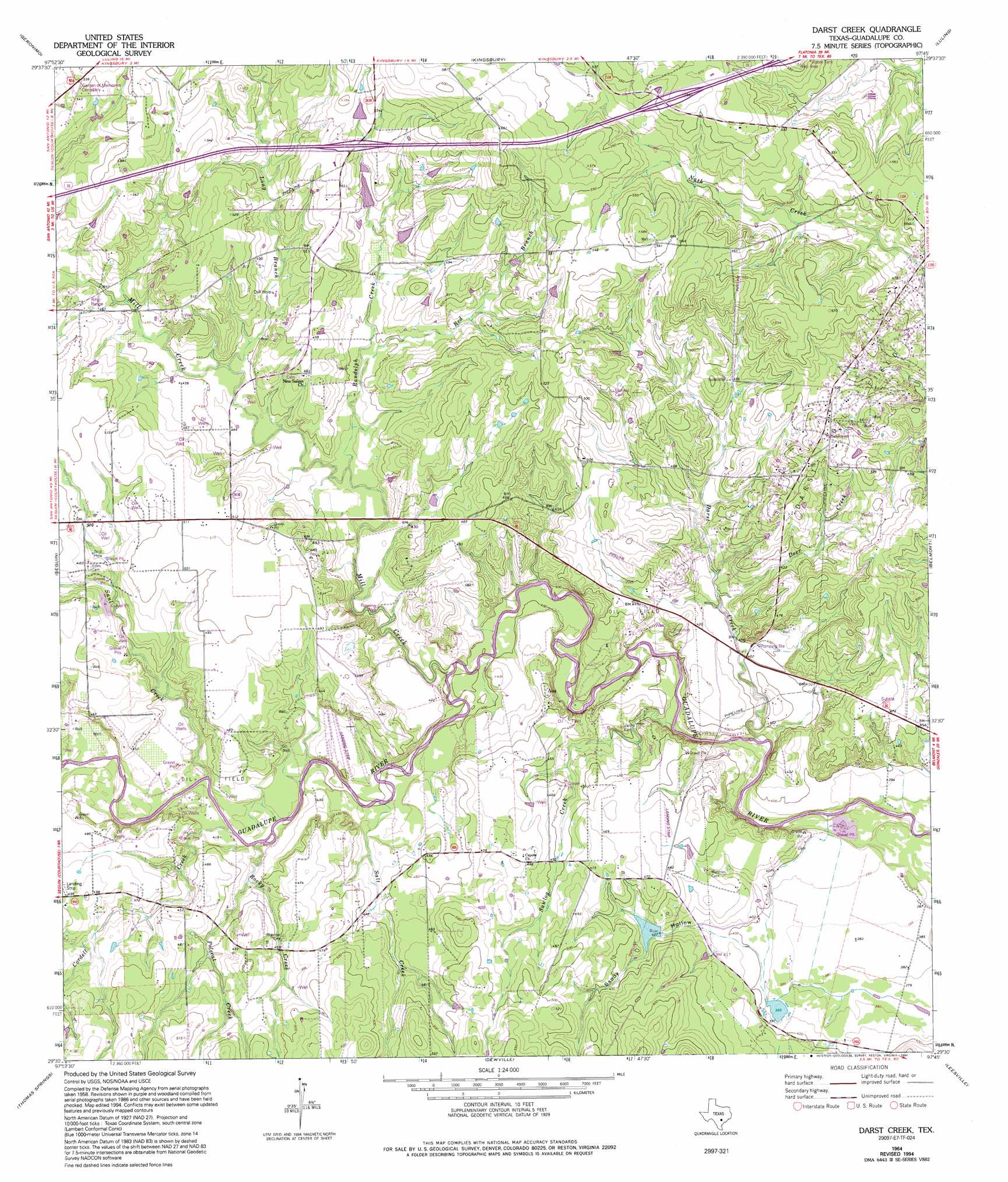
USGS Topo Quad 29097e7 - 1:24,000 scale
| Topo Map Name: | Darst Creek |
| USGS Topo Quad ID: | 29097e7 |
| Print Size: | ca. 21 1/4" wide x 27" high |
| Southeast Coordinates: | 29.5° N latitude / 97.75° W longitude |
| Map Center Coordinates: | 29.5625° N latitude / 97.8125° W longitude |
| U.S. State: | TX |
| Filename: | o29097e7.jpg |
| Download Map JPG Image: | Darst Creek topo map 1:24,000 scale |
| Map Type: | Topographic |
| Topo Series: | 7.5´ |
| Map Scale: | 1:24,000 |
| Source of Map Images: | United States Geological Survey (USGS) |
| Alternate Map Versions: |
Darst Creek TX 1964, updated 1965 Download PDF Buy paper map Darst Creek TX 1964, updated 1975 Download PDF Buy paper map Darst Creek TX 1964, updated 1994 Download PDF Buy paper map Darst Creek TX 2010 Download PDF Buy paper map Darst Creek TX 2013 Download PDF Buy paper map Darst Creek TX 2016 Download PDF Buy paper map |
1:24,000 Topo Quads surrounding Darst Creek
Hunter |
San Marcos South |
Martindale |
Lockhart South |
Mcmahan |
New Braunfels East |
Geronimo |
Kingsbury |
Luling |
Harwood |
Mcqueeney |
Seguin |
Darst Creek |
Belmont |
Ottine |
New Berlin |
Thomas Springs |
Dewville |
Leesville |
Cost |
La Vernia |
Alum |
Nixon |
Smiley |
Pilgrim |
> Back to 29097e1 at 1:100,000 scale
> Back to 29096a1 at 1:250,000 scale
> Back to U.S. Topo Maps home
Darst Creek topo map: Gazetteer
Darst Creek: Airports
Glen Beicker Ranch Airport elevation 141m 462′Lackorn Airport elevation 133m 436′
Darst Creek: Dams
Bishop Lake Dam elevation 119m 390′Holmes Lake Dam elevation 128m 419′
Darst Creek: Oilfields
Darst Oil Field elevation 146m 479′Darst Creek: Reservoirs
Bishop Lake elevation 119m 390′Holmes Lake elevation 128m 419′
Darst Creek: Streams
Cordell Creek elevation 123m 403′Darst Creek elevation 112m 367′
Deer Creek elevation 120m 393′
Long Branch elevation 134m 439′
Mill Creek elevation 117m 383′
Polecat Creek elevation 128m 419′
Randolph Creek elevation 128m 419′
Red Branch elevation 133m 436′
Rocky Creek elevation 123m 403′
Salt Creek elevation 122m 400′
Saul Creek elevation 124m 406′
Sawlog Creek elevation 110m 360′
Darst Creek: Valleys
Sandy Hollow elevation 121m 396′Darst Creek digital topo map on disk
Buy this Darst Creek topo map showing relief, roads, GPS coordinates and other geographical features, as a high-resolution digital map file on DVD: