Red Rock Topo Map Texas
To zoom in, hover over the map of Red Rock
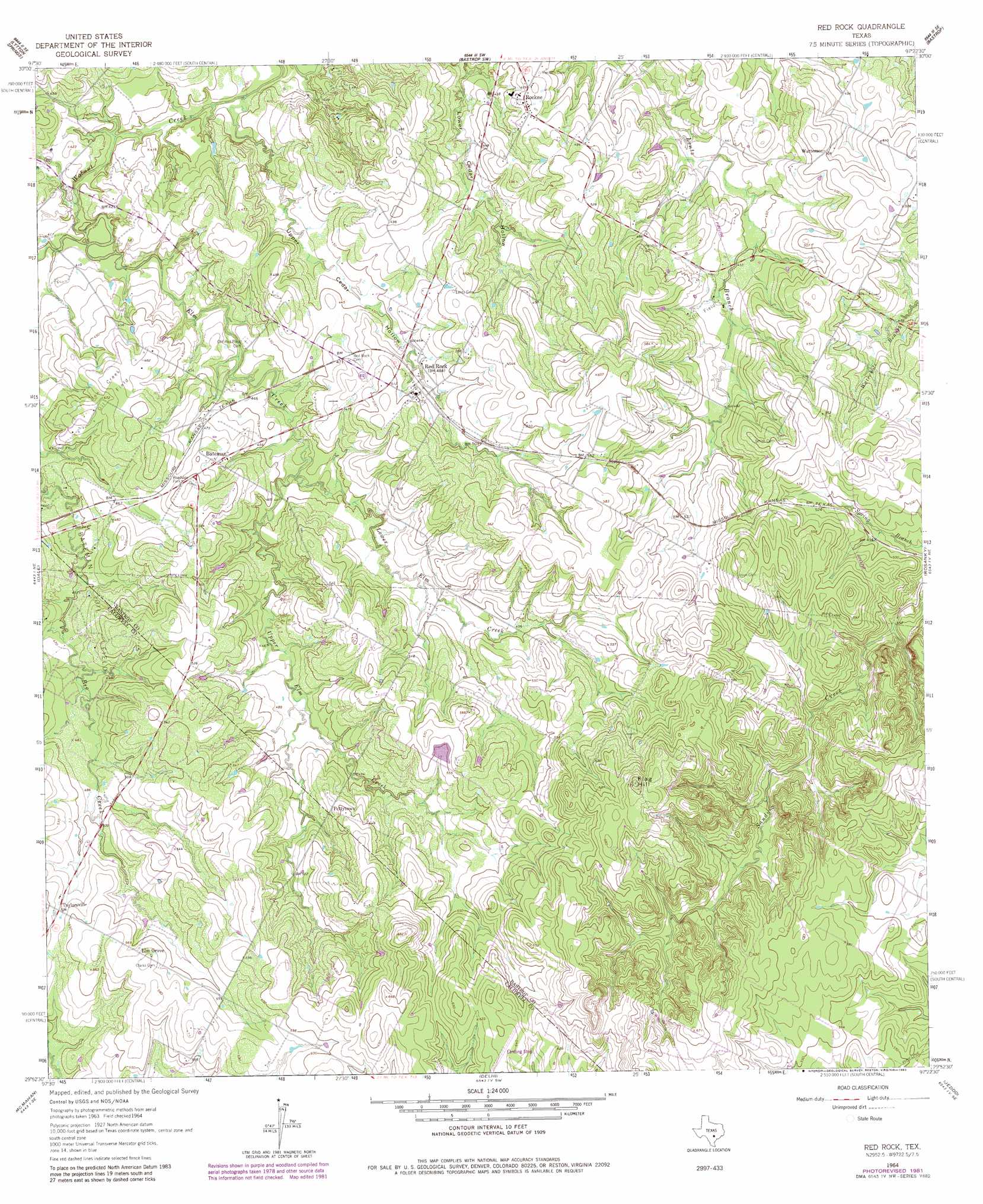
USGS Topo Quad 29097h4 - 1:24,000 scale
| Topo Map Name: | Red Rock |
| USGS Topo Quad ID: | 29097h4 |
| Print Size: | ca. 21 1/4" wide x 27" high |
| Southeast Coordinates: | 29.875° N latitude / 97.375° W longitude |
| Map Center Coordinates: | 29.9375° N latitude / 97.4375° W longitude |
| U.S. State: | TX |
| Filename: | o29097h4.jpg |
| Download Map JPG Image: | Red Rock topo map 1:24,000 scale |
| Map Type: | Topographic |
| Topo Series: | 7.5´ |
| Map Scale: | 1:24,000 |
| Source of Map Images: | United States Geological Survey (USGS) |
| Alternate Map Versions: |
Red Rock TX 1964, updated 1966 Download PDF Buy paper map Red Rock TX 1964, updated 1981 Download PDF Buy paper map Red Rock TX 2010 Download PDF Buy paper map Red Rock TX 2013 Download PDF Buy paper map Red Rock TX 2016 Download PDF Buy paper map |
1:24,000 Topo Quads surrounding Red Rock
Montopolis |
Webberville |
Utley |
Lake Bastrop |
Smithville Nw |
Creedmoor |
Lytton Springs |
Bastrop Sw |
Bastrap |
Smithville |
Lockhart North |
Dale |
Red Rock |
Rosanky |
Togo |
Lockhart South |
Mcmahan |
Delhi |
Jeddo |
Cistern |
Luling |
Harwood |
Sandy Fork |
Waelder |
Flatonia Nw |
> Back to 29097e1 at 1:100,000 scale
> Back to 29096a1 at 1:250,000 scale
> Back to U.S. Topo Maps home
Red Rock topo map: Gazetteer
Red Rock: Dams
Huber Lake Dam elevation 167m 547′Red Rock: Oilfields
Bateman Oil Field elevation 146m 479′Bee Creek Oil Field elevation 146m 479′
Carrol Lentz Oil Field elevation 132m 433′
Red Rock: Populated Places
Bateman elevation 148m 485′Elm Grove elevation 173m 567′
Pettytown elevation 164m 538′
Red Rock elevation 149m 488′
Rockne elevation 145m 475′
Taylorsville elevation 162m 531′
Watterson elevation 154m 505′
Red Rock: Reservoirs
Huber Lake elevation 167m 547′Red Rock: Streams
Elm Creek elevation 122m 400′Lower Elm Creek elevation 131m 429′
Upper Elm Creek elevation 131m 429′
Red Rock: Summits
Flag Hill elevation 221m 725′Red Rock: Valleys
Upper Cedar Hollow elevation 117m 383′Red Rock digital topo map on disk
Buy this Red Rock topo map showing relief, roads, GPS coordinates and other geographical features, as a high-resolution digital map file on DVD: