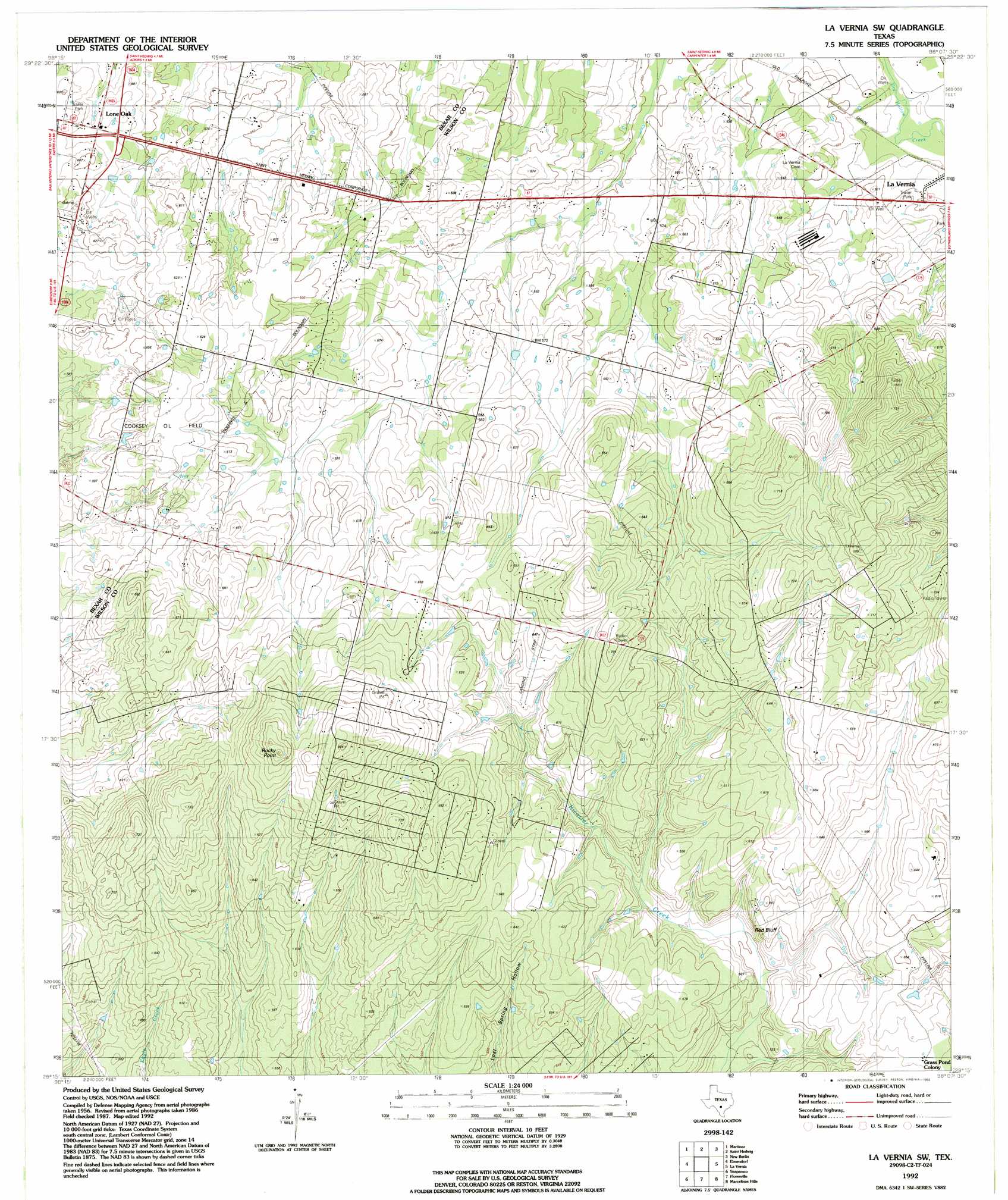
La Vernia Sw Topo Map Texas
To zoom in, hover over the map of La Vernia Sw
USGS Topo Quad 29098c2 - 1:24,000 scale
| Topo Map Name: | La Vernia Sw |
| USGS Topo Quad ID: | 29098c2 |
| Print Size: | ca. 21 1/4" wide x 27" high |
| Southeast Coordinates: | 29.25° N latitude / 98.125° W longitude |
| Map Center Coordinates: | 29.3125° N latitude / 98.1875° W longitude |
| U.S. State: | TX |
| Filename: | o29098c2.jpg |
| Download Map JPG Image: | La Vernia Sw topo map 1:24,000 scale |
| Map Type: | Topographic |
| Topo Series: | 7.5´ |
| Map Scale: | 1:24,000 |
| Source of Map Images: | United States Geological Survey (USGS) |
| Alternate Map Versions: |
La Vernia SW TX 1958, updated 1961 Download PDF Buy paper map La Vernia SW TX 1958, updated 1975 Download PDF Buy paper map La Vernia SW TX 1992, updated 1992 Download PDF Buy paper map La Vernia SW TX 2010 Download PDF Buy paper map La Vernia SW TX 2013 Download PDF Buy paper map La Vernia SW TX 2016 Download PDF Buy paper map |
1:24,000 Topo Quads surrounding La Vernia Sw
Longhorn |
Schertz |
Marion |
Mcqueeney |
Seguin |
San Antonio East |
Martinez |
Saint Hedwig |
New Berlin |
Thomas Springs |
Southton |
Elmendorf |
La Vernia Sw |
La Vernia |
Alum |
Losoya |
Saspamco |
Floresville |
Marcelinas Hills |
Stockdale |
Leming |
Saspamco Se |
Dewees |
Poth |
Kosciusko |
> Back to 29098a1 at 1:100,000 scale
> Back to 29098a1 at 1:250,000 scale
> Back to U.S. Topo Maps home
La Vernia Sw topo map: Gazetteer
La Vernia Sw: Airports
Cleveland Airport elevation 189m 620′McCreless Farm Airport elevation 162m 531′
La Vernia Sw: Cliffs
Red Bluff elevation 167m 547′La Vernia Sw: Oilfields
Cooksey Oil Field elevation 190m 623′La Vernia Sw: Populated Places
Grass Pond Colony elevation 177m 580′Kicaster elevation 187m 613′
Lone Oak elevation 175m 574′
La Vernia Sw: Summits
Rocky Point elevation 237m 777′La Vernia Sw digital topo map on disk
Buy this La Vernia Sw topo map showing relief, roads, GPS coordinates and other geographical features, as a high-resolution digital map file on DVD: