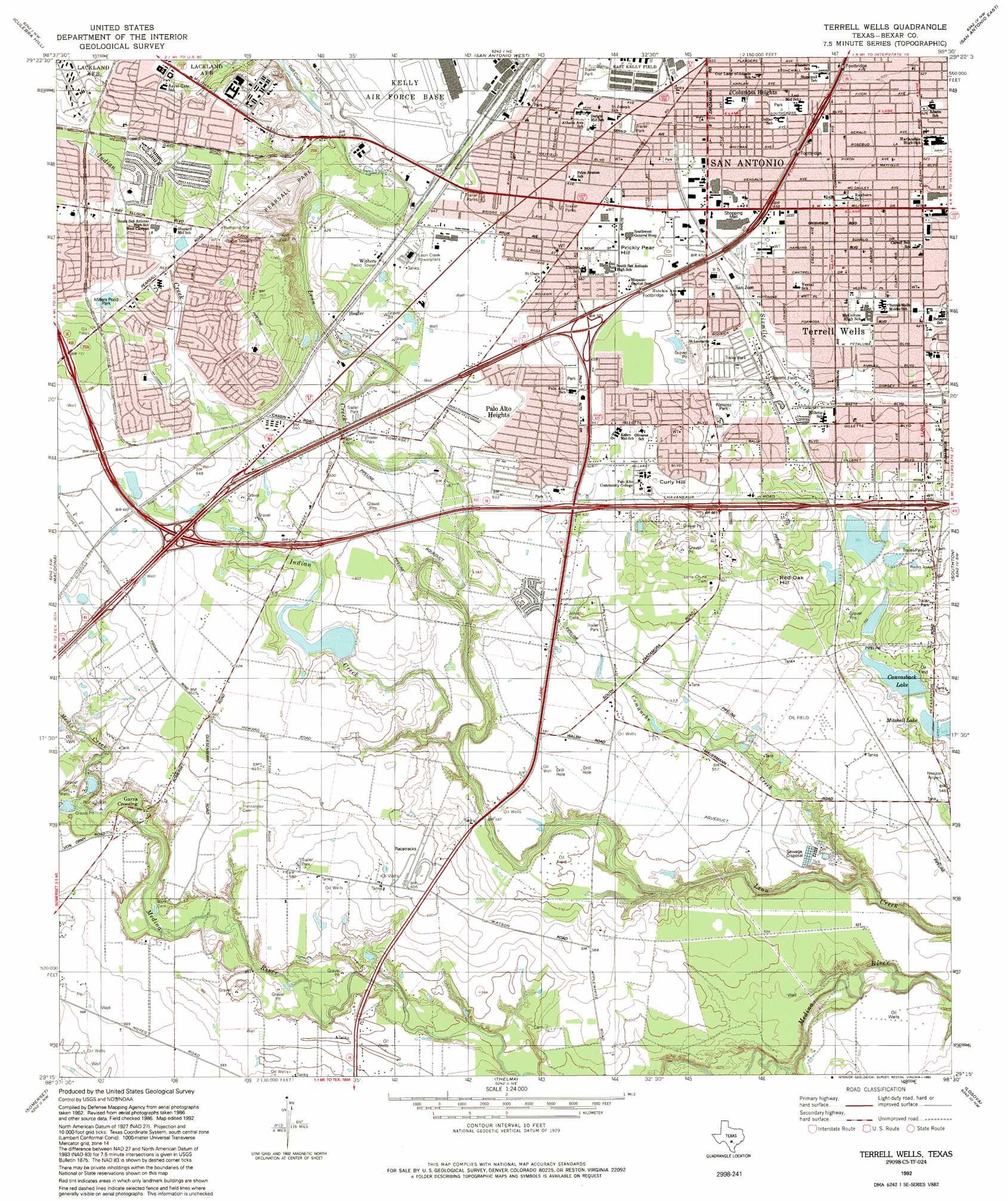
Terrell Wells Topo Map Texas
To zoom in, hover over the map of Terrell Wells
USGS Topo Quad 29098c5 - 1:24,000 scale
| Topo Map Name: | Terrell Wells |
| USGS Topo Quad ID: | 29098c5 |
| Print Size: | ca. 21 1/4" wide x 27" high |
| Southeast Coordinates: | 29.25° N latitude / 98.5° W longitude |
| Map Center Coordinates: | 29.3125° N latitude / 98.5625° W longitude |
| U.S. State: | TX |
| Filename: | o29098c5.jpg |
| Download Map JPG Image: | Terrell Wells topo map 1:24,000 scale |
| Map Type: | Topographic |
| Topo Series: | 7.5´ |
| Map Scale: | 1:24,000 |
| Source of Map Images: | United States Geological Survey (USGS) |
| Alternate Map Versions: |
Terrell Wells TX 1953, updated 1959 Download PDF Buy paper map Terrell Wells TX 1967, updated 1969 Download PDF Buy paper map Terrell Wells TX 1967, updated 1975 Download PDF Buy paper map Terrell Wells TX 1967, updated 1975 Download PDF Buy paper map Terrell Wells TX 1992, updated 1992 Download PDF Buy paper map Terrell Wells TX 1992, updated 1992 Download PDF Buy paper map Terrell Wells TX 2010 Download PDF Buy paper map Terrell Wells TX 2013 Download PDF Buy paper map Terrell Wells TX 2016 Download PDF Buy paper map |
1:24,000 Topo Quads surrounding Terrell Wells
San Geronimo |
Helotes |
Castle Hills |
Longhorn |
Schertz |
Lacoste Ne |
Culebra Hill |
San Antonio West |
San Antonio East |
Martinez |
Lacoste |
Macdona |
Terrell Wells |
Southton |
Elmendorf |
Lytle |
Somerset |
Thelma |
Losoya |
Saspamco |
Bigfoot |
Rossville |
Poteet |
Leming |
Saspamco Se |
> Back to 29098a1 at 1:100,000 scale
> Back to 29098a1 at 1:250,000 scale
> Back to U.S. Topo Maps home
Terrell Wells topo map: Gazetteer
Terrell Wells: Airports
H B Zachry Heliport elevation 194m 636′Horizon Airport elevation 163m 534′
Terrell Wells: Crossings
Interchange 1 elevation 202m 662′Interchange 144 elevation 194m 636′
Interchange 145A elevation 190m 623′
Interchange 145B elevation 196m 643′
Interchange 146 elevation 190m 623′
Interchange 147 elevation 193m 633′
Interchange 148A and 148B elevation 201m 659′
Interchange 149 elevation 195m 639′
Interchange 150B elevation 195m 639′
Interchange 2 elevation 217m 711′
Interchange 46 elevation 184m 603′
Interchange 48 elevation 196m 643′
Interchange 49 elevation 187m 613′
Interchange 51 elevation 185m 606′
Interchange 53 elevation 191m 626′
Terrell Wells: Dams
Ballasetal Lake Dam elevation 173m 567′Canvasback Lake Dam elevation 165m 541′
Kilroy Lake Dam elevation 176m 577′
Terrell Wells: Parks
Forge Park elevation 190m 623′Hutchins Park elevation 188m 616′
Millers Pond Park elevation 205m 672′
Palo Alto Park elevation 200m 656′
Palo Alto Terrace Park elevation 199m 652′
Pearsall Park elevation 216m 708′
Ramirez Park elevation 188m 616′
Royal Gate Park elevation 222m 728′
South San Park elevation 202m 662′
South San Pedro Park elevation 203m 666′
South San Stadium elevation 204m 669′
Southcross Park elevation 194m 636′
Terrell Wells: Populated Places
Columbia Heights elevation 197m 646′Garza Crossing elevation 162m 531′
Heafer elevation 187m 613′
Palo Alto Heights elevation 191m 626′
Palo Alto Park elevation 198m 649′
San Jose elevation 189m 620′
Terrell Wells elevation 188m 616′
Withers elevation 192m 629′
Terrell Wells: Post Offices
Tejeda Station Post Office elevation 200m 656′Terrell Wells: Reservoirs
Ballasetal Lake elevation 173m 567′Canvasback Lake elevation 165m 541′
Kilroy Lake elevation 176m 577′
Terrell Wells: Streams
Comanche Creek elevation 144m 472′Elm Creek elevation 150m 492′
Indian Creek elevation 164m 538′
Medio Creek elevation 163m 534′
Terrell Wells: Summits
Curly Hill elevation 205m 672′Prickly Pear Hill elevation 201m 659′
Red Oak Hill elevation 195m 639′
Terrell Wells digital topo map on disk
Buy this Terrell Wells topo map showing relief, roads, GPS coordinates and other geographical features, as a high-resolution digital map file on DVD: