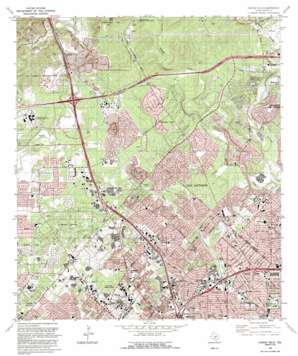
Castle Hills Topo Map Texas
To zoom in, hover over the map of Castle Hills
USGS Topo Quad 29098e5 - 1:24,000 scale
| Topo Map Name: | Castle Hills |
| USGS Topo Quad ID: | 29098e5 |
| Print Size: | ca. 21 1/4" wide x 27" high |
| Southeast Coordinates: | 29.5° N latitude / 98.5° W longitude |
| Map Center Coordinates: | 29.5625° N latitude / 98.5625° W longitude |
| U.S. State: | TX |
| Filename: | o29098e5.jpg |
| Download Map JPG Image: | Castle Hills topo map 1:24,000 scale |
| Map Type: | Topographic |
| Topo Series: | 7.5´ |
| Map Scale: | 1:24,000 |
| Source of Map Images: | United States Geological Survey (USGS) |
| Alternate Map Versions: |
Castle Hills TX 1953, updated 1959 Download PDF Buy paper map Castle Hills TX 1967, updated 1969 Download PDF Buy paper map Castle Hills TX 1967, updated 1975 Download PDF Buy paper map Castle Hills TX 1992, updated 1993 Download PDF Buy paper map Castle Hills TX 1992, updated 1993 Download PDF Buy paper map Castle Hills TX 2010 Download PDF Buy paper map Castle Hills TX 2013 Download PDF Buy paper map Castle Hills TX 2016 Download PDF Buy paper map |
1:24,000 Topo Quads surrounding Castle Hills
> Back to 29098e1 at 1:100,000 scale
> Back to 29098a1 at 1:250,000 scale
> Back to U.S. Topo Maps home
Castle Hills topo map: Gazetteer
Castle Hills: Airports
Bexar County Hospital Heliport elevation 295m 967′Medical Center Hospital Heliport elevation 290m 951′
Methodist Hospital Heliport elevation 312m 1023′
Santa Rosa Northwest Hospital Heliport elevation 284m 931′
Castle Hills: Crossings
Interchange 17A elevation 266m 872′Interchange 17B elevation 260m 853′
Interchange 19A elevation 254m 833′
Interchange 19B elevation 250m 820′
Interchange 555 elevation 320m 1049′
Interchange 556A elevation 306m 1003′
Interchange 556B elevation 301m 987′
Interchange 557 elevation 306m 1003′
Interchange 558 elevation 297m 974′
Interchange 559 elevation 316m 1036′
Interchange 560 elevation 304m 997′
Interchange 561 elevation 282m 925′
Interchange 563 elevation 283m 928′
Interchange 564A elevation 276m 905′
Castle Hills: Dams
Soil Conservation Service Site 4 Dam elevation 303m 994′Castle Hills: Parks
Aggie Park elevation 237m 777′Antonian Stadium elevation 240m 787′
Cornerstone Christian School Football Field and Track elevation 268m 879′
Dellview Park elevation 251m 823′
Eisenhower Park elevation 361m 1184′
Orsinger Park elevation 277m 908′
Rimkus Park elevation 251m 823′
San Antonio Convocation Center - University of Texas elevation 300m 984′
San Antonio Softball Field - University of Texas elevation 301m 987′
Windsor Park elevation 238m 780′
Castle Hills: Populated Places
Beckmann elevation 318m 1043′Castle Hills elevation 256m 839′
Oakland Estates elevation 290m 951′
Robards elevation 249m 816′
Shavano Park elevation 298m 977′
Castle Hills: Post Offices
Cedar Elm Post Office elevation 295m 967′Lockhill Post Office elevation 295m 967′
South Texas Medical Center Post Office elevation 289m 948′
Castle Hills: Reservoirs
Soil Conservation Service Site 4 Reservoir elevation 303m 994′Castle Hills: Springs
Walker Springs elevation 285m 935′Castle Hills: Summits
Ninemile Hill elevation 314m 1030′Castle Hills digital topo map on disk
Buy this Castle Hills topo map showing relief, roads, GPS coordinates and other geographical features, as a high-resolution digital map file on DVD:


