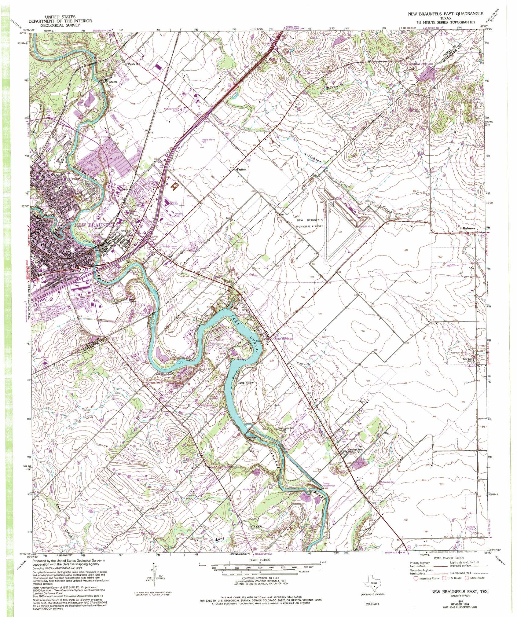
New Braunfels East Topo Map Texas
To zoom in, hover over the map of New Braunfels East
USGS Topo Quad 29098f1 - 1:24,000 scale
| Topo Map Name: | New Braunfels East |
| USGS Topo Quad ID: | 29098f1 |
| Print Size: | ca. 21 1/4" wide x 27" high |
| Southeast Coordinates: | 29.625° N latitude / 98° W longitude |
| Map Center Coordinates: | 29.6875° N latitude / 98.0625° W longitude |
| U.S. State: | TX |
| Filename: | o29098f1.jpg |
| Download Map JPG Image: | New Braunfels East topo map 1:24,000 scale |
| Map Type: | Topographic |
| Topo Series: | 7.5´ |
| Map Scale: | 1:24,000 |
| Source of Map Images: | United States Geological Survey (USGS) |
| Alternate Map Versions: |
New Braunfels East TX 1958, updated 1961 Download PDF Buy paper map New Braunfels East TX 1958, updated 1975 Download PDF Buy paper map New Braunfels East TX 1958, updated 1994 Download PDF Buy paper map New Braunfels East TX 2010 Download PDF Buy paper map New Braunfels East TX 2013 Download PDF Buy paper map New Braunfels East TX 2016 Download PDF Buy paper map |
1:24,000 Topo Quads surrounding New Braunfels East
Fischer |
Devils Backbone |
Wimberley |
San Marcos North |
Uhland |
Smithson Valley |
Sattler |
Hunter |
San Marcos South |
Martindale |
Bat Cave |
New Braunfels West |
New Braunfels East |
Geronimo |
Kingsbury |
Schertz |
Marion |
Mcqueeney |
Seguin |
Darst Creek |
Martinez |
Saint Hedwig |
New Berlin |
Thomas Springs |
Dewville |
> Back to 29098e1 at 1:100,000 scale
> Back to 29098a1 at 1:250,000 scale
> Back to U.S. Topo Maps home
New Braunfels East topo map: Gazetteer
New Braunfels East: Airports
New Braunfels Municipal Airport elevation 197m 646′New Braunfels East: Dams
Soil Conservation Service Site 4 Dam elevation 174m 570′Texas Power Company Dam elevation 166m 544′
West Point-Pepperell Dam elevation 179m 587′
New Braunfels East: Falls
Dittmar Falls elevation 165m 541′New Braunfels East: Parks
Comal Park elevation 187m 613′Cypress Bend Park elevation 183m 600′
Fair Park elevation 196m 643′
Guadalupe Valley Memorial Park elevation 182m 597′
Lamar Park elevation 199m 652′
Prince Solms Park elevation 188m 616′
New Braunfels East: Populated Places
Barbarosa elevation 186m 610′Camp Willow elevation 179m 587′
Clear Springs elevation 190m 623′
Freiheit elevation 203m 666′
Gruene elevation 206m 675′
Lake Dunlap elevation 180m 590′
New Braunfels elevation 192m 629′
Preiss Heights elevation 218m 715′
Schumannsville elevation 192m 629′
Thorn Hill elevation 205m 672′
New Braunfels East: Reservoirs
Lake Dunlap elevation 166m 544′Soil Conservation Service Site 4 Reservoir elevation 174m 570′
West Point-Pepperell Lake elevation 179m 587′
New Braunfels East: Streams
Comal River elevation 179m 587′New Braunfels East digital topo map on disk
Buy this New Braunfels East topo map showing relief, roads, GPS coordinates and other geographical features, as a high-resolution digital map file on DVD: