New Braunfels West Topo Map Texas
To zoom in, hover over the map of New Braunfels West
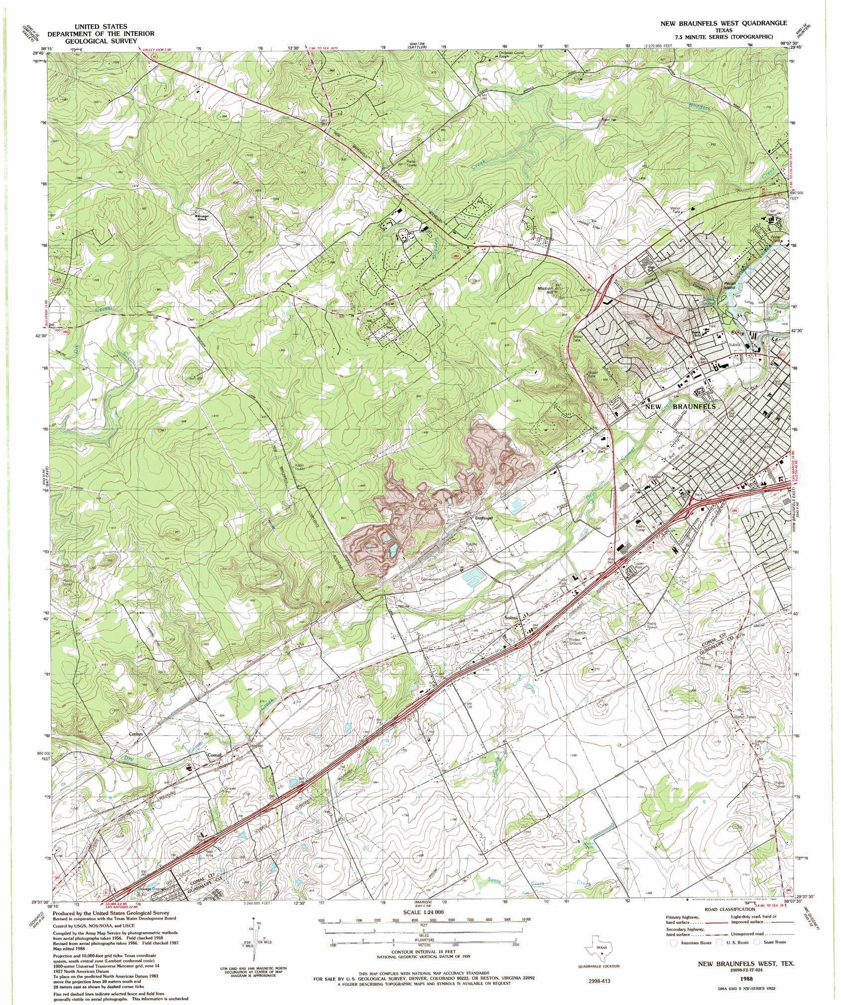
USGS Topo Quad 29098f2 - 1:24,000 scale
| Topo Map Name: | New Braunfels West |
| USGS Topo Quad ID: | 29098f2 |
| Print Size: | ca. 21 1/4" wide x 27" high |
| Southeast Coordinates: | 29.625° N latitude / 98.125° W longitude |
| Map Center Coordinates: | 29.6875° N latitude / 98.1875° W longitude |
| U.S. State: | TX |
| Filename: | o29098f2.jpg |
| Download Map JPG Image: | New Braunfels West topo map 1:24,000 scale |
| Map Type: | Topographic |
| Topo Series: | 7.5´ |
| Map Scale: | 1:24,000 |
| Source of Map Images: | United States Geological Survey (USGS) |
| Alternate Map Versions: |
New Braunfels West TX 1958, updated 1961 Download PDF Buy paper map New Braunfels West TX 1958, updated 1975 Download PDF Buy paper map New Braunfels West TX 1988, updated 1988 Download PDF Buy paper map New Braunfels West TX 1988, updated 1988 Download PDF Buy paper map New Braunfels West TX 2010 Download PDF Buy paper map New Braunfels West TX 2013 Download PDF Buy paper map New Braunfels West TX 2016 Download PDF Buy paper map |
1:24,000 Topo Quads surrounding New Braunfels West
Spring Branch |
Fischer |
Devils Backbone |
Wimberley |
San Marcos North |
Anhalt |
Smithson Valley |
Sattler |
Hunter |
San Marcos South |
Bulverde |
Bat Cave |
New Braunfels West |
New Braunfels East |
Geronimo |
Longhorn |
Schertz |
Marion |
Mcqueeney |
Seguin |
San Antonio East |
Martinez |
Saint Hedwig |
New Berlin |
Thomas Springs |
> Back to 29098e1 at 1:100,000 scale
> Back to 29098a1 at 1:250,000 scale
> Back to U.S. Topo Maps home
New Braunfels West topo map: Gazetteer
New Braunfels West: Airports
Fox Airport elevation 202m 662′Hilltop Ranch Airport elevation 217m 711′
McCoy Building Sup 16 Heliport elevation 195m 639′
New Braunfels West: Dams
Soil Conservation Service Site 3 Dam elevation 225m 738′New Braunfels West: Islands
Pecan Island elevation 189m 620′New Braunfels West: Parks
H E B Park elevation 197m 646′Landa Park elevation 186m 610′
Unicorn Stadium elevation 255m 836′
New Braunfels West: Populated Places
Comal elevation 211m 692′Corbyn elevation 214m 702′
Dittlinger elevation 212m 695′
Jentsch Acres elevation 201m 659′
Landa Park Highlands elevation 234m 767′
Solms elevation 202m 662′
New Braunfels West: Reservoirs
Soil Conservation Service Site 3 Reservoir elevation 225m 738′New Braunfels West: Springs
Comal Springs elevation 242m 793′New Braunfels West: Streams
Blieders Creek elevation 192m 629′Dry Comal Creek elevation 182m 597′
Fourmile Creek elevation 193m 633′
New Braunfels West: Summits
Mission Hill elevation 292m 958′New Braunfels West: Trails
Landa Park Trail elevation 189m 620′Panther Canyon Trail elevation 194m 636′
New Braunfels West: Valleys
Panther Canyon elevation 192m 629′New Braunfels West: Wells
Marion Wells elevation 212m 695′New Braunfels West digital topo map on disk
Buy this New Braunfels West topo map showing relief, roads, GPS coordinates and other geographical features, as a high-resolution digital map file on DVD: