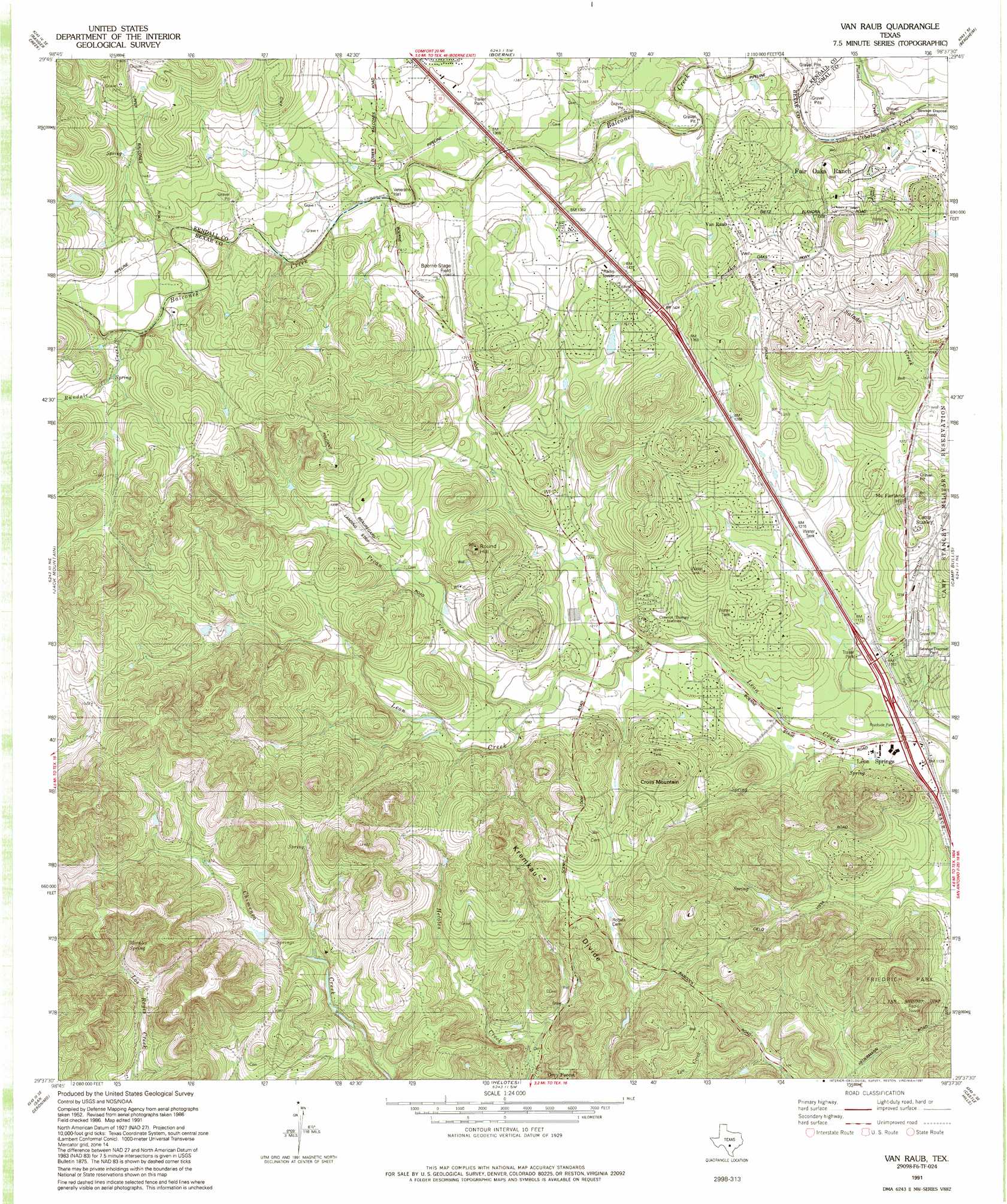
Van Raub Topo Map Texas
To zoom in, hover over the map of Van Raub
USGS Topo Quad 29098f6 - 1:24,000 scale
| Topo Map Name: | Van Raub |
| USGS Topo Quad ID: | 29098f6 |
| Print Size: | ca. 21 1/4" wide x 27" high |
| Southeast Coordinates: | 29.625° N latitude / 98.625° W longitude |
| Map Center Coordinates: | 29.6875° N latitude / 98.6875° W longitude |
| U.S. State: | TX |
| Filename: | o29098f6.jpg |
| Download Map JPG Image: | Van Raub topo map 1:24,000 scale |
| Map Type: | Topographic |
| Topo Series: | 7.5´ |
| Map Scale: | 1:24,000 |
| Source of Map Images: | United States Geological Survey (USGS) |
| Alternate Map Versions: |
Van Raub TX 1953, updated 1959 Download PDF Buy paper map Van Raub TX 1967, updated 1969 Download PDF Buy paper map Van Raub TX 1967, updated 1975 Download PDF Buy paper map Van Raub TX 1967, updated 1982 Download PDF Buy paper map Van Raub TX 1991, updated 1991 Download PDF Buy paper map Van Raub TX 2010 Download PDF Buy paper map Van Raub TX 2013 Download PDF Buy paper map Van Raub TX 2016 Download PDF Buy paper map |
1:24,000 Topo Quads surrounding Van Raub
Comfort |
Waring |
Sisterdale |
Kendalia |
Spring Branch |
Turkey Knob |
Ranger Creek |
Boerne |
Bergheim |
Anhalt |
Pipe Creek |
Jack Mountain |
Van Raub |
Camp Bullis |
Bulverde |
Medina Lake |
San Geronimo |
Helotes |
Castle Hills |
Longhorn |
Riomedina |
Lacoste Ne |
Culebra Hill |
San Antonio West |
San Antonio East |
> Back to 29098e1 at 1:100,000 scale
> Back to 29098a1 at 1:250,000 scale
> Back to U.S. Topo Maps home
Van Raub topo map: Gazetteer
Van Raub: Airports
Boerne Stage Field elevation 420m 1377′Tarry Bank Airport elevation 413m 1354′
Van Raub: Crossings
Interchange 546 elevation 427m 1400′Interchange 550 elevation 354m 1161′
Interchange 554 elevation 342m 1122′
Van Raub: Dams
Lakeside Acres Club Lake Dam elevation 412m 1351′White Company Lake Dam elevation 396m 1299′
Van Raub: Parks
Friedrich Park elevation 384m 1259′Van Raub: Populated Places
Cross Mountain elevation 426m 1397′Fair Oaks Ranch elevation 387m 1269′
Leon Springs elevation 344m 1128′
Scenic Oaks elevation 404m 1325′
Van Raub elevation 418m 1371′
Van Raub: Reservoirs
Lakeside Acres Club Lake elevation 412m 1351′White Company Lake elevation 396m 1299′
Van Raub: Ridges
Kremkau Divide elevation 413m 1354′Van Raub: Springs
Morales Spring elevation 432m 1417′Van Raub: Streams
Balcones Creek elevation 381m 1250′Pecan Creek elevation 376m 1233′
Postoak Creek elevation 376m 1233′
Rundale Creek elevation 442m 1450′
Van Raub: Summits
Cross Mountain elevation 460m 1509′McFarland Hill elevation 419m 1374′
Round Hill elevation 465m 1525′
Van Raub: Trails
Friedrich Wilderness Park Trail Network elevation 384m 1259′Van Raub digital topo map on disk
Buy this Van Raub topo map showing relief, roads, GPS coordinates and other geographical features, as a high-resolution digital map file on DVD: