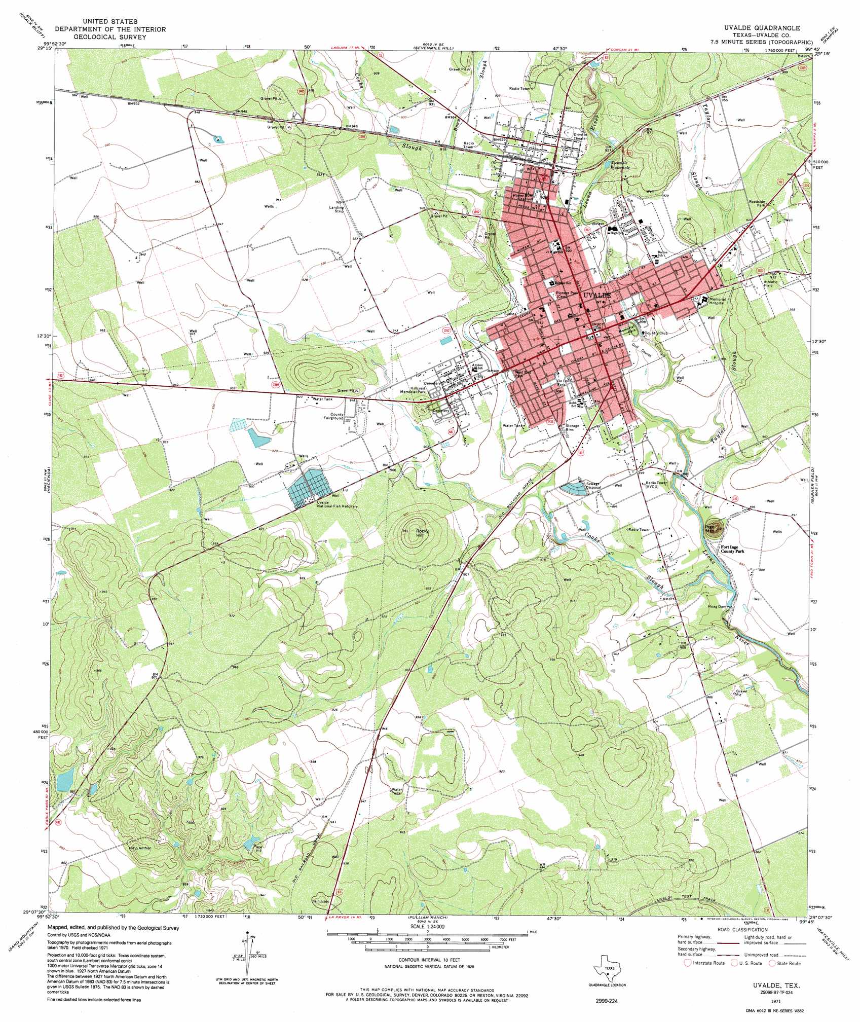
Uvalde Topo Map Texas
To zoom in, hover over the map of Uvalde
USGS Topo Quad 29099b7 - 1:24,000 scale
| Topo Map Name: | Uvalde |
| USGS Topo Quad ID: | 29099b7 |
| Print Size: | ca. 21 1/4" wide x 27" high |
| Southeast Coordinates: | 29.125° N latitude / 99.75° W longitude |
| Map Center Coordinates: | 29.1875° N latitude / 99.8125° W longitude |
| U.S. State: | TX |
| Filename: | o29099b7.jpg |
| Download Map JPG Image: | Uvalde topo map 1:24,000 scale |
| Map Type: | Topographic |
| Topo Series: | 7.5´ |
| Map Scale: | 1:24,000 |
| Source of Map Images: | United States Geological Survey (USGS) |
| Alternate Map Versions: |
Uvalde TX 1971, updated 1974 Download PDF Buy paper map Uvalde TX 1971, updated 1992 Download PDF Buy paper map Uvalde TX 2010 Download PDF Buy paper map Uvalde TX 2013 Download PDF Buy paper map Uvalde TX 2016 Download PDF Buy paper map |
1:24,000 Topo Quads surrounding Uvalde
Laguna |
Sycamore Mountain |
Deep Creek |
Concan |
Trio |
Mustang Waterhole |
Chalk Bluff |
Sevenmile Hill |
Knippa |
Blanco Lake |
Cline |
Hacienda |
Uvalde |
Garner Field |
Garner Field Ne |
Olmos Creek |
Sand Mountain |
Pulliam Ranch |
Batesville Hill |
Lone Tree Hill |
Chacon Creek Ne |
La Pryor Nw |
La Pryor |
Batesville Nw |
Batesville |
> Back to 29099a1 at 1:100,000 scale
> Back to 29098a1 at 1:250,000 scale
> Back to U.S. Topo Maps home
Uvalde topo map: Gazetteer
Uvalde: Airports
Uvalde County Hospital Authority Heliport elevation 280m 918′Uvalde: Bays
Twomile Waterhole elevation 276m 905′Uvalde: Dams
Hoag Dam elevation 262m 859′McDaniels Dam elevation 266m 872′
Uvalde: Parks
American Legion Park elevation 282m 925′DeLeon Park elevation 275m 902′
Fort Inge Historical Site County Park elevation 271m 889′
Honey Bowl Stadium elevation 283m 928′
Honey Bowl Stadium elevation 284m 931′
Uvalde: Populated Places
Brice Lane Colonia elevation 275m 902′Fort Clark Road Colonia elevation 278m 912′
Fort Inge elevation 269m 882′
Gonzales Colonia elevation 275m 902′
North Uvalde Colonia elevation 282m 925′
South Grove Street Colonia elevation 276m 905′
Uvalde elevation 277m 908′
Uvalde Estates elevation 293m 961′
Uvalde Estates Colonia elevation 295m 967′
Vanessa Street Colonia elevation 275m 902′
Vanham Addition Colonia elevation 286m 938′
Uvalde: Reservoirs
Hoag Lake elevation 263m 862′McDaniels Tank elevation 266m 872′
Uvalde: Springs
Leona Springs elevation 272m 892′Leona Springs elevation 278m 912′
Uvalde: Streams
Boon Slough elevation 280m 918′Cooks Slough elevation 263m 862′
Taylor Slough elevation 264m 866′
Uvalde: Summits
Inge Mountain elevation 309m 1013′Rocky Hill elevation 298m 977′
Uvalde digital topo map on disk
Buy this Uvalde topo map showing relief, roads, GPS coordinates and other geographical features, as a high-resolution digital map file on DVD: