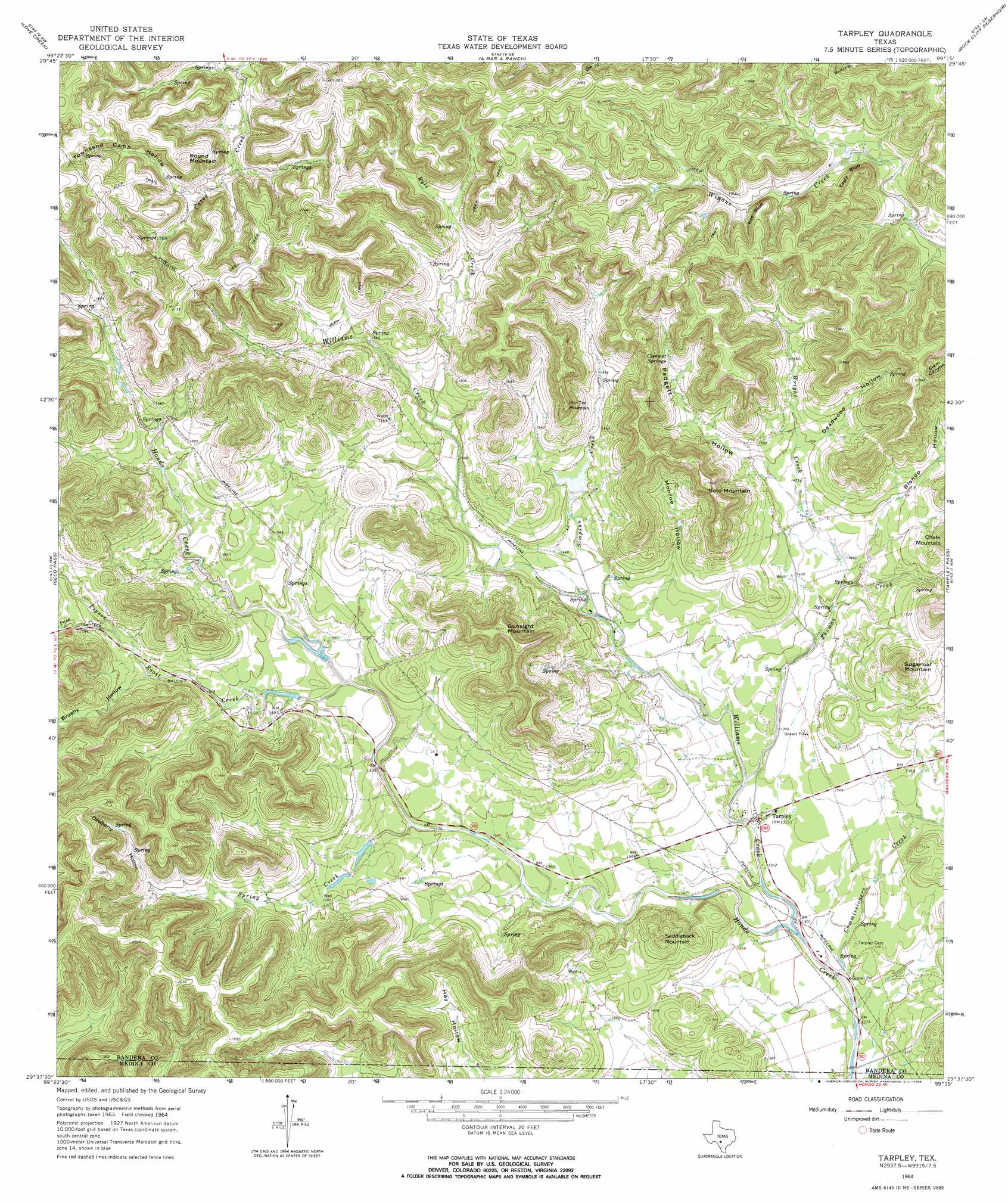
Tarpley Topo Map Texas
To zoom in, hover over the map of Tarpley
USGS Topo Quad 29099f3 - 1:24,000 scale
| Topo Map Name: | Tarpley |
| USGS Topo Quad ID: | 29099f3 |
| Print Size: | ca. 21 1/4" wide x 27" high |
| Southeast Coordinates: | 29.625° N latitude / 99.25° W longitude |
| Map Center Coordinates: | 29.6875° N latitude / 99.3125° W longitude |
| U.S. State: | TX |
| Filename: | o29099f3.jpg |
| Download Map JPG Image: | Tarpley topo map 1:24,000 scale |
| Map Type: | Topographic |
| Topo Series: | 7.5´ |
| Map Scale: | 1:24,000 |
| Source of Map Images: | United States Geological Survey (USGS) |
| Alternate Map Versions: |
Tarpley TX 1964, updated 1968 Download PDF Buy paper map Tarpley TX 1964, updated 1968 Download PDF Buy paper map Tarpley TX 2010 Download PDF Buy paper map Tarpley TX 2013 Download PDF Buy paper map Tarpley TX 2016 Download PDF Buy paper map |
1:24,000 Topo Quads surrounding Tarpley
Well Hollow |
Diamond S Ranch |
Echo Hill Ranch |
Fall Creek |
Center Point |
Sabinal Canyon |
Love Creek |
A Bar A Ranch |
Rock Cliff Reservoir |
Bandera Pass |
Vanderpool |
Seco Pass |
Tarpley |
Tarpley Pass |
Bandera |
Utopia |
Flatrock Crossing |
Texas Mountain |
Twin Hollow |
Timber Creek |
Trio |
Comanche Waterhole |
Sabinal Ne |
Mustang Valley |
Quihi |
> Back to 29099e1 at 1:100,000 scale
> Back to 29098a1 at 1:250,000 scale
> Back to U.S. Topo Maps home
Tarpley topo map: Gazetteer
Tarpley: Airports
Twin Falls Ranch Airport elevation 440m 1443′Tarpley: Cliffs
Bee Bluff elevation 544m 1784′Eagle Bluff elevation 540m 1771′
Tarpley: Dams
McClennahan Lake 1 Dam elevation 439m 1440′McClennahan Lake 2 Dam elevation 444m 1456′
Shadow Dance Ranch Dam elevation 479m 1571′
Voss Lake Dam elevation 446m 1463′
Tarpley: Populated Places
Tarpley elevation 403m 1322′Tarpley: Reservoirs
McClennahan Lake 1 elevation 439m 1440′McClennahan Lake 2 elevation 444m 1456′
Shadow Dance Ranch Lake elevation 479m 1571′
Voss Lake elevation 446m 1463′
Tarpley: Streams
Commissioners Creek elevation 384m 1259′Pass Creek elevation 475m 1558′
Pigeon Roost Creek elevation 430m 1410′
Ryle Creek elevation 452m 1482′
Simpson Creek elevation 421m 1381′
Spring Creek elevation 419m 1374′
Thomas Creek elevation 401m 1315′
Walker Creek elevation 546m 1791′
Williams Creek elevation 390m 1279′
Wright Creek elevation 424m 1391′
Tarpley: Summits
Gunsight Mountain elevation 590m 1935′Iron Top Mountain elevation 584m 1916′
Round Mountain elevation 648m 2125′
Saddleback Mountain elevation 523m 1715′
Soto Mountain elevation 594m 1948′
Sugarloaf Mountain elevation 577m 1893′
Tarpley: Valleys
Bishop Hollow elevation 444m 1456′Brushy Hollow elevation 469m 1538′
Deadwood Hollow elevation 456m 1496′
Dewberry Hollow elevation 488m 1601′
Monroe Hollow elevation 426m 1397′
Padgett Hollow elevation 451m 1479′
Townsend Camp Hollow elevation 548m 1797′
Tarpley digital topo map on disk
Buy this Tarpley topo map showing relief, roads, GPS coordinates and other geographical features, as a high-resolution digital map file on DVD: