Sabinal Canyon Topo Map Texas
To zoom in, hover over the map of Sabinal Canyon
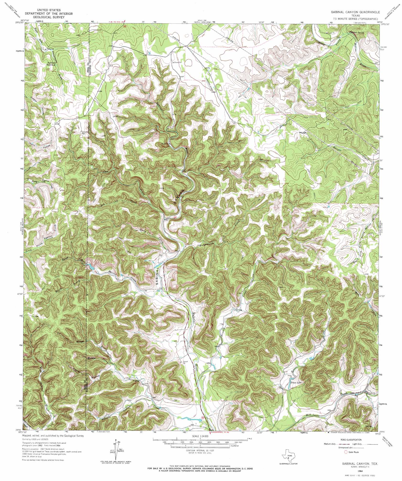
USGS Topo Quad 29099g5 - 1:24,000 scale
| Topo Map Name: | Sabinal Canyon |
| USGS Topo Quad ID: | 29099g5 |
| Print Size: | ca. 21 1/4" wide x 27" high |
| Southeast Coordinates: | 29.75° N latitude / 99.5° W longitude |
| Map Center Coordinates: | 29.8125° N latitude / 99.5625° W longitude |
| U.S. State: | TX |
| Filename: | o29099g5.jpg |
| Download Map JPG Image: | Sabinal Canyon topo map 1:24,000 scale |
| Map Type: | Topographic |
| Topo Series: | 7.5´ |
| Map Scale: | 1:24,000 |
| Source of Map Images: | United States Geological Survey (USGS) |
| Alternate Map Versions: |
Sabinal Canyon TX 1964, updated 1967 Download PDF Buy paper map Sabinal Canyon TX 1964, updated 1967 Download PDF Buy paper map Sabinal Canyon TX 2010 Download PDF Buy paper map Sabinal Canyon TX 2012 Download PDF Buy paper map Sabinal Canyon TX 2016 Download PDF Buy paper map |
1:24,000 Topo Quads surrounding Sabinal Canyon
Earwood Creek |
Garven Store |
Boneyard Draw |
Bee Caves Creek |
Hunt |
Bee Cave Hollow |
Hillcrest Ranch |
Well Hollow |
Diamond S Ranch |
Echo Hill Ranch |
Owl Hollow |
Circle Bluff |
Sabinal Canyon |
Love Creek |
A Bar A Ranch |
Leakey |
Rio Frio |
Vanderpool |
Seco Pass |
Tarpley |
Reagan Wells |
Magers Crossing |
Utopia |
Flatrock Crossing |
Texas Mountain |
> Back to 29099e1 at 1:100,000 scale
> Back to 29098a1 at 1:250,000 scale
> Back to U.S. Topo Maps home
Sabinal Canyon topo map: Gazetteer
Sabinal Canyon: Dams
Pelaez Lake Dam elevation 513m 1683′Sabinal Canyon: Lakes
Pelaez Lake elevation 518m 1699′Post Oak Waterhole elevation 666m 2185′
Sabinal Canyon: Parks
Lost Maples State Natural Area elevation 569m 1866′Sabinal Canyon: Reservoirs
Pelaez Lake elevation 513m 1683′Sabinal Canyon: Springs
Flatrock Spring elevation 628m 2060′Sabinal Canyon: Streams
Brushy Creek elevation 497m 1630′Can Creek elevation 548m 1797′
Dry Can Creek elevation 534m 1751′
Evans Creek elevation 495m 1624′
Marler Creek elevation 525m 1722′
Middle Prong Jerigan Creek elevation 542m 1778′
North Prong Jernigan Creek elevation 542m 1778′
North Prong Marler Creek elevation 561m 1840′
Snow Creek elevation 534m 1751′
South Prong Marler Creek elevation 561m 1840′
Wedgeworth Creek elevation 542m 1778′
Willow Springs Branch elevation 513m 1683′
Sabinal Canyon: Trails
Lost Maples State Natural Area Trails elevation 548m 1797′Sabinal Canyon: Valleys
Fiddler Hollow elevation 538m 1765′Massey Hollow elevation 512m 1679′
Sabinal Canyon elevation 498m 1633′
Sabinal Canyon digital topo map on disk
Buy this Sabinal Canyon topo map showing relief, roads, GPS coordinates and other geographical features, as a high-resolution digital map file on DVD: