Joy Hollow Topo Map Texas
To zoom in, hover over the map of Joy Hollow
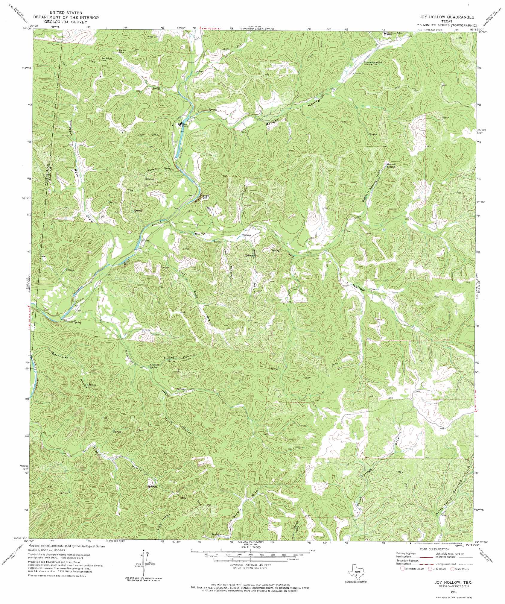
USGS Topo Quad 29099h8 - 1:24,000 scale
| Topo Map Name: | Joy Hollow |
| USGS Topo Quad ID: | 29099h8 |
| Print Size: | ca. 21 1/4" wide x 27" high |
| Southeast Coordinates: | 29.875° N latitude / 99.875° W longitude |
| Map Center Coordinates: | 29.9375° N latitude / 99.9375° W longitude |
| U.S. State: | TX |
| Filename: | o29099h8.jpg |
| Download Map JPG Image: | Joy Hollow topo map 1:24,000 scale |
| Map Type: | Topographic |
| Topo Series: | 7.5´ |
| Map Scale: | 1:24,000 |
| Source of Map Images: | United States Geological Survey (USGS) |
| Alternate Map Versions: |
Joy Hollow TX 1971, updated 1974 Download PDF Buy paper map Joy Hollow TX 2010 Download PDF Buy paper map Joy Hollow TX 2012 Download PDF Buy paper map Joy Hollow TX 2016 Download PDF Buy paper map |
1:24,000 Topo Quads surrounding Joy Hollow
Elbow Lake |
Paint Rock Spring |
Bradford Creek |
Horse Camp Waterhole |
Y O Ranch |
Rocksprings |
Devils Sinkhole |
Earwood Creek Sw |
Earwood Creek |
Garven Store |
Cub Lake |
Hackberry |
Joy Hollow |
Bee Cave Hollow |
Hillcrest Ranch |
Half Moon Prairie |
Vance |
Jo Jan Van Camp |
Owl Hollow |
Circle Bluff |
Kelley Peak |
Camp Wood |
Crown Mountain |
Leakey |
Rio Frio |
> Back to 29099e1 at 1:100,000 scale
> Back to 29098a1 at 1:250,000 scale
> Back to U.S. Topo Maps home
Joy Hollow topo map: Gazetteer
Joy Hollow: Cliffs
Eagle Cliff elevation 677m 2221′Joy Hollow: Dams
Eagle Ranch Lake Number 2 Dam elevation 586m 1922′Joy Hollow: Lakes
Blue Hole elevation 574m 1883′Joy Hollow: Mines
Kaolin Mine elevation 635m 2083′Joy Hollow: Reservoirs
Eagle Ranch Lake Number 2 elevation 586m 1922′Joy Hollow: Springs
Barnett Spring elevation 644m 2112′Morriss Spring elevation 587m 1925′
Sanchez Spring elevation 587m 1925′
Joy Hollow: Valleys
Barnett Spring Draw elevation 602m 1975′Cedar Canyon elevation 589m 1932′
East Rose Draw elevation 561m 1840′
Hackberry Hollow elevation 539m 1768′
Haw Hollow elevation 580m 1902′
Home Hollow elevation 585m 1919′
Horse Hollow elevation 593m 1945′
Joy Hollow elevation 562m 1843′
Mullen Hollow elevation 571m 1873′
Ranger Hollow elevation 585m 1919′
Sanchez Draw elevation 550m 1804′
Turkey Canyon elevation 575m 1886′
West Rose Draw elevation 559m 1833′
Joy Hollow digital topo map on disk
Buy this Joy Hollow topo map showing relief, roads, GPS coordinates and other geographical features, as a high-resolution digital map file on DVD: