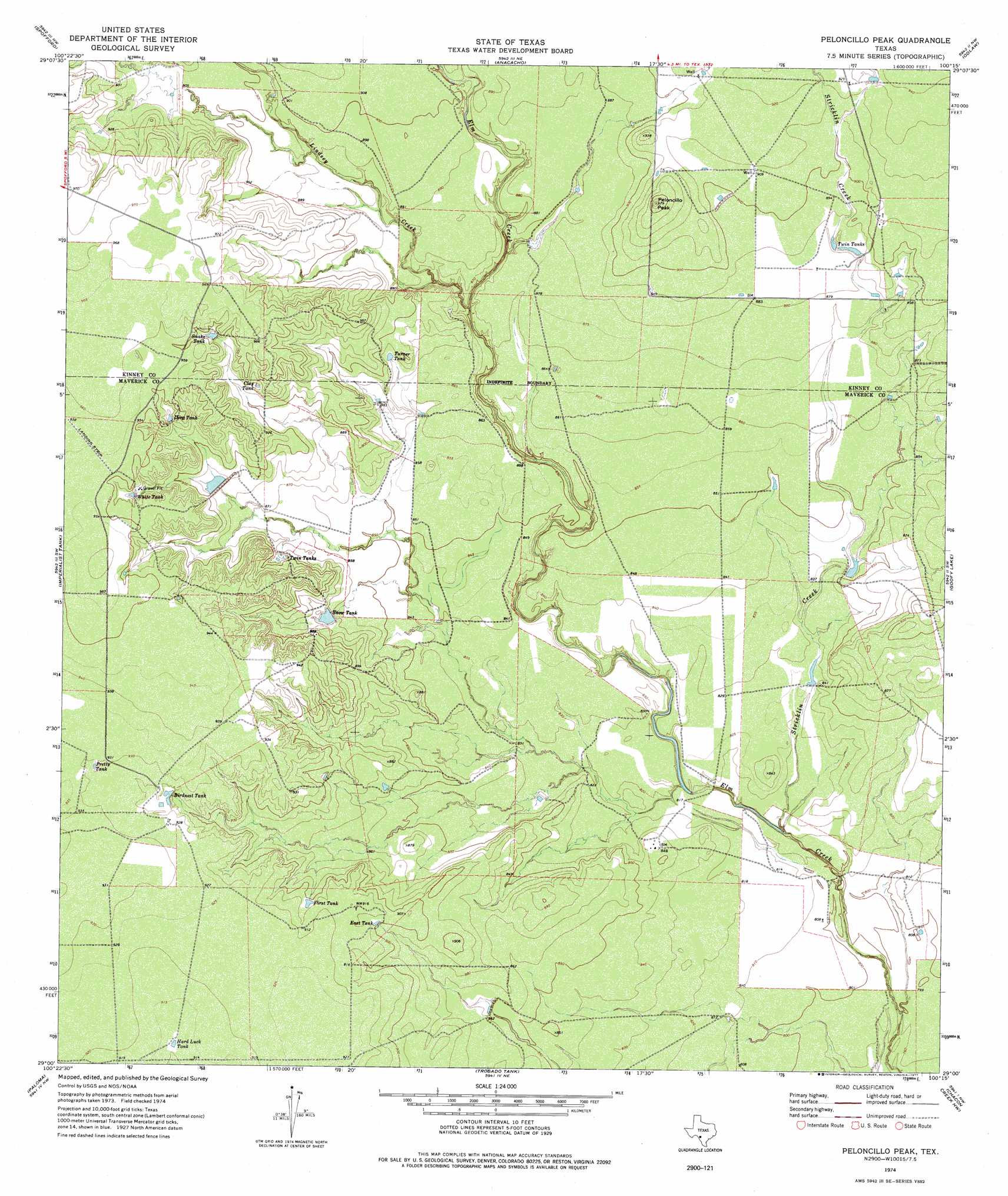
Peloncillo Peak Topo Map Texas
To zoom in, hover over the map of Peloncillo Peak
USGS Topo Quad 29100a3 - 1:24,000 scale
| Topo Map Name: | Peloncillo Peak |
| USGS Topo Quad ID: | 29100a3 |
| Print Size: | ca. 21 1/4" wide x 27" high |
| Southeast Coordinates: | 29° N latitude / 100.25° W longitude |
| Map Center Coordinates: | 29.0625° N latitude / 100.3125° W longitude |
| U.S. State: | TX |
| Filename: | o29100a3.jpg |
| Download Map JPG Image: | Peloncillo Peak topo map 1:24,000 scale |
| Map Type: | Topographic |
| Topo Series: | 7.5´ |
| Map Scale: | 1:24,000 |
| Source of Map Images: | United States Geological Survey (USGS) |
| Alternate Map Versions: |
Peloncillo Peak TX 1974, updated 1977 Download PDF Buy paper map Peloncillo Peak TX 2010 Download PDF Buy paper map Peloncillo Peak TX 2013 Download PDF Buy paper map Peloncillo Peak TX 2016 Download PDF Buy paper map |
1:24,000 Topo Quads surrounding Peloncillo Peak
Standart |
Brackettville |
Elm Mountain |
Turkey Mountain |
Mustang Waterhole |
Tequesquite Creek Ne |
Spofford |
Anacacho |
Odlaw |
Cline |
Tequesquite Spring |
Imperialist Tank |
Peloncillo Peak |
Goofy Lake |
Olmos Creek |
Quemado East |
Paloma |
Trosado Tank |
Chacon Creek Nw |
Chacon Creek Ne |
Quemado Se |
Deadmans Hill |
Indian Tank |
Chacon Creek Sw |
Chacon Creek Se |
> Back to 29100a1 at 1:100,000 scale
> Back to 29100a1 at 1:250,000 scale
> Back to U.S. Topo Maps home
Peloncillo Peak topo map: Gazetteer
Peloncillo Peak: Dams
Dunbar Lake Dam elevation 277m 908′Peloncillo Peak: Reservoirs
Birdnest Tank elevation 277m 908′Clay Tank elevation 280m 918′
Deep Tank elevation 284m 931′
Dunbar Lake elevation 277m 908′
East Tank elevation 274m 898′
First Tank elevation 275m 902′
Hard Luck Tank elevation 278m 912′
Pretty Tank elevation 284m 931′
Snake Tank elevation 286m 938′
Snow Tank elevation 259m 849′
Turner Tank elevation 268m 879′
Twin Tanks elevation 271m 889′
Twin Tanks elevation 271m 889′
White Tank elevation 283m 928′
Peloncillo Peak: Streams
Lindsey Creek elevation 259m 849′Stricklin Creek elevation 244m 800′
Peloncillo Peak: Summits
Peloncillo Peak elevation 297m 974′Peloncillo Peak digital topo map on disk
Buy this Peloncillo Peak topo map showing relief, roads, GPS coordinates and other geographical features, as a high-resolution digital map file on DVD: