Cline Topo Map Texas
To zoom in, hover over the map of Cline
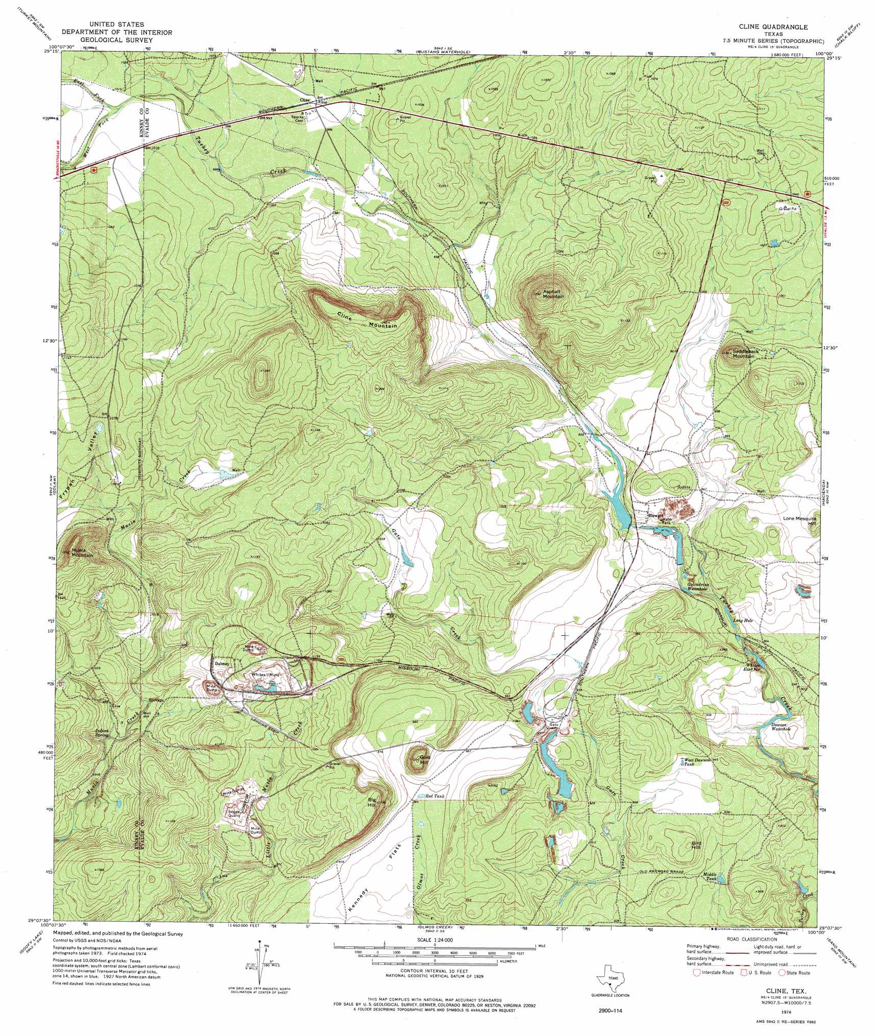
USGS Topo Quad 29100b1 - 1:24,000 scale
| Topo Map Name: | Cline |
| USGS Topo Quad ID: | 29100b1 |
| Print Size: | ca. 21 1/4" wide x 27" high |
| Southeast Coordinates: | 29.125° N latitude / 100° W longitude |
| Map Center Coordinates: | 29.1875° N latitude / 100.0625° W longitude |
| U.S. State: | TX |
| Filename: | o29100b1.jpg |
| Download Map JPG Image: | Cline topo map 1:24,000 scale |
| Map Type: | Topographic |
| Topo Series: | 7.5´ |
| Map Scale: | 1:24,000 |
| Source of Map Images: | United States Geological Survey (USGS) |
| Alternate Map Versions: |
Cline TX 1974, updated 1977 Download PDF Buy paper map Cline TX 2010 Download PDF Buy paper map Cline TX 2012 Download PDF Buy paper map Cline TX 2016 Download PDF Buy paper map |
1:24,000 Topo Quads surrounding Cline
Brackettville Ne |
Salmon Peak |
Laguna |
Sycamore Mountain |
Deep Creek |
Elm Mountain |
Turkey Mountain |
Mustang Waterhole |
Chalk Bluff |
Sevenmile Hill |
Anacacho |
Odlaw |
Cline |
Hacienda |
Uvalde |
Peloncillo Peak |
Goofy Lake |
Olmos Creek |
Sand Mountain |
Pulliam Ranch |
Trosado Tank |
Chacon Creek Nw |
Chacon Creek Ne |
La Pryor Nw |
La Pryor |
> Back to 29100a1 at 1:100,000 scale
> Back to 29100a1 at 1:250,000 scale
> Back to U.S. Topo Maps home
Cline topo map: Gazetteer
Cline: Basins
Frypan Valley elevation 319m 1046′Cline: Dams
Uvalde Rock Asphalt Company Dam elevation 274m 898′White Company Lake Dam elevation 280m 918′
Cline: Flats
Kennedy Flats elevation 282m 925′Cline: Lakes
Dawson Waterhole elevation 260m 853′Whites East Pit elevation 265m 869′
Cline: Mines
Gato Quarry elevation 277m 908′Smyth Quarry elevation 285m 935′
Whites Mine elevation 298m 977′
Cline: Populated Places
Blewett elevation 287m 941′Cline elevation 303m 994′
Dabney elevation 323m 1059′
Cline: Reservoirs
Golondrina Waterhole elevation 271m 889′Long Hole elevation 267m 875′
Middle Tank elevation 271m 889′
Red Tank elevation 287m 941′
Uvalde Rock Asphalt Company Lake elevation 274m 898′
West Dawson Tank elevation 289m 948′
White Company Lake elevation 280m 918′
Cline: Springs
Indian Spring elevation 286m 938′Cline: Streams
East Fork Turkey Creek elevation 306m 1003′West Fork Turkey Creek elevation 306m 1003′
Cline: Summits
Asphalt Mountain elevation 392m 1286′Big Hill elevation 349m 1145′
Bird Hill elevation 297m 974′
Cline Mountain elevation 385m 1263′
Gold Hill elevation 334m 1095′
Lone Mesquite Hill elevation 309m 1013′
Muela Mountain elevation 380m 1246′
Saddleback Mountain elevation 346m 1135′
Cline digital topo map on disk
Buy this Cline topo map showing relief, roads, GPS coordinates and other geographical features, as a high-resolution digital map file on DVD: