Vance Topo Map Texas
To zoom in, hover over the map of Vance
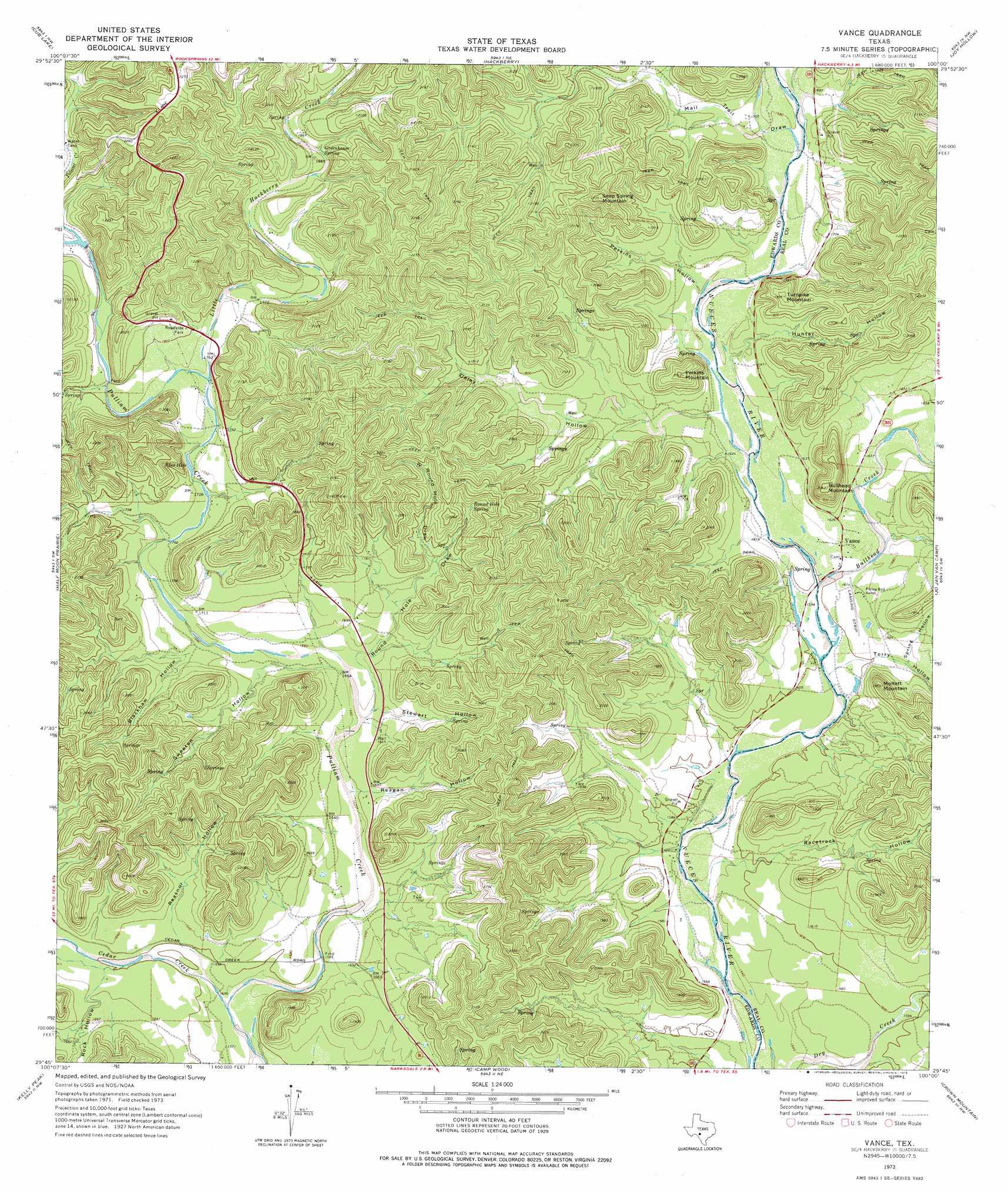
USGS Topo Quad 29100g1 - 1:24,000 scale
| Topo Map Name: | Vance |
| USGS Topo Quad ID: | 29100g1 |
| Print Size: | ca. 21 1/4" wide x 27" high |
| Southeast Coordinates: | 29.75° N latitude / 100° W longitude |
| Map Center Coordinates: | 29.8125° N latitude / 100.0625° W longitude |
| U.S. State: | TX |
| Filename: | o29100g1.jpg |
| Download Map JPG Image: | Vance topo map 1:24,000 scale |
| Map Type: | Topographic |
| Topo Series: | 7.5´ |
| Map Scale: | 1:24,000 |
| Source of Map Images: | United States Geological Survey (USGS) |
| Alternate Map Versions: |
Vance TX 1973, updated 1976 Download PDF Buy paper map Vance TX 2010 Download PDF Buy paper map Vance TX 2012 Download PDF Buy paper map Vance TX 2016 Download PDF Buy paper map |
1:24,000 Topo Quads surrounding Vance
Ray Lake Se |
Rocksprings |
Devils Sinkhole |
Earwood Creek Sw |
Earwood Creek |
Indian Creek Ne |
Cub Lake |
Hackberry |
Joy Hollow |
Bee Cave Hollow |
Cutting Pen Draw |
Half Moon Prairie |
Vance |
Jo Jan Van Camp |
Owl Hollow |
Indian Mountain |
Kelley Peak |
Camp Wood |
Crown Mountain |
Leakey |
Silver Lake |
Bull Waterhole |
Montell |
Lake Creek |
Reagan Wells |
> Back to 29100e1 at 1:100,000 scale
> Back to 29100a1 at 1:250,000 scale
> Back to U.S. Topo Maps home
Vance topo map: Gazetteer
Vance: Lakes
Blue Hole elevation 524m 1719′Vance: Populated Places
Vance elevation 493m 1617′Vance: Springs
Greenhouse Spring elevation 563m 1847′Round Hole Spring elevation 559m 1833′
Vance: Streams
Bullhead Creek elevation 487m 1597′Cedar Creek elevation 479m 1571′
Little Hackberry Creek elevation 529m 1735′
Polecat Creek elevation 552m 1811′
Vance: Summits
Bullhead Mountain elevation 620m 2034′Perkins Mountain elevation 614m 2014′
Seep Spring Mountain elevation 674m 2211′
Turnpike Mountain elevation 601m 1971′
Vance: Valleys
Blackhawk Hollow elevation 517m 1696′Daley Hollow elevation 497m 1630′
Hunter Hollow elevation 500m 1640′
Mail Trail Draw elevation 511m 1676′
Perkins Hollow elevation 501m 1643′
Racetrack Hollow elevation 554m 1817′
Reagan Hollow elevation 503m 1650′
Reasnor Hollow elevation 493m 1617′
Rock Hollow elevation 493m 1617′
Round Hole Draw elevation 499m 1637′
Spring Hollow elevation 495m 1624′
Stewart Hollow elevation 512m 1679′
Sweeten Hollow elevation 509m 1669′
Terry Hollow elevation 485m 1591′
W Round Hole Draw elevation 532m 1745′
Vance digital topo map on disk
Buy this Vance topo map showing relief, roads, GPS coordinates and other geographical features, as a high-resolution digital map file on DVD: