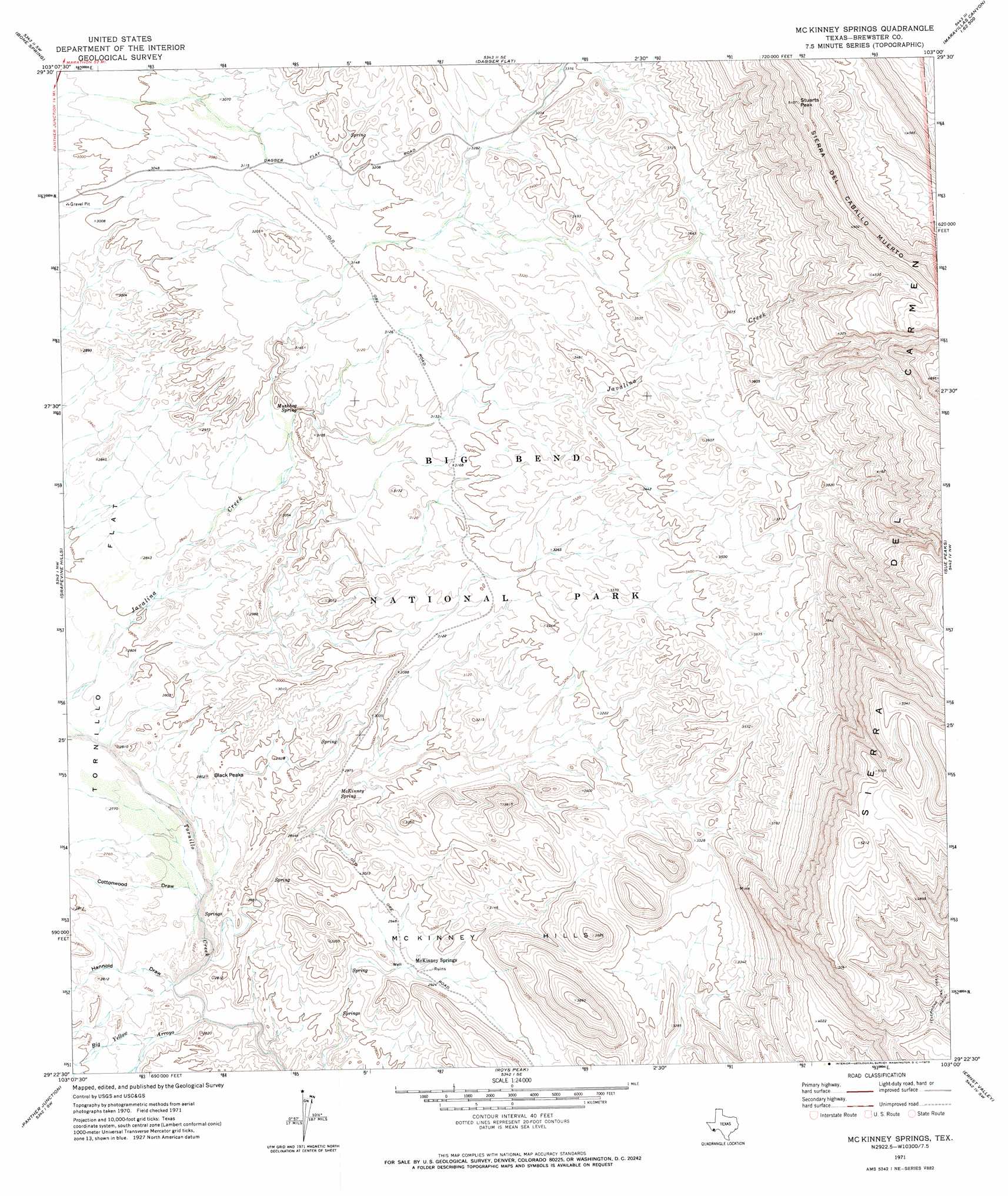
Mckinney Springs Topo Map Texas
To zoom in, hover over the map of Mckinney Springs
USGS Topo Quad 29103d1 - 1:24,000 scale
| Topo Map Name: | Mckinney Springs |
| USGS Topo Quad ID: | 29103d1 |
| Print Size: | ca. 21 1/4" wide x 27" high |
| Southeast Coordinates: | 29.375° N latitude / 103° W longitude |
| Map Center Coordinates: | 29.4375° N latitude / 103.0625° W longitude |
| U.S. State: | TX |
| Filename: | o29103d1.jpg |
| Download Map JPG Image: | Mckinney Springs topo map 1:24,000 scale |
| Map Type: | Topographic |
| Topo Series: | 7.5´ |
| Map Scale: | 1:24,000 |
| Source of Map Images: | United States Geological Survey (USGS) |
| Alternate Map Versions: |
McKinney Springs TX 1971, updated 1973 Download PDF Buy paper map McKinney Springs TX 2010 Download PDF Buy paper map McKinney Springs TX 2012 Download PDF Buy paper map McKinney Springs TX 2016 Download PDF Buy paper map |
1:24,000 Topo Quads surrounding Mckinney Springs
Butterbowl |
Persimmon Gap |
Bone Spring Ne |
Stillwell Mountain |
Cupola Mountain |
Twin Peaks |
Bone Spring |
Dagger Flat |
Black Gap |
Bourland Canyon |
Sombero Peak |
Grapevine Hills |
Mckinney Springs |
Sue Peaks |
Stillwell Crossing |
The Basin |
Panther Junction |
Roys Peak |
Ernst Valley |
|
Emory Peak |
Glenn Spring |
San Vincente |
Boquillas |
> Back to 29103a1 at 1:100,000 scale
> Back to 29102a1 at 1:250,000 scale
> Back to U.S. Topo Maps home
Mckinney Springs topo map: Gazetteer
Mckinney Springs: Populated Places
McKinney Springs elevation 886m 2906′Mckinney Springs: Springs
McKinney Spring elevation 886m 2906′Muskhog Spring elevation 904m 2965′
Mckinney Springs: Streams
Star Creek elevation 839m 2752′Mckinney Springs: Summits
Black Peaks elevation 841m 2759′McKinney Hills elevation 908m 2979′
Stuarts Peak elevation 1545m 5068′
Mckinney Springs: Valleys
Big Yellow Arroyo elevation 813m 2667′Cottonwood Draw elevation 825m 2706′
Hannold Draw elevation 817m 2680′
Mckinney Springs digital topo map on disk
Buy this Mckinney Springs topo map showing relief, roads, GPS coordinates and other geographical features, as a high-resolution digital map file on DVD: