Straddlebug Mountain Topo Map Texas
To zoom in, hover over the map of Straddlebug Mountain
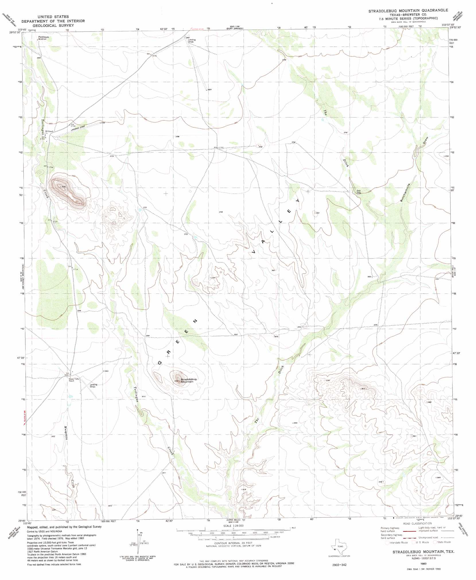
USGS Topo Quad 29103g6 - 1:24,000 scale
| Topo Map Name: | Straddlebug Mountain |
| USGS Topo Quad ID: | 29103g6 |
| Print Size: | ca. 21 1/4" wide x 27" high |
| Southeast Coordinates: | 29.75° N latitude / 103.625° W longitude |
| Map Center Coordinates: | 29.8125° N latitude / 103.6875° W longitude |
| U.S. State: | TX |
| Filename: | o29103g6.jpg |
| Download Map JPG Image: | Straddlebug Mountain topo map 1:24,000 scale |
| Map Type: | Topographic |
| Topo Series: | 7.5´ |
| Map Scale: | 1:24,000 |
| Source of Map Images: | United States Geological Survey (USGS) |
| Alternate Map Versions: |
Straddlebug Mountain TX 1983, updated 1984 Download PDF Buy paper map Straddlebug Mountain TX 2010 Download PDF Buy paper map Straddlebug Mountain TX 2012 Download PDF Buy paper map Straddlebug Mountain TX 2016 Download PDF Buy paper map |
1:24,000 Topo Quads surrounding Straddlebug Mountain
Devils Den |
Cactus Flat |
Goat Mountain |
Elephant Mountain |
Rock House Gap |
Jordan Gap |
Paradise Draw |
Duff Springs |
Whirlwind Spring |
Paso Del Norte |
Puerto Potrillo |
Mckinney Mountain |
Straddlebug Mountain |
Buck Hill |
Santiago Peak |
Horseshoe Mountain |
Bandera Mesa North |
Long Hills |
Dog Canyon |
Graytop |
La Mota Mountain |
Bandero Mesa South |
Agua Fria Mountain |
Packsaddle Mountain |
White Hills |
> Back to 29103e1 at 1:100,000 scale
> Back to 29102a1 at 1:250,000 scale
> Back to U.S. Topo Maps home
Straddlebug Mountain topo map: Gazetteer
Straddlebug Mountain: Airports
02 Ranch Airport elevation 1173m 3848′Straddlebug Mountain: Basins
Green Valley elevation 1108m 3635′Straddlebug Mountain: Populated Places
Loy Place elevation 1105m 3625′Sid Place elevation 1128m 3700′
Straddlebug Mountain: Streams
The Ditch elevation 1079m 3540′Straddlebug Mountain: Summits
Straddlebug Mountain elevation 1153m 3782′Straddlebug Mountain: Valleys
Butcherknife Draw elevation 1111m 3645′Calamity Creek Wash elevation 1112m 3648′
Straddlebug Mountain digital topo map on disk
Buy this Straddlebug Mountain topo map showing relief, roads, GPS coordinates and other geographical features, as a high-resolution digital map file on DVD: