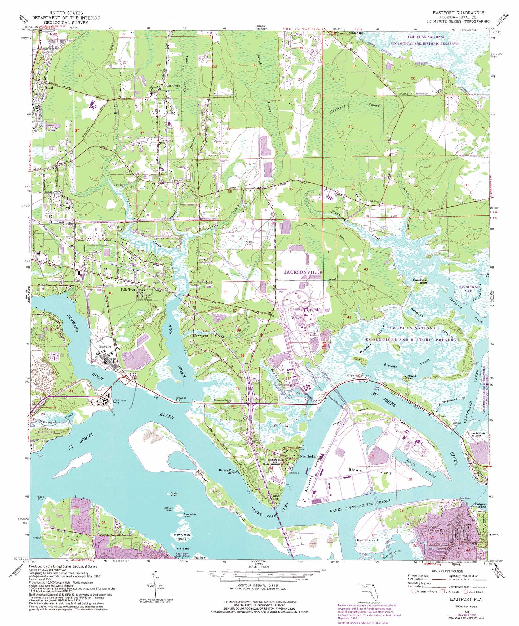
Eastport Topo Map Florida
To zoom in, hover over the map of Eastport
USGS Topo Quad 30081d5 - 1:24,000 scale
| Topo Map Name: | Eastport |
| USGS Topo Quad ID: | 30081d5 |
| Print Size: | ca. 21 1/4" wide x 27" high |
| Southeast Coordinates: | 30.375° N latitude / 81.5° W longitude |
| Map Center Coordinates: | 30.4375° N latitude / 81.5625° W longitude |
| U.S. State: | FL |
| Filename: | O30081D5.jpg |
| Download Map JPG Image: | Eastport topo map 1:24,000 scale |
| Map Type: | Topographic |
| Topo Series: | 7.5´ |
| Map Scale: | 1:24,000 |
| Source of Map Images: | United States Geological Survey (USGS) |
| Alternate Map Versions: |
Eastport FL 1948, updated 1962 Download PDF Buy paper map Eastport FL 1950 Download PDF Buy paper map Eastport FL 1964, updated 1966 Download PDF Buy paper map Eastport FL 1964, updated 1972 Download PDF Buy paper map Eastport FL 1964, updated 1982 Download PDF Buy paper map EastPort FL 1964, updated 1987 Download PDF Buy paper map Eastport FL 1964, updated 1992 Download PDF Buy paper map Eastport FL 1964, updated 1992 Download PDF Buy paper map Eastport FL 1994, updated 2003 Download PDF Buy paper map Eastport FL 2012 Download PDF Buy paper map Eastport FL 2015 Download PDF Buy paper map |
1:24,000 Topo Quads surrounding Eastport
Hilliard Ne |
Gross |
Saint Marys |
Fernandina Beach |
|
Callahan |
Italia |
Hedges |
Amelia City |
|
Dinsmore |
Trout River |
Eastport |
Mayport |
|
Marietta |
Jacksonville |
Arlington |
Jacksonville Beach |
|
Jacksonville Heights |
Orange Park |
Bayard |
Palm Valley |
Mickler Landing |
> Back to 30081a1 at 1:100,000 scale
> Back to 30080a1 at 1:250,000 scale
> Back to U.S. Topo Maps home
Eastport topo map: Gazetteer
Eastport: Airports
Berlin Heliport elevation 3m 9′Eastport: Bays
Alligator Creek elevation 0m 0′Back River elevation 0m 0′
Browns Creek elevation 0m 0′
Little Clapboard Creek elevation 3m 9′
Eastport: Bends
Dames Point Turn elevation 0m 0′Eastport: Capes
Broward Point elevation 0m 0′Dames Point elevation 3m 9′
Drummond Point elevation 1m 3′
Reddie Point elevation 0m 0′
Eastport: Channels
Blount Island Channel elevation 0m 0′Blount Island Channel elevation 0m 0′
Brills Cut Range elevation 0m 0′
Broward Point Turn elevation 0m 0′
Dames Point - Fulton Cutoff elevation 0m 0′
Drummond Creek Range elevation 0m 0′
Quarantine Island Upper Range elevation 0m 0′
Trout River Cut Range elevation 0m 0′
Eastport: Islands
Alligator Island elevation 3m 9′Bartram Island elevation 3m 9′
Blount Island elevation 0m 0′
Browns Island elevation 2m 6′
Buckhorn Bluff elevation 3m 9′
Calypso Island elevation 3m 9′
Crab Island elevation 0m 0′
Fip Island elevation 0m 0′
Le Baron Island elevation 6m 19′
New Castle Island elevation 0m 0′
Pauline Island elevation 0m 0′
Pelotes Island elevation 3m 9′
Quarantine Island elevation 2m 6′
Randolph Island elevation 0m 0′
Reed Island elevation 3m 9′
Vicks Island elevation 4m 13′
William Island elevation 0m 0′
Eastport: Parks
Dunn Creek Park elevation 9m 29′Nassau River-St Johns River Marshes State Aquatic Preserve elevation 3m 9′
Tom Marshall Park elevation 9m 29′
Yellow Bluff Fort Historic State Park elevation 4m 13′
Eastport: Populated Places
Beacon Hills elevation 7m 22′Chaseville elevation 2m 6′
Dames Point elevation 3m 9′
Dames Point Manor elevation 3m 9′
Dunn Creek elevation 9m 29′
Duval elevation 9m 29′
Eastport elevation 4m 13′
Fort Caroline elevation 2m 6′
New Berlin elevation 1m 3′
Oceanway Village Mobile Home Park elevation 7m 22′
Polly Town elevation 5m 16′
Quinlan elevation 3m 9′
Yellow Bluff Fort elevation 4m 13′
Eastport: Streams
Bogey Branch elevation 3m 9′Broward River elevation 0m 0′
Caney Branch elevation 3m 9′
Clapboard Creek elevation 0m 0′
Drummond Creek elevation 1m 3′
Dunn Creek elevation 0m 0′
Fitzpatrick Creek elevation 2m 6′
Nichols Creek elevation 3m 9′
Rushing Branch elevation 3m 9′
San Carlos Creek elevation 0m 0′
Shipyard Creek elevation 2m 6′
Sweetwate Creek elevation 2m 6′
Terrapin Creek elevation 1m 3′
Wynn Branch Creek elevation 3m 9′
Eastport: Summits
Round Top elevation 8m 26′Eastport: Swamps
Caney Swamp elevation 9m 29′Clapboard Swamp elevation 5m 16′
Sample Swamp elevation 5m 16′
Eastport digital topo map on disk
Buy this Eastport topo map showing relief, roads, GPS coordinates and other geographical features, as a high-resolution digital map file on DVD: