Fernandina Beach Topo Map Florida
To zoom in, hover over the map of Fernandina Beach
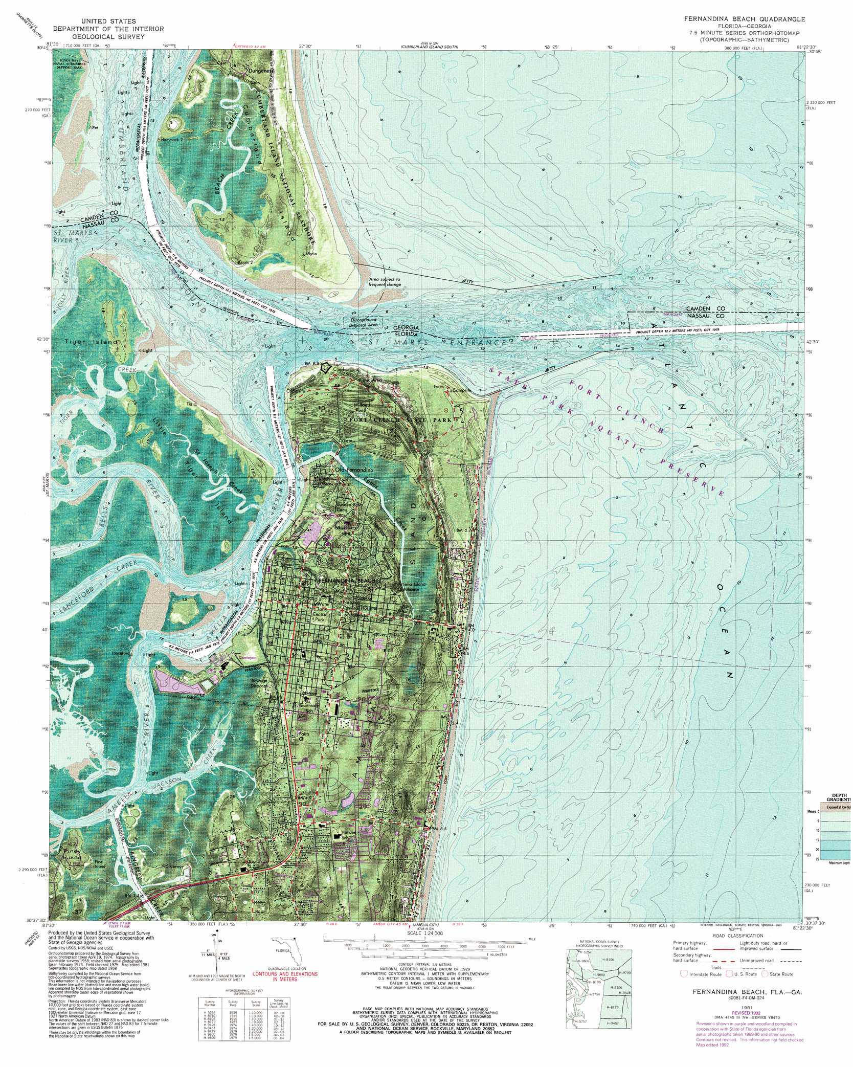
USGS Topo Quad 30081f4 - 1:24,000 scale
| Topo Map Name: | Fernandina Beach |
| USGS Topo Quad ID: | 30081f4 |
| Print Size: | ca. 21 1/4" wide x 27" high |
| Southeast Coordinates: | 30.625° N latitude / 81.375° W longitude |
| Map Center Coordinates: | 30.6875° N latitude / 81.4375° W longitude |
| U.S. States: | FL, GA |
| Filename: | P30081F4.jpg |
| Download Map JPG Image: | Fernandina Beach topo map 1:24,000 scale |
| Map Type: | Orthophoto |
| Topo Series: | 7.5´ |
| Map Scale: | 1:24,000 |
| Source of Map Images: | United States Geological Survey (USGS) |
| Alternate Map Versions: |
Fernandina Beach FL 1958, updated 1959 Download PDF Buy paper map Fernandina Beach FL 1958, updated 1971 Download PDF Buy paper map Fernandina Beach FL 1981, updated 1981 Download PDF Buy paper map Fernandina Beach FL 1981, updated 1988 Download PDF Buy paper map Fernandina Beach FL 1981, updated 1992 Download PDF Buy paper map Fernandina Beach FL 1981, updated 1992 Download PDF Buy paper map Fernandina Beach FL 1994, updated 2002 Download PDF Buy paper map Fernandina Beach FL 2011 Download PDF Buy paper map Fernandina Beach FL 2012 Download PDF Buy paper map Fernandina Beach FL 2015 Download PDF Buy paper map |
1:24,000 Topo Quads surrounding Fernandina Beach
Woodbine |
Kingsland Ne |
Cumberland Island North |
||
Kingsland |
Harrietts Bluff |
Cumberland Island South |
||
Gross |
Saint Marys |
Fernandina Beach |
||
Italia |
Hedges |
Amelia City |
||
Trout River |
Eastport |
Mayport |
> Back to 30081e1 at 1:100,000 scale
> Back to 30080a1 at 1:250,000 scale
> Back to U.S. Topo Maps home
Fernandina Beach topo map: Gazetteer
Fernandina Beach: Airports
Baptist Medical Center of Nassau Heliport elevation 6m 19′Nassau General Hospital Heliport elevation 6m 19′
Fernandina Beach: Bays
Cumberland Sound elevation 0m 0′Fernandina Beach: Bridges
Thomas J Shave, Junior, Bridge elevation 1m 3′Fernandina Beach: Channels
City Front Reach elevation 0m 0′Old Town Reach elevation 0m 0′
Quarantine Reach elevation 0m 0′
Rayonier Reach elevation 0m 0′
Saint Marys Entrance elevation 0m 0′
Saint Marys Entrance elevation 0m 0′
Seaboard Reach elevation 0m 0′
Fernandina Beach: Islands
Big Marsh Island elevation 0m 0′Little Tiger Island elevation 1m 3′
Piney Island elevation 1m 3′
Fernandina Beach: Parks
Central Park elevation 6m 19′Fernandina Plaza Historic State Park elevation 6m 19′
Fort Clinch State Park elevation 3m 9′
Fernandina Beach: Populated Places
Amelia Island Mobile Home Park elevation 2m 6′Dungeness elevation 5m 16′
Fernandina Beach elevation 3m 9′
Old Amelia Mobile Home Park elevation 3m 9′
Old Fernandina elevation 2m 6′
Ruby's Mobile Home Park elevation 3m 9′
Fernandina Beach: Streams
Amelia River elevation 0m 0′Beach Creek elevation 0m 0′
Bells River elevation 0m 0′
Egans Creek elevation 0m 0′
Jackson Creek elevation 0m 0′
Jolly River elevation 0m 0′
Kingsley Creek elevation 0m 0′
Lanceford Creek elevation 0m 0′
Saint Joseph Creek elevation 0m 0′
Saint Marys River elevation 0m 0′
Saint Marys River elevation 0m 0′
Soap Creek elevation 0m 0′
Tiger Creek elevation 0m 0′
Fernandina Beach: Summits
McClure Hill elevation 10m 32′Fernandina Beach digital topo map on disk
Buy this Fernandina Beach topo map showing relief, roads, GPS coordinates and other geographical features, as a high-resolution digital map file on DVD: