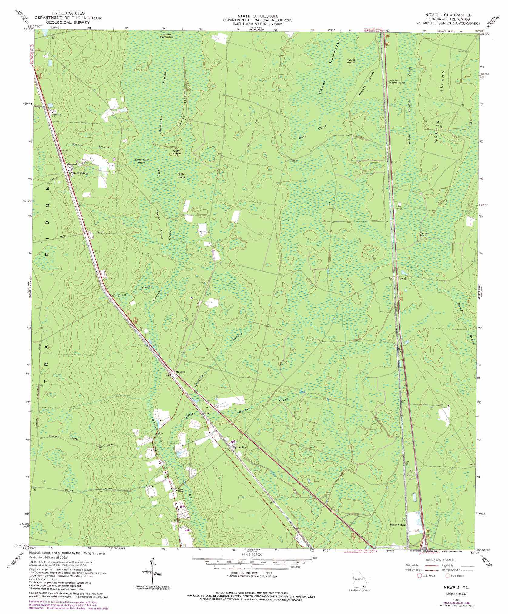
Newell Topo Map Georgia
To zoom in, hover over the map of Newell
USGS Topo Quad 30082h1 - 1:24,000 scale
| Topo Map Name: | Newell |
| USGS Topo Quad ID: | 30082h1 |
| Print Size: | ca. 21 1/4" wide x 27" high |
| Southeast Coordinates: | 30.875° N latitude / 82° W longitude |
| Map Center Coordinates: | 30.9375° N latitude / 82.0625° W longitude |
| U.S. State: | GA |
| Filename: | o30082h1.jpg |
| Download Map JPG Image: | Newell topo map 1:24,000 scale |
| Map Type: | Topographic |
| Topo Series: | 7.5´ |
| Map Scale: | 1:24,000 |
| Source of Map Images: | United States Geological Survey (USGS) |
| Alternate Map Versions: |
Newell GA 1966, updated 1967 Download PDF Buy paper map Newell GA 1966, updated 1988 Download PDF Buy paper map Newell GA 2011 Download PDF Buy paper map Newell GA 2014 Download PDF Buy paper map |
1:24,000 Topo Quads surrounding Newell
Waycross East |
Hoboken West |
Hoboken East |
Nahunta |
Waynesville |
Waycross Se |
Fort Mudge |
Winokur |
Boons Lake |
Tarboro |
Dinner Pond |
Double Lakes |
Newell |
Burnt Fort |
Jerusalem |
Billys Island |
Chase Prairie |
Folkston |
Boulogne |
Kings Ferry |
Blackjack Island |
Chesser Island |
Toledo |
Hilliard |
Hilliard Ne |
> Back to 30082e1 at 1:100,000 scale
> Back to 30082a1 at 1:250,000 scale
> Back to U.S. Topo Maps home
Newell topo map: Gazetteer
Newell: Flats
Trouble Valley elevation 21m 68′Newell: Islands
Cedar Hammocks elevation 21m 68′Clay Island elevation 23m 75′
Macks Island elevation 23m 75′
Rabbit Island elevation 21m 68′
Rabbit Island elevation 22m 72′
Sandy Island elevation 23m 75′
Sweet Gum Island elevation 22m 72′
Turkey Island elevation 23m 75′
Warren Island elevation 25m 82′
Wilson Hammock elevation 22m 72′
Newell: Populated Places
Cypress Siding elevation 39m 127′Mattox elevation 20m 65′
Newell elevation 23m 75′
Petersons (historical) elevation 22m 72′
Uptonville elevation 26m 85′
Newell: Streams
Little Spanish Creek elevation 14m 45′Melton Branch elevation 22m 72′
Newell: Swamps
Caney Branch elevation 20m 65′Dark Thick elevation 21m 68′
Little Okefenokee Swamp elevation 22m 72′
Mays Bluff Branch (historical) elevation 19m 62′
Winding Branch elevation 19m 62′
Newell digital topo map on disk
Buy this Newell topo map showing relief, roads, GPS coordinates and other geographical features, as a high-resolution digital map file on DVD: