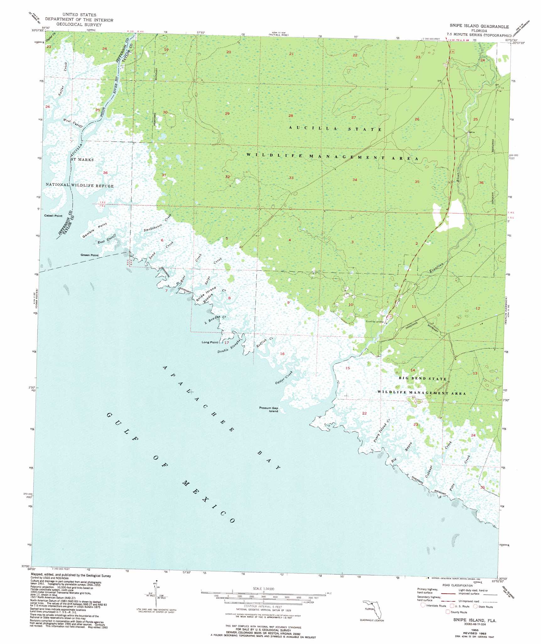
Snipe Island Topo Map Florida
To zoom in, hover over the map of Snipe Island
USGS Topo Quad 30083a8 - 1:24,000 scale
| Topo Map Name: | Snipe Island |
| USGS Topo Quad ID: | 30083a8 |
| Print Size: | ca. 21 1/4" wide x 27" high |
| Southeast Coordinates: | 30° N latitude / 83.875° W longitude |
| Map Center Coordinates: | 30.0625° N latitude / 83.9375° W longitude |
| U.S. State: | FL |
| Filename: | O30083A8.jpg |
| Download Map JPG Image: | Snipe Island topo map 1:24,000 scale |
| Map Type: | Topographic |
| Topo Series: | 7.5´ |
| Map Scale: | 1:24,000 |
| Source of Map Images: | United States Geological Survey (USGS) |
| Alternate Map Versions: |
Snipe Island FL 1955, updated 1956 Download PDF Buy paper map Snipe Island FL 1955, updated 1972 Download PDF Buy paper map Snipe Island FL 1955, updated 1981 Download PDF Buy paper map Snipe Island FL 1955, updated 1990 Download PDF Buy paper map Snipe Island FL 1955, updated 1993 Download PDF Buy paper map Snipe Island FL 2012 Download PDF Buy paper map Snipe Island FL 2015 Download PDF Buy paper map |
1:24,000 Topo Quads surrounding Snipe Island
Woodville |
Cody |
Wacissa |
Lamont Se |
Shady Grove |
Saint Marks |
Saint Marks Ne |
Nutall Rise |
Johnson Hammock |
Secotan |
Sprague Island |
Cobb Rocks |
Snipe Island |
Manlin Hammock |
Hampton Springs |
Rock Islands |
Okefenokee Slough |
|||
> Back to 30083a1 at 1:100,000 scale
> Back to 30082a1 at 1:250,000 scale
> Back to U.S. Topo Maps home
Snipe Island topo map: Gazetteer
Snipe Island: Bays
Oyster Creek elevation 0m 0′Snipe Island: Capes
Cabell Point elevation 0m 0′Gamble Point elevation 0m 0′
Green Point elevation 0m 0′
Snipe Island: Channels
Bowden Creek elevation 0m 0′East Cutoff elevation 0m 0′
West Cutoff elevation 0m 0′
Snipe Island: Guts
Big Bayou elevation 0m 0′Double Sloughs elevation 0m 0′
Long Point elevation 0m 0′
Redfish Creek elevation 0m 0′
Snipe Island: Islands
Possum Gap Island elevation 0m 0′Snipe Island elevation 0m 0′
Snipe Island: Parks
Econfina River State Park elevation 0m 0′Snipe Island: Populated Places
Atawalia (historical) elevation 2m 6′Mandalay elevation 1m 3′
San Francisco de Oconi (historical) elevation 1m 3′
Snipe Island: Streams
Aucilla River elevation 0m 0′Cabbage Creek elevation 0m 0′
Econfina River elevation 0m 0′
L Bowden Creek elevation 0m 0′
Pearly Island Creek elevation 0m 0′
Pitts Creek elevation 0m 0′
Rose Creek elevation 0m 0′
Sand Creek elevation 0m 0′
Smokehouse Creek elevation 0m 0′
Snipe Creek elevation 0m 0′
Sulfur Creek elevation 0m 0′
Snipe Island digital topo map on disk
Buy this Snipe Island topo map showing relief, roads, GPS coordinates and other geographical features, as a high-resolution digital map file on DVD: