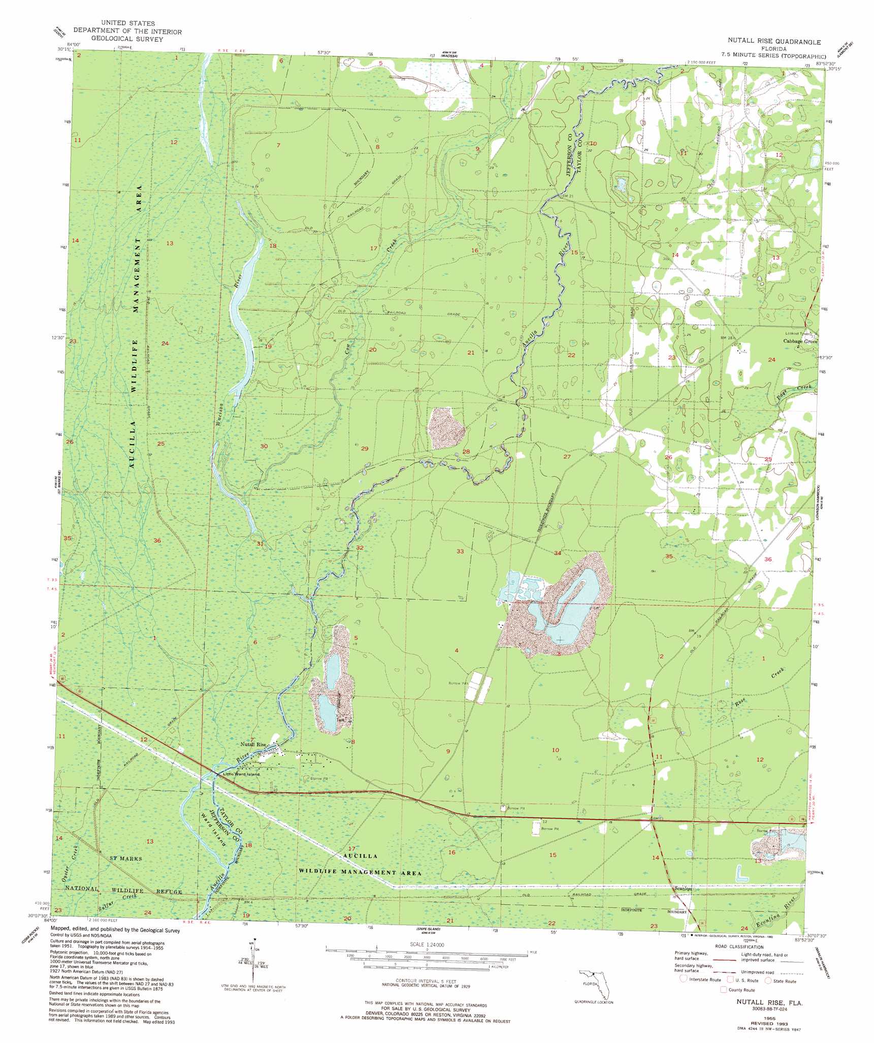
Nutall Rise Topo Map Florida
To zoom in, hover over the map of Nutall Rise
USGS Topo Quad 30083b8 - 1:24,000 scale
| Topo Map Name: | Nutall Rise |
| USGS Topo Quad ID: | 30083b8 |
| Print Size: | ca. 21 1/4" wide x 27" high |
| Southeast Coordinates: | 30.125° N latitude / 83.875° W longitude |
| Map Center Coordinates: | 30.1875° N latitude / 83.9375° W longitude |
| U.S. State: | FL |
| Filename: | O30083B8.jpg |
| Download Map JPG Image: | Nutall Rise topo map 1:24,000 scale |
| Map Type: | Topographic |
| Topo Series: | 7.5´ |
| Map Scale: | 1:24,000 |
| Source of Map Images: | United States Geological Survey (USGS) |
| Alternate Map Versions: |
Nutall Rise FL 1955, updated 1956 Download PDF Buy paper map Nutall Rise FL 1955, updated 1972 Download PDF Buy paper map Nutall Rise FL 1955, updated 1993 Download PDF Buy paper map Nutall Rise FL 2012 Download PDF Buy paper map Nutall Rise FL 2015 Download PDF Buy paper map |
1:24,000 Topo Quads surrounding Nutall Rise
Lafayette |
Lloyd |
Waukeenah |
Lamont |
Greenville |
Woodville |
Cody |
Wacissa |
Lamont Se |
Shady Grove |
Saint Marks |
Saint Marks Ne |
Nutall Rise |
Johnson Hammock |
Secotan |
Sprague Island |
Cobb Rocks |
Snipe Island |
Manlin Hammock |
Hampton Springs |
Rock Islands |
Okefenokee Slough |
> Back to 30083a1 at 1:100,000 scale
> Back to 30082a1 at 1:250,000 scale
> Back to U.S. Topo Maps home
Nutall Rise topo map: Gazetteer
Nutall Rise: Canals
Slave Canal elevation 1m 3′Nutall Rise: Flats
Goose Pasture elevation 4m 13′Nutall Rise: Islands
Bushy Hammock elevation 5m 16′Hells Half Acre elevation 5m 16′
Little Ward Island elevation 0m 0′
Powell Hammock elevation 4m 13′
Ward Island elevation 1m 3′
Nutall Rise: Parks
Aucilla Wildlife Management Area elevation 3m 9′Nutall Rise: Populated Places
Buckhorn elevation 3m 9′Ilcombe (historical) elevation 4m 13′
Nutall Rise elevation 0m 0′
San Juan de Guacara (historical) elevation 4m 13′
Scanlon elevation 4m 13′
Nutall Rise: Streams
Cow Creek elevation 2m 6′Page Creek elevation 7m 22′
Wacissa River elevation 0m 0′
Nutall Rise digital topo map on disk
Buy this Nutall Rise topo map showing relief, roads, GPS coordinates and other geographical features, as a high-resolution digital map file on DVD: