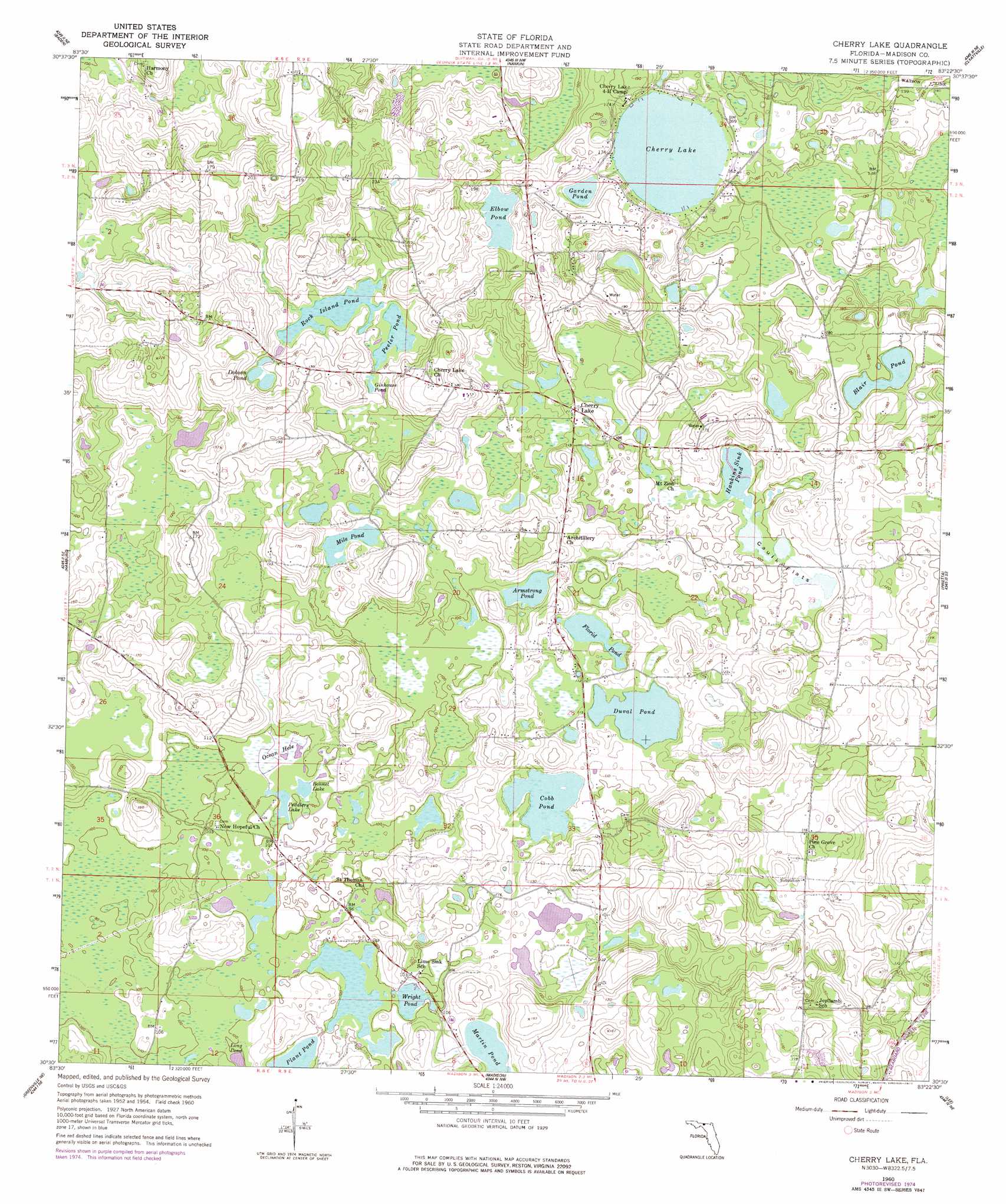
Cherry Lake Topo Map Florida
To zoom in, hover over the map of Cherry Lake
USGS Topo Quad 30083e4 - 1:24,000 scale
| Topo Map Name: | Cherry Lake |
| USGS Topo Quad ID: | 30083e4 |
| Print Size: | ca. 21 1/4" wide x 27" high |
| Southeast Coordinates: | 30.5° N latitude / 83.375° W longitude |
| Map Center Coordinates: | 30.5625° N latitude / 83.4375° W longitude |
| U.S. State: | FL |
| Filename: | O30083E4.jpg |
| Download Map JPG Image: | Cherry Lake topo map 1:24,000 scale |
| Map Type: | Topographic |
| Topo Series: | 7.5´ |
| Map Scale: | 1:24,000 |
| Source of Map Images: | United States Geological Survey (USGS) |
| Alternate Map Versions: |
Cherry Lake FL 1960, updated 1961 Download PDF Buy paper map Cherry Lake FL 1960, updated 1977 Download PDF Buy paper map Cherry Lake FL 1960, updated 1977 Download PDF Buy paper map Cherry Lake FL 2012 Download PDF Buy paper map Cherry Lake FL 2015 Download PDF Buy paper map |
1:24,000 Topo Quads surrounding Cherry Lake
Dixie |
Quitman |
Ousley |
Valdosta |
Indianola |
Grooverville |
Baden |
Nankin |
Clyattville |
Lake Park |
Ashville |
Hamburg |
Cherry Lake |
Pinetta |
Octahatchee |
Greenville |
Greenville Ne |
Madison |
Lee |
Ellaville |
Shady Grove |
Greenville Se |
Madison Sw |
Madison Se |
Falmouth |
> Back to 30083e1 at 1:100,000 scale
> Back to 30082a1 at 1:250,000 scale
> Back to U.S. Topo Maps home
Cherry Lake topo map: Gazetteer
Cherry Lake: Airports
Rocky Ford Stolport elevation 33m 108′Cherry Lake: Flats
Caulk Flats elevation 30m 98′Cherry Lake: Lakes
Armstrong Pond elevation 32m 104′Blair Pond elevation 45m 147′
Bonnet Lake elevation 30m 98′
Cherry Lake elevation 47m 154′
Cobb Pond elevation 32m 104′
Dobson Pond elevation 41m 134′
Duval Pond elevation 32m 104′
Elbow Pond elevation 47m 154′
Florid Pond elevation 31m 101′
Garden Pond elevation 50m 164′
Ginhouse Pond elevation 38m 124′
Hankins Sink Pond elevation 29m 95′
Long Pond elevation 29m 95′
Martin Pond elevation 35m 114′
Mile Pond elevation 34m 111′
Peddlers Lake elevation 30m 98′
Peeler Pond elevation 30m 98′
Peeler Pond elevation 37m 121′
Plant Pond elevation 29m 95′
Rock Island Pond elevation 37m 121′
Wright Pond elevation 38m 124′
Cherry Lake: Populated Places
Cherry Lake elevation 35m 114′Cherry Lake: Swamps
Ocean Hole elevation 31m 101′Cherry Lake digital topo map on disk
Buy this Cherry Lake topo map showing relief, roads, GPS coordinates and other geographical features, as a high-resolution digital map file on DVD: