Queens Bay Topo Map Florida
To zoom in, hover over the map of Queens Bay
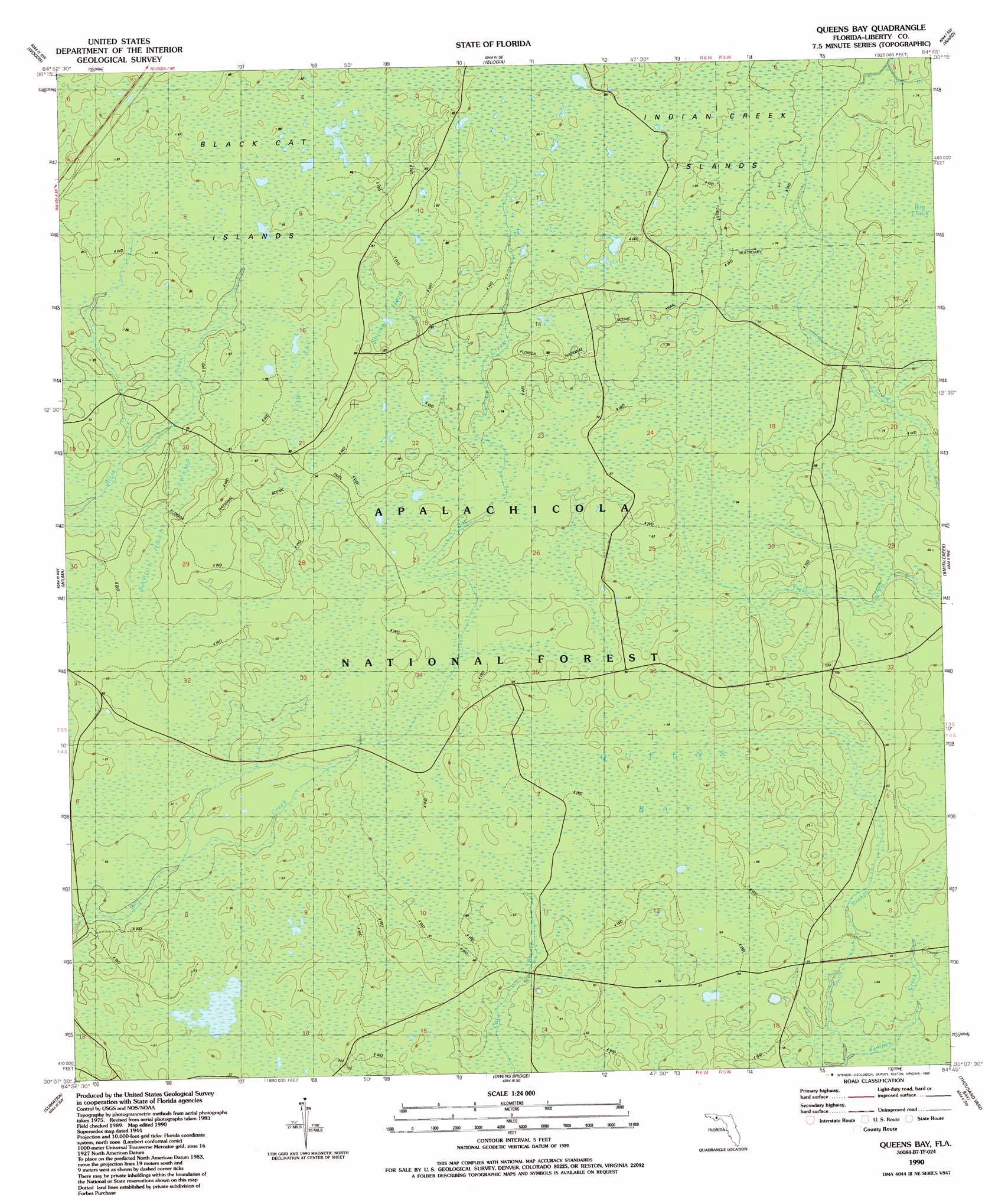
USGS Topo Quad 30084b7 - 1:24,000 scale
| Topo Map Name: | Queens Bay |
| USGS Topo Quad ID: | 30084b7 |
| Print Size: | ca. 21 1/4" wide x 27" high |
| Southeast Coordinates: | 30.125° N latitude / 84.75° W longitude |
| Map Center Coordinates: | 30.1875° N latitude / 84.8125° W longitude |
| U.S. State: | FL |
| Filename: | O30084B7.jpg |
| Download Map JPG Image: | Queens Bay topo map 1:24,000 scale |
| Map Type: | Topographic |
| Topo Series: | 7.5´ |
| Map Scale: | 1:24,000 |
| Source of Map Images: | United States Geological Survey (USGS) |
| Alternate Map Versions: |
Queens Bay FL 1944, updated 1968 Download PDF Buy paper map Queens Bay FL 1946, updated 1960 Download PDF Buy paper map Queens Bay FL 1990, updated 1990 Download PDF Buy paper map Queens Bay FL 2012 Download PDF Buy paper map Queens Bay FL 2015 Download PDF Buy paper map |
| FStopo: | US Forest Service topo Queens Bay is available: Download FStopo PDF Download FStopo TIF |
1:24,000 Topo Quads surrounding Queens Bay
Blountstown |
Bristol |
Hosford |
Bloxham |
Lake Talquin |
Estiffanulga |
Woods |
Telogia |
Ward |
Lake Talquin Se |
Orange |
Wilma |
Queens Bay |
Smith Creek |
Bradwell Bay |
Kennedy Creek |
Sumatra |
Owens Bridge |
Thousand Yard Bay |
Sanborn |
Forbes Island |
Fort Gadsden |
Tates Hell Swamp |
Pickett Bay |
Mcintyre |
> Back to 30084a1 at 1:100,000 scale
> Back to 30084a1 at 1:250,000 scale
> Back to U.S. Topo Maps home
Queens Bay topo map: Gazetteer
Queens Bay: Bays
Low Bay elevation 24m 78′Queens Bay elevation 19m 62′
Queens Bay: Islands
Black Cat Islands elevation 25m 82′Indian Creek Islands elevation 24m 78′
Queens Bay: Streams
Swift Branch elevation 15m 49′Queens Bay: Swamps
Big Thick elevation 21m 68′Saplin Head Swamp elevation 21m 68′
Spring Head elevation 24m 78′
Queens Bay digital topo map on disk
Buy this Queens Bay topo map showing relief, roads, GPS coordinates and other geographical features, as a high-resolution digital map file on DVD:
Gulf Coast (LA, MS, AL, FL) & Southwestern Georgia
Buy digital topo maps: Gulf Coast (LA, MS, AL, FL) & Southwestern Georgia
 & Southwestern Georgia map DVD")