Woods Topo Map Florida
To zoom in, hover over the map of Woods
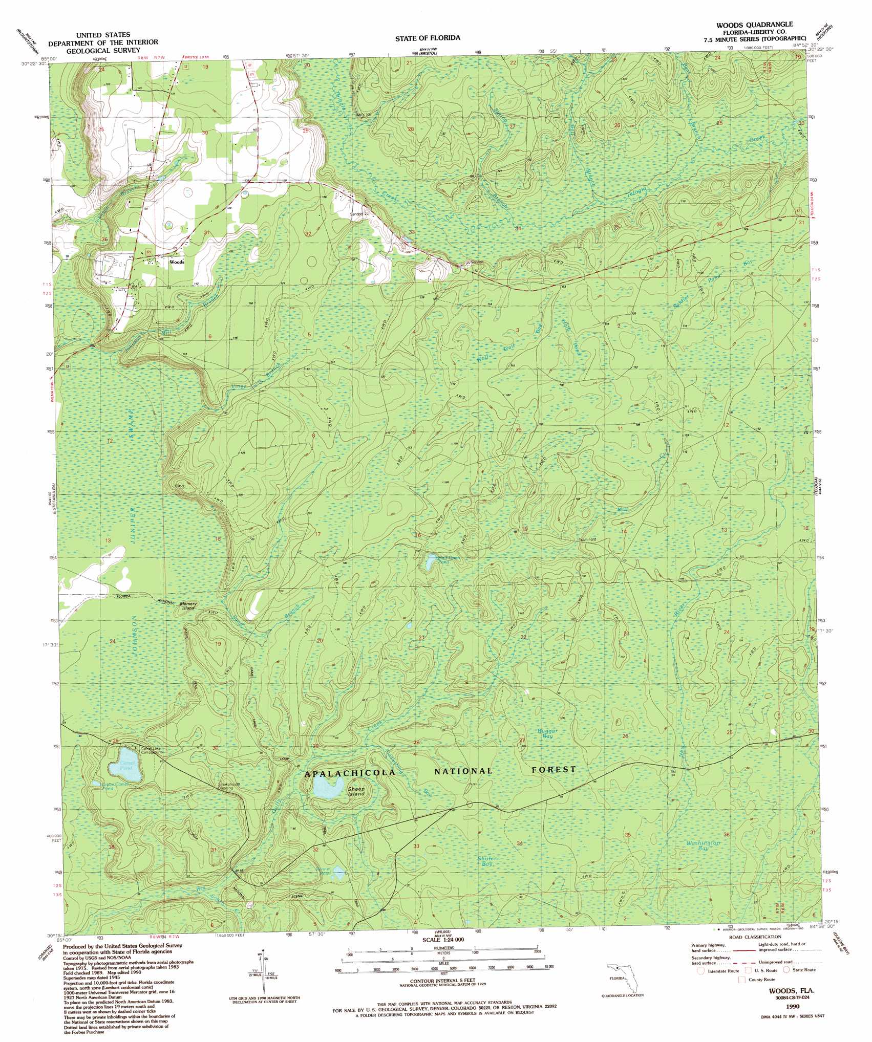
USGS Topo Quad 30084c8 - 1:24,000 scale
| Topo Map Name: | Woods |
| USGS Topo Quad ID: | 30084c8 |
| Print Size: | ca. 21 1/4" wide x 27" high |
| Southeast Coordinates: | 30.25° N latitude / 84.875° W longitude |
| Map Center Coordinates: | 30.3125° N latitude / 84.9375° W longitude |
| U.S. State: | FL |
| Filename: | O30084C8.jpg |
| Download Map JPG Image: | Woods topo map 1:24,000 scale |
| Map Type: | Topographic |
| Topo Series: | 7.5´ |
| Map Scale: | 1:24,000 |
| Source of Map Images: | United States Geological Survey (USGS) |
| Alternate Map Versions: |
Woods FL 1945, updated 1960 Download PDF Buy paper map Woods FL 1945, updated 1960 Download PDF Buy paper map Woods FL 1990, updated 1990 Download PDF Buy paper map Woods FL 2012 Download PDF Buy paper map Woods FL 2015 Download PDF Buy paper map |
| FStopo: | US Forest Service topo Woods is available: Download FStopo PDF Download FStopo TIF |
1:24,000 Topo Quads surrounding Woods
Altha West |
Altha East |
Rock Bluff |
Sycamore |
Gretna |
Clarksville |
Blountstown |
Bristol |
Hosford |
Bloxham |
Frink |
Estiffanulga |
Woods |
Telogia |
Ward |
Dead Lake |
Orange |
Wilma |
Queens Bay |
Smith Creek |
Wewahitchka |
Kennedy Creek |
Sumatra |
Owens Bridge |
Thousand Yard Bay |
> Back to 30084a1 at 1:100,000 scale
> Back to 30084a1 at 1:250,000 scale
> Back to U.S. Topo Maps home
Woods topo map: Gazetteer
Woods: Islands
Memery Island elevation 21m 68′Sheep Island elevation 28m 91′
Woods: Lakes
Bonnet Pond elevation 27m 88′Camel Pond elevation 20m 65′
Half Open Pond elevation 25m 82′
Little Camel Pond elevation 19m 62′
Woods: Populated Places
Fawn Ford elevation 25m 82′Woods elevation 37m 121′
Woods: Streams
Bear Branch elevation 22m 72′Goff Branch elevation 23m 75′
Johnson Mill Branch elevation 17m 55′
Mill Creek elevation 24m 78′
Sand Branch elevation 16m 52′
South Creek elevation 12m 39′
Spring Branch elevation 23m 75′
Viney Branch elevation 18m 59′
Woods: Swamps
Buggar Bay elevation 28m 91′Fiddlestring Bay elevation 27m 88′
Holy Pond elevation 33m 108′
Johnson Juniper Swamp elevation 16m 52′
Shuler Bay elevation 28m 91′
Soldier Pond Bay elevation 37m 121′
Washington Bay elevation 26m 85′
Wolf Trail Bay elevation 32m 104′
Woods: Trails
Trail of the Lakes elevation 17m 55′Woods digital topo map on disk
Buy this Woods topo map showing relief, roads, GPS coordinates and other geographical features, as a high-resolution digital map file on DVD:
Gulf Coast (LA, MS, AL, FL) & Southwestern Georgia
Buy digital topo maps: Gulf Coast (LA, MS, AL, FL) & Southwestern Georgia
 & Southwestern Georgia map DVD")