Tallahassee Topo Map Florida
To zoom in, hover over the map of Tallahassee
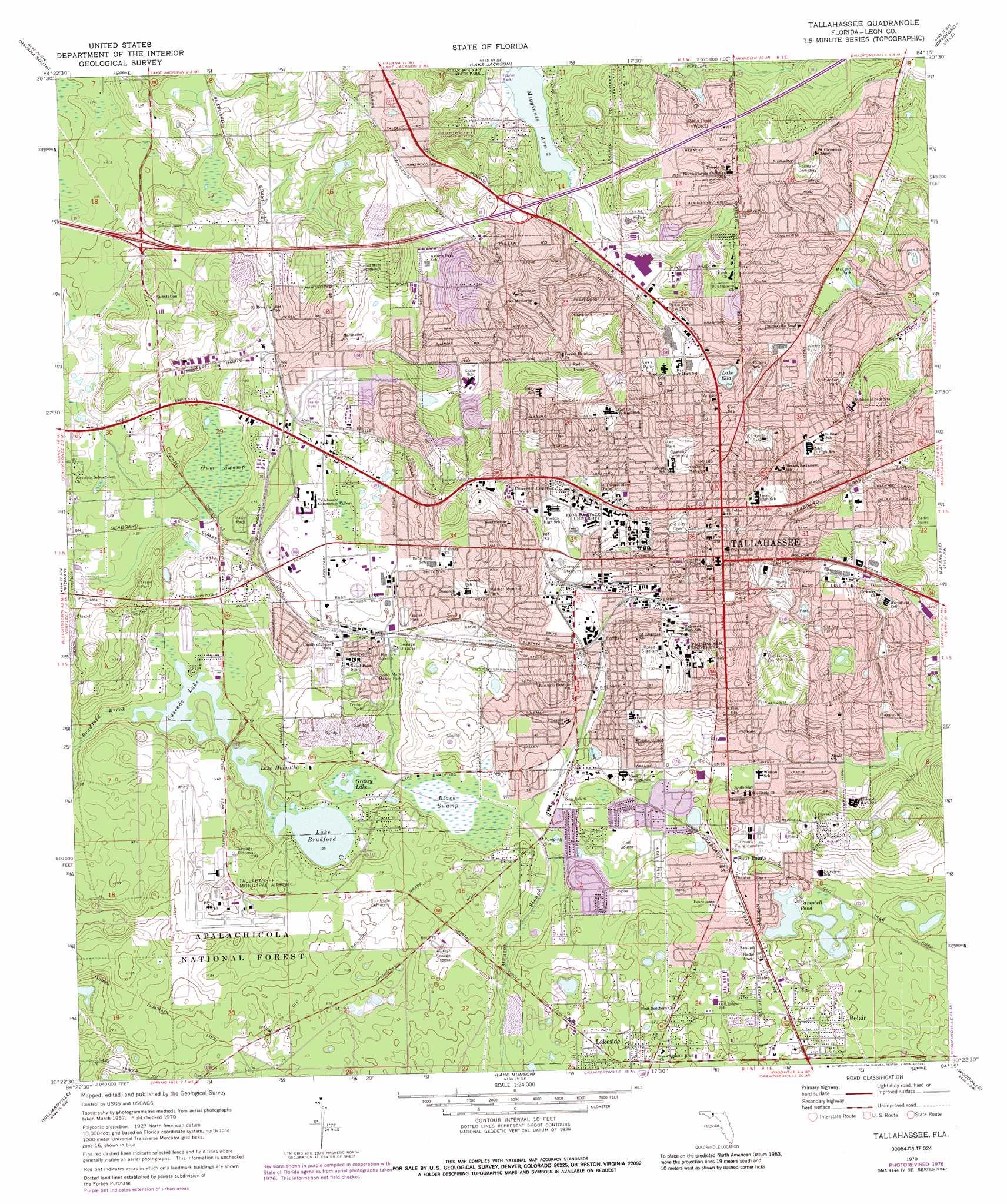
USGS Topo Quad 30084d3 - 1:24,000 scale
| Topo Map Name: | Tallahassee |
| USGS Topo Quad ID: | 30084d3 |
| Print Size: | ca. 21 1/4" wide x 27" high |
| Southeast Coordinates: | 30.375° N latitude / 84.25° W longitude |
| Map Center Coordinates: | 30.4375° N latitude / 84.3125° W longitude |
| U.S. State: | FL |
| Filename: | O30084D3.jpg |
| Download Map JPG Image: | Tallahassee topo map 1:24,000 scale |
| Map Type: | Topographic |
| Topo Series: | 7.5´ |
| Map Scale: | 1:24,000 |
| Source of Map Images: | United States Geological Survey (USGS) |
| Alternate Map Versions: |
Tallahassee FL 1970, updated 1972 Download PDF Buy paper map Tallahassee FL 1970, updated 1977 Download PDF Buy paper map Tallahassee FL 1970, updated 1987 Download PDF Buy paper map Tallahassee FL 1970, updated 1987 Download PDF Buy paper map Tallahassee FL 1999, updated 2000 Download PDF Buy paper map Tallahassee FL 2012 Download PDF Buy paper map Tallahassee FL 2015 Download PDF Buy paper map |
| FStopo: | US Forest Service topo Tallahassee is available: Download FStopo PDF Download FStopo TIF |
1:24,000 Topo Quads surrounding Tallahassee
Dogtown |
Havana North |
Calvary |
Beachton |
Miccosukee Ne |
Quincy |
Havana South |
Lake Jackson |
Bradfordville |
Miccosukee |
Lake Talquin |
Midway |
Tallahassee |
Lafayette |
Lloyd |
Lake Talquin Se |
Hilliardville |
Lake Munson |
Woodville |
Cody |
Bradwell Bay |
Crawfordville West |
Crawfordville East |
Saint Marks |
Saint Marks Ne |
> Back to 30084a1 at 1:100,000 scale
> Back to 30084a1 at 1:250,000 scale
> Back to U.S. Topo Maps home
Tallahassee topo map: Gazetteer
Tallahassee: Airports
Tallahassee Memorial Hospital Heliport elevation 59m 193′Tallahassee Regional Airport elevation 18m 59′
Tallahassee: Bays
Megginnis Arm elevation 29m 95′Tallahassee: Bridges
M S Thomas Bridge elevation 33m 108′Tallahassee: Lakes
Campbell Pond elevation 10m 32′Cascade Lake elevation 10m 32′
Grassy Lake elevation 10m 32′
Gum Pond elevation 24m 78′
Lake Bradford elevation 10m 32′
Lake Ella elevation 48m 157′
Lake Hiawatha elevation 10m 32′
Tallahassee: Parks
Bragg Stadium elevation 32m 104′Burnett Park elevation 38m 124′
Capital Field elevation 22m 72′
Centennial Field elevation 29m 95′
Chittenden Park elevation 61m 200′
Doak S. Campbell Stadium elevation 19m 62′
Harriman Circle Park elevation 27m 88′
Lafayette Park elevation 56m 183′
Lake Jackson Mounds Archaeological State Park elevation 32m 104′
Lee Park elevation 44m 144′
Levy Park elevation 60m 196′
Los Robles Park elevation 63m 206′
McCord Park elevation 26m 85′
Myers Park elevation 41m 134′
Old Fort Park elevation 64m 209′
Optimist Park elevation 37m 121′
Palmer Monroe Park elevation 30m 98′
South Mabry Manor Park elevation 28m 91′
Tallahassee-Saint Marks Historic Railroad Trail State Park elevation 19m 62′
Winthrop Park elevation 37m 121′
Tallahassee: Populated Places
Belair elevation 14m 45′Four Points elevation 20m 65′
Henrietta elevation 24m 78′
Lakeside elevation 12m 39′
Macon elevation 65m 213′
Tallahassee elevation 62m 203′
Zion Hill elevation 42m 137′
Tallahassee: Streams
Bradford Brook elevation 10m 32′Tallahassee: Swamps
Black Swamp elevation 11m 36′Gum Swamp elevation 14m 45′
Tallahassee digital topo map on disk
Buy this Tallahassee topo map showing relief, roads, GPS coordinates and other geographical features, as a high-resolution digital map file on DVD:
Gulf Coast (LA, MS, AL, FL) & Southwestern Georgia
Buy digital topo maps: Gulf Coast (LA, MS, AL, FL) & Southwestern Georgia
 & Southwestern Georgia map DVD")